


![]()
You are here
History of Tanymas Valley.

Walking tour on Pamir in Tajikistan.
"Cracks and ice ridges completely blocked the road in all directions"
N.I. Kosinenko.
Sights of nature of Pamirs.
Even the very name of the valley - Tanymas - speaks of the mystery of these places. “He will not know” in the sense of “he will not be friendly” - this is how the famous Central Asian scholar N.L. Korzhenevsky. For the first time, the Tanymas Valley is mentioned in the reports of the Pamir expedition of 1883.
From the stories of Tajiks, travelers learned that this valley (up to 25 versts in length) stretches to the west, where it closes with high mountains. But they did not have a chance to visit Tanymas. Only four years later, the valley was visited by researchers - members of the expedition G.E. Grumm Grzhimailo.
They conducted a route survey of part of the valley, noting on the map the languages of several glaciers discovered by the expedition. They were given the general name "Glaciers of Count Sheremetev." However, judging by the latest data, the expedition visited only the lower part of the valley, and the map compiled by it suffered significant inaccuracies.
In the summer of 1908, detachment N.I. visited the valley Kosinenko. In search of a pass to the Western Pamir, the researcher sought to break through to its upper reaches, but the first attempt to climb the glacier blocking the valley across its entire width was unsuccessful.
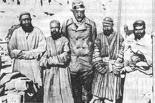
“Cracks and ice ridges completely blocked the road in all directions,” he wrote in his report. Sixteen years later, already after the Great October Socialist Revolution, N.L. went to the Tanymas Valley. Korzhenevsky, from the beginning of the century systematically exploring the Pamirs.
In 1925, the road to the Pamirs was still unsafe: one could expect a raid of Basmachi gangs. Korzhenevsky left with one assistant and a small detachment of Red Army soldiers. Already from afar, from the heights of the Kok-Dzhar valley, the traveler saw the end of a large glacier.
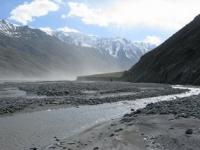
From the west, another glacier adjoined it, not inferior to the first in size. It seemed to Korzhenevsky that, descending from the southwest and west, the glaciers merge with their snout glaciers. A small caravan, having hardly overcome the crossing through a full-flowing stream, moved up the Tanymas valley.
Having walked 20 kilometers up the valley, Korzhenevsky went to the foot of a high ice cliff. It was a tongue of a glacier that seemed to flow down the valley from east to west. Korzhenevsky concluded: “The Tanymas glacier is formed by the merger of two branches, of which the smaller one flows from the southwest, and the larger one, which seems to be a direct continuation of the glacier, flows from the west-southwest.
The first of these branches ... is relatively narrow and a steep-sided gorge, located approximately two kilometers from the end of Tanymas "1. The smaller of the glaciers, Korzhenevsky called Muz-Kulak (Icy Ear). The researcher suggested that the glacier has a small extent.
Soon Korzhenevsky fell dangerously ill and was forced to stop work. A short stay in the valley, bad weather, a deceptive impression created when observing glaciers from a distance of about 30 kilometers, led to a number of errors in the orographic scheme of this area.
Only in 1928, the Tanymass Valley and the adjacent gorges were thoroughly investigated. This problem was solved by the expedition of the USSR Academy of Sciences. It turned out that a tongue of a glacier crawls out of a large gorge, from the south, which then turns to the east and blocks the Tanymas valley.
The glacier, flowing almost exactly from west to east, also exists in the valley, but it is located much to the west and has no direct connection with the first glacier. Moreover, this is by no means an independent glacier, but an excess of ice flowing from the huge Fedchenko Glacier through the lowering of the ridge into the Tanymas Valley.
Research in 1928 confirmed one of the guesses of N.L. Korzhenevsky; in 1925 he wrote that at the head of the Tanymas glacier, you can find a connection with the Fedchenko Glacier and reach the legendary passes to the Western Pamir.
It is this assumption of N.L. Korzhenevsky determined the choice of the path of the Pamir expedition of the USSR Academy of Sciences in 1928. Her troops headed along the valley of Tanymas deep into the unexplored part of the Pamirs.
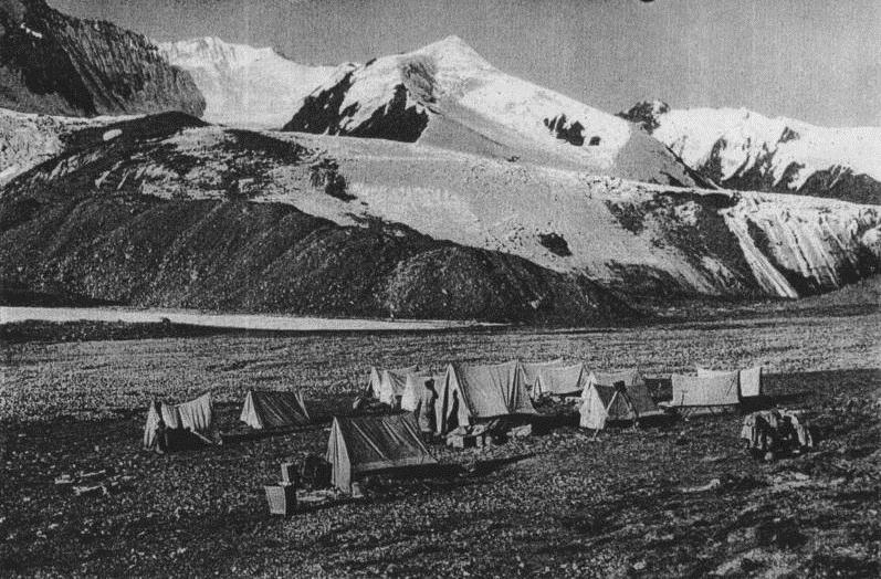
The expedition provided great material for the knowledge of an unexplored mountain area near Fedchenko Glacier. The survey of this mountain site was carried out by the topographer of the 1928 expedition I.G. Dorofeev and members of the same expedition, German surveyors.
During the shooting, the Germans climbed the peaks of Middle Tanymas (5500 meters) and the White Horn (5800 meters) and some other peaks. German climbers also tried to climb the main peak of the peak region of the Revolution, but they failed.
Subsequently, the Tanymas Valley was visited more than once, but the mountain group to the south of it and the glaciers remained relatively little studied. The main glacier of the group was studied only by teams of geologists K.N. Paffengolz (1934), M.I. Shabalkin (1937) and P.A. Shumsky (1944). Shumsky collected interesting materials on the physical geography of the area.
In 1928, the Germans, members of the expedition of the USSR Academy of Sciences, renamed the Muz-Kulak glacier to Notgemeinschaft (this name is indicated on a number of old maps). In 1948, at the request of the Geographical Society of the USSR, the Presidium of the Supreme Council of the Tajik SSR assigned the Muz-Kulak glacier the name of the original investigator G.E. Grumm Grzhimailo.
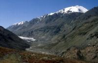
The main mountain junction and the main glacier of the region lie south of the Tanymas Valley, directly adjacent to the Southern Group of the Fedchenko Glacier Ridge.
Ranges and glaciers are stretched from south to north. From the west, the border of the node is the High Wall ridge, from the south - the Nameless ridge1 (on the southern slopes of it - the Khabarviv-Khats river basin), from the east - the Cold Wall ridge.
In the southwestern corner of the district, at the junction of the ridges of the southern group of the Fedchenko and Bezymyanny glaciers, the main peak of the region rises in the peak of the Revolution (6987 meters) - a huge massif, completely covered with ice and snow.
The entire space between the Nameless Range and the spur almost parallel to it is filled with firn and ice. This is where the Grumm-Grzhimailo glacier originates. A huge reservoir of solid precipitation up to 3-4 kilometers wide arose due to the proximity of the Fedchenko Glacier.
Further east, the amount of precipitation decreases sharply, and only 20 kilometers from here, already in Kok-Dzhar, the arid zone typical of the Eastern Pamirs begins, glaciers are almost absent. Of the total area of 248.5 square kilometers occupied by glaciers, 160 square kilometers are accounted for by the Grumm-Grzhimailo glacier basin.
The next largest is the Tanymas II Glacier basin, which has an area of only 22 square kilometers. The Grumm-Grzhimailo Glacier has ten left tributaries and five right tributaries. Among them are such large as the glaciers Upper Muz-Kulak, or Schwarzengorn (length 11 kilometers) and Small Muz-Kulak (8 kilometers).
Many tributaries of the Grumm-Grzhimailo glacier, in turn, are formed by the merger of several branches, and this entire complex system ends with the language of the main glacier, whose total length is 37 kilometers.
From 1928 to 1933, the Grumm-Grzhimailo glacier advanced, its end advanced 375 meters and its height increased by 50 meters. Not far from the exit to the Tanymas Valley, the tongue of the glacier bends from north to west, and then makes a sharp turn to the east and, going into the valley, spreads across its entire width.
The ice is almost clear, there is no powerful surface moraine usual for glaciers of Central Asia. The end of the Tanymas glacier has the same appearance. Only in places on the ice surface is a thin layer of dust brought by the winds.
Tanymas Valley
Far far away
In the heart of the Pamirs
Where are the trails not to be seen
And Kutas will not work,
There is a wonderful song
Flies over the world -
This youth sings our victory..
And to storm the impregnable
Giants of the Pamirs
Climbers go out
On a high altitude hike.
Everyone sang the last verse together:
Far and hard
Way to the heights.
Need a lot of skill
A storm of victory to begin,
To complete the task -
Edge to glorify darling,
New stone tour
Taken the peak to crown.
Authority:
"Days in the Pamirs." Zatulovsky D., Krasavin L. Ed. AUCCTU, Profizdat, 1956.