


![]()
You are here
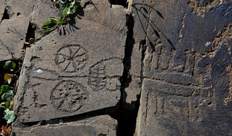
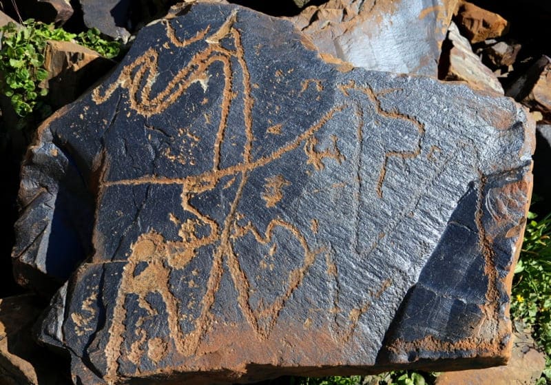
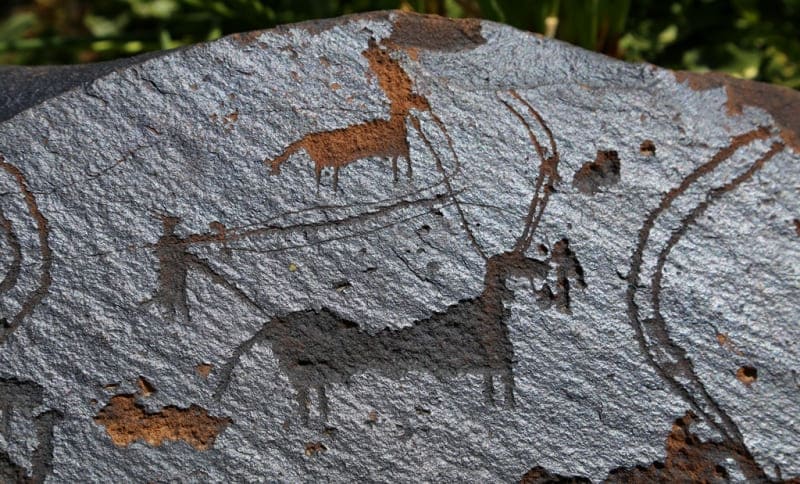
History of petroglyphs of Saimaluu-Tash.


Excursion tours to petroglyphs of Kyrgyzstan.
“No matter how approximate these calculations are, they are still very close to reality and indicate that in terms of the number of images with the complex in Saimaly-Tash, similar clusters known to us not only in Asia, but all over the world are hardly comparable.
The absolute predominance of plots and compositions coming from the thinking of people associated with the mountain landscapes of the Tien Shan gives reason to believe that Saimaly-Tash is, first of all, the brightest cultural monument of the mountain and pastoral tribes who created here a grandiose "mountain temple" that has not died for thousands of years.»
A.N. Bernshtam.
Rock paintings of Kyrgyzstan.
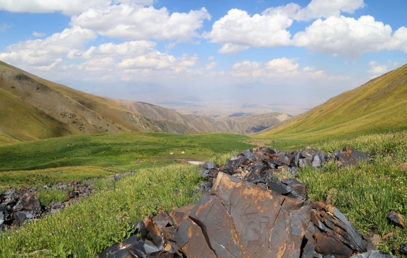
In summer of 1902, while conducting surveys along postal road from Naryn to Andijan, military topographer N.G. Khludov learned from local residents about Saimaly-Tash valley near Kugart pass in the Ferghana Range.
The name seemed strange to him (Saimaly-Tash in Kyrgyz means a patterned stone), and from further inquiries it turned out that in the tract there are stones with images of people and animals. N.G. got there with great difficulty.
Khludov to Saimaluu-Tash (over 3,000 m. a. s. l.), made sketches of several images and took a plan of the area.
Nikolai Gavrilovich Khludov was born on November 25, 1850 in the city of Bryansk, Oryol province, Russian Empire.
Khludov is an artist, portrait painter, icon painter, landscape painter and chronicler of the Trans-Ili region. Born in the family of a draftsman and fireworker of the Bryansk Arsenal. His father Gavriil Vasilievich is the author of a graphic panorama of Bryansk, made with the help of a camera obscura from the left bank of the Desna River in 1857.
He studied at the Odessa drawing school in the period from 1872 to 1874, then continued his education in private art workshops in St. Petersburg, in the workshop of Gogolevsky. Since 1877 he lived in the city of Verny, now Almaty.
Khludov worked as a draftsman, and later surveyor of the Semirechensk regional government, participated as a topographer and artist in the expeditions of the geologist I.V. Ignatiev and the botanist A.N. studying the Vernensky earthquake in 1887, was a member of the Turkestan circle of archeology lovers, the founder of the Semirechensky department of the Russian Geographical Society.
Khludov in 1904 - 1907 painted the first iconostasis of the Verny Ascension Cathedral, built according to the project of the architect A.P. Zenkov. In 1910 - 1917 he was a teacher of drawing and drawing at the Vernensky Higher Primary School, a teacher's seminary and a women's gymnasium.
In 1918-1919 he taught drawing and drafting at the Verny Agricultural College. Along the way, he travels to the Kazakh steppe and draws a lot. Since 1921, he has been the head of the studio, where he has been working with emerging artists.
In Soviet times, he played an important role in the professional training of the first Kazakh and Kyrgyz artists. Abylkhan Kasteev (1904 - 1973), Alexei Bortnikov (1909 - 1980) and Semyon Chuikov (1902 - 1980) from Pishpek were the students of N. G. Khludov at different times.
The organizer of the 1st art exhibition of the Soviet Semirechye in 1925, a solo exhibition in the period from 1921 to 1930, took part in the Moscow exhibitions "The Art of the Peoples of the USSR" in 1927, "The Art of the Kazakh ASSR" in 1934, the Museum of the Peoples of the East.
The great artist died on June 23, 1935 in the city of Alma-Ata, Kazakh ASSR. He sent all these materials, together with a brief message, to the Turkestan Circle of Archeology Lovers (TKLA). Thus, an exceptionally interesting monument of the ancient culture of the peoples of Central Asia was opened - a high-mountain "art gallery".
Having heard the message of N.G. Khludov, TKLA decided to ask General I.T. Poslavsky, a member of the circle, who had a relationship with the construction of the road, to conduct a detailed study on Saimaluu-Tash. However, a detailed study was not obtained.
Due to the difficult road, I.T. Poslavsky got there later than he expected, and only had time to examine the drawings and make a few copies. But even a cursory examination was enough to resolutely confirm N.G.'s assumption. Khludov about the deep antiquity of rock paintings.
In his message, I.T. Poslavsky noted that many months are needed to study Saimaluu-Tash. The study of the Saimaluu-Tash petroglyphs resumed only after more than forty years. In 1946, a historical and archaeological expedition led by B.M. In winter, he dedicated a number of works to this monument.
He notes that in 1946 only the eastern section of the tract was surveyed. The first complete survey of Saimaluu-Tash was carried out by a group of employees of the Pamir-Fergana expedition headed by A.N. Bernshtam in 1950
A.N. Bernshtam made the greatest contribution to the study of this complex of petroglyphs, rare in richness and diversity.
He created the first classification and periodization scheme for plots and styles of Saimaly-Tash drawings. Although A.N. Bernshtam considered this scheme preliminary, but over the past 25 years it has not been substantially corrected by anyone and almost not supplemented.
It is known that A.N. Bernshtam was going to return to a detailed study of Saimaluu-Tash, but did not have time to do so. The features of the topography of the tract prompted A.N. Bernshtam on the idea that some of the images were damaged in ancient times by a powerful tectonic shock, and the other part, later, was knocked out on the fragments of the rock crumbling after the earthquake.
The time of the disaster is determined by A.N. Bernshtam at the beginning of the 1st millennium BC. If this was really the case, then there is an additional opportunity to date those groups of drawings that are difficult to determine chronologically, at least they can be attributed to the time before or after the rockfall.
Then, in 1963, they were studied by N.L. Podolsky with the idea, innovative for that time, of statistical analysis of the proportions of drawings; he also proposed a four-point scale for assessing the density of "desert tan". Classification N.L. Podolsky basically confirmed the chronological scheme of A.N. Bernshtam. In 1966 - 1968 Yu.N. Golendukhin, and in 1968 - 1973 - G.A. Pomaskin.
In the second half of the 20th century, Ya.A. Sher, A.I. Martynov (Russia from the city of Kemerovo), A.N. Maryashev, A.E. Rogozhinsky (Kazakhstan, Almaty), G.A. Pomaskina, K.I. Tashbaeva (Kyrgyzstan, Bishkek), A.P. Frankfort (France, CNRS). The last scientific examination of the monument was carried out in 2002 by a group led by K.I. Tashbayeva.
In 2007, the object was examined by the staff of the Department of Archeology and Ethnography of the Dzhusup Balasagyn National University of Kyiv. The current state of the monument. The inaccessibility of the monument and specific climatic conditions make it protected from excessive anthropogenic impact, ensuring the preservation of the monument and landscape.
Thanks to journal articles and a review by Zh. Frumkin, this monument became widely known to Soviet and foreign readers.
Geographical coordinates of rock paintings of Saimaluu-Tash: N41°10'47 E73°48'53
Authority:
Ya.A. Cher. “On the interpretation of the plots of some petroglyphs of Saimaly-Tash. Culture of the East. Antiquity and the Early Middle Ages. L: Aurora. 1978. Pp. 163 - 171.
Alexander Petrov.
Photos by:
Alexander Petrov.