


![]()
You are here
History of exploration of Anyrakay mountains.
Mountain ranges in Kazakhstan.
“Do I look into the blue, where the eagle is circling,
Where a camel caravan floats into the horizon,
On the sea or the steppe, on the mountain peaks -
I see only your whole world eclipsing the camp."
Baba Tahir. "Both heaven and earth..." End of X – XI centuries.
Trip to Kazakhstan mountains.
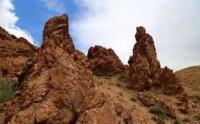
Anyrakay mountains are located at an altitude of 1000 to 1242.6 meters above sea level, are located in the Kordai district in the east of the Zhambyl region. The Anyrakai Mountains, together with the foothill plains surrounding them, were first recorded in writing under this name and examined in detail in the period from July 16 to August 5, 1843 by members of the natural-science expedition of the St. Petersburg Academy of Sciences, headed by the famous Russian scientist A.I. Schrenk.
He paid great attention to the desert flora and fauna of the places he visited and described them in detail in his handwritten field diary, written in cursive Gothic in German. Following A. I. Shrenk, a journey to the Chu-Ili region in 1853 - 1854. made by the military topographer T. F. Nifantiev, but his detailed handwritten report on the survey of the territory of the South-Western Balkhash region has not yet been found in the archives.
In the late 50s - mid-60s. In the XIXth century, field studies, topographic surveys and astronomical determinations of points on the earth's surface were carried out in Western Semirechye M. I. Istokov, V. A. Poltoratsky, A. F. Golubev, V. A. Struve, Ch. Ch. Valikhanov and some other researchers.
Thanks to their research, the Anyrakai Mountains and the valleys of the Kopala and Sarybulak rivers cutting through them were clearly marked for the first time in the cartography of this region, and the mountains, in addition, were named in writing on the forty-verst line drawn up in 1868 by the staff captain of the Corps of Military Topographers M. G. Lyusilin " Map of the Turkestan Governor General.
In the second half of the XIXth - early XXth centuries, the Anyrakai section of the Chu-Ili mountain system was more or less thoroughly examined by botanists A.N. Krasnov (1886) and M.I. Ptashitsky, statisticians V.E. Nedzvetsky (1909) ) and P. P. Rumyantsev (1911), geologist B. F. Meffert (1910), soil scientists A. I. Bessonov and G. M. Tumin (1914), geographer R. I. Abolin ( 1916) and some other scientists, but there is practically no specific information about the natural boundaries and natural sights of the Anyrakai historical area in their published scientific articles and reports on field research.
In direct connection with the history of the Kazakh-Oirat wars, the natural landscapes of the Anyrakay mountains and adjacent foothill and plain zones of the Western Semirechye (Zhambyl district of Almaty region, Moyinkum and Shu districts of Zhambyl region) began to be explored only after the collapse of the Soviet Union and the formation of a sovereign Republic of Kazakhstan.
Geographic coordinates of Anyrakai Mountains: N43°59'22.11" E75°12'25.21"
Authority:
"Anyrakay Triangle Historical-Geographical Area and Chronicle of the Great Battle". I.V. Erofeeva, B.Zh. Aubekerov, A.E. Rogozhinsky, B.N. Kaldybekov, B.T. Zhanaev, L.L. Kuznetsova, R.D. Sala, S.A. Nigmatova, J.M.P. Deom. Almaty, 2008. "Dyke Press".
Photos by
Alexander Petrov.