


![]()
You are here
History of Erk Kala ancient settlement.
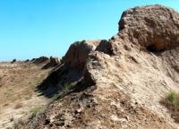
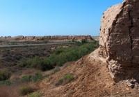
Photo tours in historical and cultural park "Ancient Merv".
"I saw - do not hide, did not see - do not talk"
Turkmen proverb.
Photos of archaeological monuments of Turkemenistan.
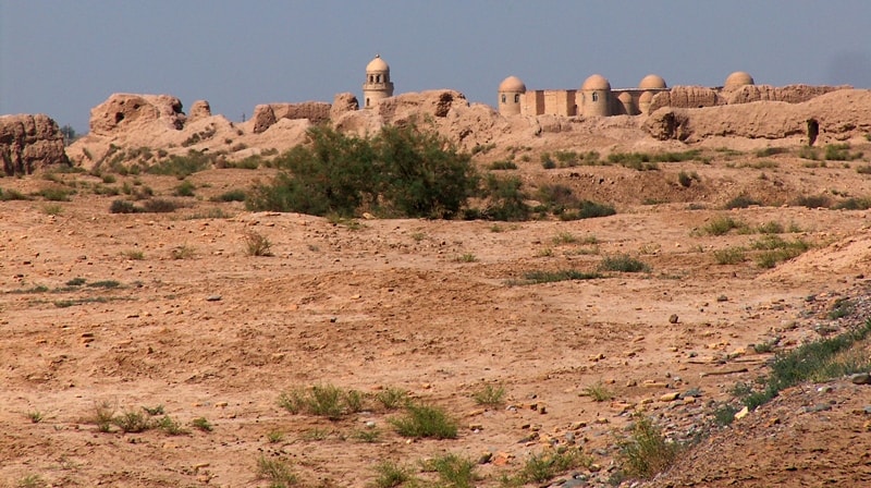
Erk Kala settlement is located on a natural hill 261.9 m. a. s. l.l, located on the territory of the historical and cultural park "Ancient Merv", 6.3 kilometers north-east of the city of Bayramali, 4.1 kilometers to the south-west from the Internationale settlement, 2.5 kilometers to the east and a little north of the Sultan Sanjar mausoleum in the Bayramaly etrap of the Mary velayat.
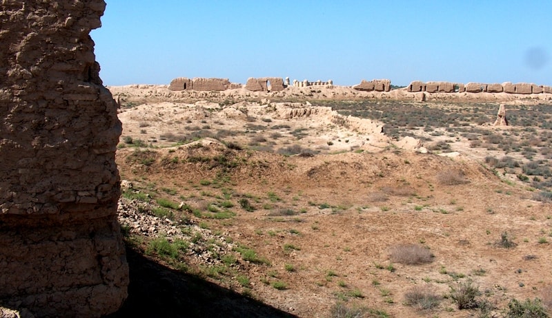
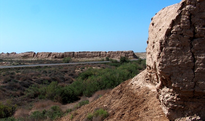
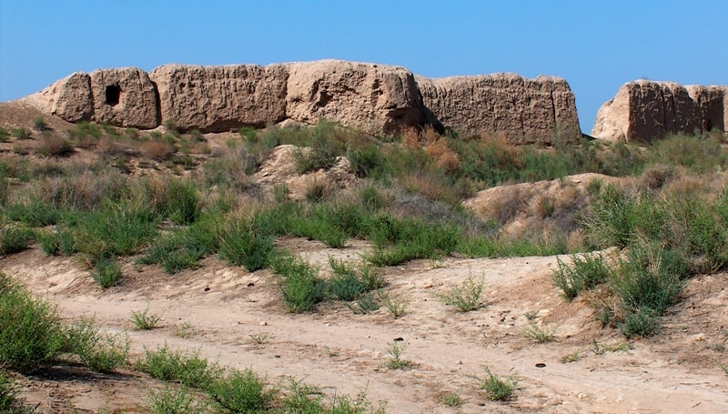
The ruins of the Old Merv include five settlements of differnt times and are located in the middle reaches of the Murgab River in the territory of Turkmenistan. The oldest of them is Erk kala, oval in plan (400x500 meters - 20 hectares), inscribed in the northern face of the fortress walls of the Gyaur kala settlement.
The only ramp to Erk Kala was on the south side. The swells of its fortress walls rise by 23-27 meters, in the center of the settlement, with a shift to the south-west, there is a citadel (50x50 meters) with a height of more than 25 meters, hills of former buildings adjoin it from the south and east, to the north of the citadel, before the fortress walls, a reduced area is allocated, which was used for the location of the military garrison and the installation of stone-throwing guns.
The first excavations at Erk Kala were carried out in 1890 by V.A. Zhukovsky through the Archaeological Commission. In 1904, exploration work was carried out by an American expedition led by R. Pampelli. In 2004, Turkmenistan widely celebrated the 100th anniversary of the discovery by the Americans of the "culture of Anau" and the excavations in Merv.
In 1937, excavation work at Erk kala was carried out by BB. Piotrovsky, A.A. Marushchenko and in 1947 S.A. Vyazigin, and in 1950 stationary archaeological surveys began under the YTAKE line under the leadership of Academician M.E. Masson, which lasted until 1992.
As a result of the section of the fortress wall, brought to the mainland, factual material was obtained for solving the problems of ancient urbanization and methods of urban planning. At the base of the walls there were early adobe fortifications, built on with elongated mud, with ceramics, with a pronounced beak-shaped rim and oblique walls at the transition to the bottom.
These findings in the 70s of the XX century made it possible to speak about the time of the emergence of the fortified settlement not earlier than the middle of the 1st millennium BC. However, a stratigraphic pit buried south of the central mound of Erk Kala, 17 meters deep, revealed at the mainland level two early cultural layers with material similar to dishes from ancient walls, and the ancient buried bog soils with fragments of ceramics indicated an earlier date of habitation of this territory - from the second quarter of the Ist millennium B.C., which was then confirmed by excavations on the central hillock in 1986-1992.
Here, at excavation site 7, reliable facts were obtained of the presence of an early cultural layer at the boundary between the Yaz I and Yaz II cultures, corresponding to the buried soils in the stratigraphic pit. On this basis, in recent publications, the author of these lines dates the age of Erk Kala within 2700 years.
The section of the central hill-citadel of Erk Kala along the northern slope showed that at its base there is a platform of rectangular raw material, decorated along the northern face with angular protrusions, forming a deepened niche, along the edge of which, at a height of 15 meters, there was a fire temple in the open air, which functioned simultaneously with the early buildings of the settlement.
A blazing bonfire was visible outside the city walls, which were much lower than 10 meters of the citadel itself. Thus, the materials obtained during the forty-year study of Erk Kala make it possible to recreate the historical picture of the development of an urban settlement on the territory of Ancient Merv.
The fortified point appears here at the turn of the change of cultures Yaz I and Yaz II. A powerful platform of the citadel is being erected from raw materials, with a functioning temple of fire and buildings that have left a cultural layer of more than 2 meters on the eastern slope of the platform, with early ceramics.
A fragment of molded painted utensils of the Yaz I type was found with an admixture of chamotte and grit in the dough, covered with a thick engobe, on which a geometric painting was applied. Finds in the 35th tier of a two-bladed, socketed, bronze arrowhead and a stone biconical core, characteristic of ancient Margian settlements, are associated with the same layer.
Above this ancient cultural layer, a building with adobe walls of the Achaemenid period has been uncovered. In one of the rooms on the northern slope, large jugs with vertical walls were found, dug into the floor, ending in a rim in the form of a flat roll, giving a profile of the beak in section, pulled down, and covered with a light engobe until the walls were braced when going to the bottom, dug into floor.
Several three feather bronze arrowheads with a protruding sleeve, similar to arrows from the palace of Darius I in Persepolis, have been encountered. This stage in the history of Erk Kala is associated with the period of the entry of Margiana into the Achaemenid state in the VIth-IVth centuries. B.C.
The city walls of Erk Kala are additionally strengthened and new palace and temple buildings are being built on the platform of the citadel. Such Erk kala was found by the Greek troops and in honor of their commander they named her Alexandria of Margiana.
Erk kala of that period had a great similarity in layout and history of addition to the modern town of Bactra. In the Hellenistic era (IV-III centuries BC) Erk kala loses its status of an independent urban organism and, as a ready-made fortified citadel, is included in the northern face of the fortress walls as an integral part of a new rectangular city under construction under Antiochus. I Soter.
Since that time, the history of Erk Kala will be inextricably linked with the development of the ancient city on the territory of Gyaur-Kala. Erk Kala, enclosed by walls, intensively settled down mainly to the south and southeast of the former citadel (central hill), while the northern half remained free.
Even now it is a lowland, where in ancient times an arsenal and stone-throwing tools were located. The further history of Erk Kala is connected with the construction and functioning from the II century. B.C. the palace temple complex to the east of the city gates, as well as residential quarters for the ruling class, adjacent to the central hill on the east side, where cultural layers of ancient times have been preserved.
The accumulation of cultural layers of the Sassanian time is noted to the southeast of the central hill, where the total thickness of the cultural layer reaches 17 meters, of which 5 meters fall on the Sassanian period. There are no later layers on Erk kale.
The period of the entry of Margiana into the Sassanian state (III-V centuries) left a significant mark in the history of Erk Kala. On the central hill, on top of the ancient building, on a powerful platform, an administrative building is being erected, which was then used by the Arabs as the residence of Caliph Mamun in Merv.
To the west of the central hill, at the foot of the fortress wall, was an arsenal. At the southern gate, on the site of the palace temple complex, a fort is being built, decorated along the northern face with a wall with false loopholes, in one of which a terracotta figurine of a woman warrior with a sword was found.
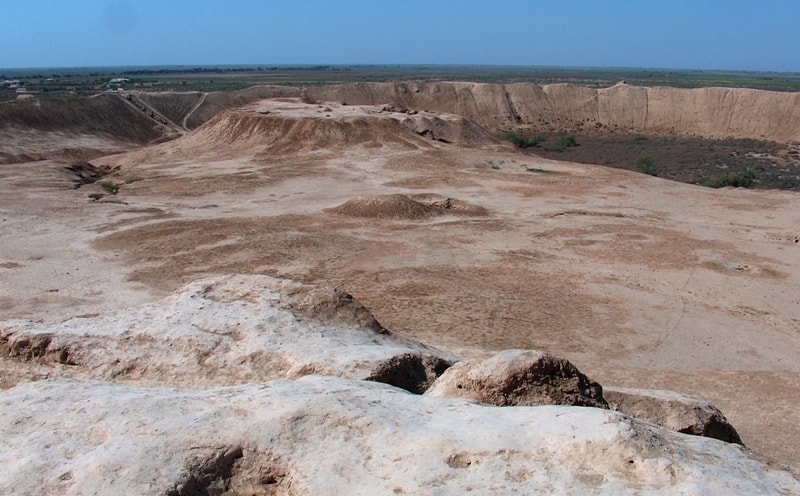
The drifts of the fort are currently located at a height of 34 meters from the level of the base of the fortress wall, from its upper platform a wide panorama of the surroundings up to 30 kilometers in the area opens up. The Sassanids paid great attention to strengthening the borders of their state in the northeast, and therefore in Merv, and in particular in Erk Kala, large-scale construction was carried out - proteikhisms, walls with double, parallel intra-wall corridors, etc. were being built.
In order to obtain new data on the historical topography of the settlement and to reveal the nature of cultural layers, in 1990-1991, excavations were carried out 100 meters east of the central hill on one of the hills bordering the lowland of the northern part of the settlement.
Fragments of mostly utensils, well known from the Merv ceramic scale for the IIIrd-VIIth centuries, were raised from the surface. A rather loose upper layer was formed as a result of centuries of destruction of former buildings and leaks.
Remains of structures at the excavation site were found only at a depth of 1.5-2 meters.
A part of a residential building, consisting of 4 rooms, was opened, two floor levels were installed, connected with two construction periods. The stratigraphy of the strata proved to be complex due to several major overhauls and repairs. The basis of the dwelling house is a room with grooved walls; wall hearths with an accumulation of whole vessels were cleared on the floor: hum, khumchi, a kitchen boiler.
To the north of the vessels were two millstones and a wedge-shaped brick. In the second construction period, on the filling of the room, a new floor level is arranged, which overlaps the leveled southern wall. The dimensions of the new premises are significantly increased due to the expansion to the south, while maintaining the old northern wall.
In this case, the room located to the south of the room is blocked. At this stage, the walls are being built from raw material 38x42 cm in size, 10-12 cm thick. indoors, the first floor level lowers to the south by 15-20 cm. It showed an accumulation of whole vessels and their fragments, which are of exceptional interest, since they were sandwiched between the floors and can be dated more accurately.
This complex made it possible to clarify the chronological framework of the existence of different forms of tableware, which ended up here together, while taken separately, they could be dated to different times. In particular, this applies to jugs with legs, which are usually attributed to a later time.
A feature of the room is the absence of a southern wall, which is clearly visible from the eastern wall, which has preserved a smooth southern edge, with traces of the former plaster. The room is an iwan open to the courtyard, which served as a ceremonial room 4.5 meters long and 2.2 meters wide, and is typical of the Parthian-Sassanid palace architecture.
Such ayvans were also used in residential architecture, acting as ceremonial premises, with an exit to the courtyard. For Merv, this is a unique discovery that allows us to talk about new principles of planning and building techniques in the residential architecture of Erk Kala, given that it served as a citadel-fortress even under the Parthians and Sassanids.
Room 3 is located to the east of room 2, the entrance was from the courtyard. The walls are made of raw material 40x42x10x11 cm, with the use of halves for bandaging. The western wall adjoined the eastern wall of the second room, creating additional support for the vaulted ceiling of the iwan.
Above the southern doorway, there are traces of the transition to the vault. One meter from the western wall in tiers IV-V, a pit was found lowered from above, in the loose filling of which 32 fragments of ostracons were found. The inscriptions are in black ink on the walls of gray earthenware; some have inscriptions on both sides.
By the outline of letters and cursive writing, which are characteristic of the Middle Persian handwriting (Pahlavi on the Aramaic basis), the ostracs can be attributed to the VIth-VIIth centuries. Initial acquaintance with the find allowed A.B. Nikitin put them in the same category as the ostracas from the Buddhist monument in Merv and date them to the VIth-VIIth centuries.
To the north of room 3 was room 4, in which the floor level with hearths was marked. Nearby were wedge-shaped bricks and an inverted hum used as a tandoor. The floor covers the filling of rooms 1 and 2, and it is connected with the destroyed upper cultural layer.
The copper coins found at the excavation were identified by A.B. Nikitin as Sassanian, national and local coinage. Ceramics from the first floor of rooms 1 and 2 are represented by the following forms: hums, jugs, cauldrons, jugs of various types, pots, bowls, a large mug like a glass with one handle.
All dishes are made on a potter's wheel, a good quality shard, pink gray and yellowish colors with light, pink and gray engobe. On some vessels there are traces of vertical corrugation, ornaments in the form of wavy lines. Grit and sand are added to the dough of kitchen utensils, the surface is smoothed, engobe is well preserved. In the filling of room 3, fragments of glassware, bronze arrowheads, a bronze lining of a knife handle, a stone mold, and a ceramic censer were found.
The stratigraphy of the excavation made it possible to establish that the southeastern part of the settlement was intensively settled in the IIIrd-Vth centuries.
AD The revealed floor levels indicate several stages of construction and repairs at the same site, which indicates the dense development of the territory of the citadel, where it was not possible to live scattered within the powerful city walls.
This is what determined here such a powerful accumulation of cultural layers.
The dwelling house at Excavation 9 is being built on the ruins of a building from the previous era in the middle of the 3rd century. AD, when Merv was part of the Sassanian state. Since the IV century, a real military threat appeared from the northern nomadic tribes and Merv was constantly in sight of the Sassanian kings.
Shapur II entered into an agreement with the Chionites and Galans. The crisis phenomena greatly weakened Merv, especially under Hormizd (302-309). There is a certain decline in the economic life of the country. On Gyaur Kale, an entire sector is empty, where mainly the craft quarters of coppersmiths, millers, ceramists and glassblowers were located.
On Erk Kale, the building at excavation site 3 is falling into decay, as well as an object at the site of the future arsenal. On these hills, there are no materials on the surface later than the IIIrd - IVth centuries. The economic downturn was exacerbated by the fight against the Hephthalites in the first half of the Vth century.
Varakhran V (420-438) defeats the Hephthalites near Merv, and Ezdigird II constantly held army on the northern border, for which he founded a military headquarters in the Merv oasis. However, the military actions of Ezdegerd II against the Hephtalites and Chionites ended in defeat.
This struggle weakened the Sassanian state and severely affected Merv, which was the scene of military clashes. At the beginning of the 5th century, the oasis was still experiencing economic decline. It was at this time that not only the Christian community quietly existed on the empty territory of Gyauk Kala (IV - early Vth century), but also the Buddhist community in the southeastern part of the settlement, where the stupa and sangarama were built.
During this difficult period for Merv on Erk Kala, a dwelling house, studied at excavation 9, functioned. which now lived a new landed aristocracy, which constituted the support of state power. The last stage in the history of Erk Kala is associated with the Arabs, when during the period of the Caliph's stay, the town gates and crests of the fortress walls were fortified with small-sized baked bricks.
Since the Xth century, Erk Kala, according to written sources, is in ruins.
Geographic coordinates of Erk Kala ancient settlement: N37°40'10 E62°11'31
Literature:
1. Zhukovsky V.A. "Ruins of Old Merv". Antiquities of the Transcaspian Territory. ZVO, XI. SPb., I894. Pages: 327 - 333.
2. Schmidt H. Arceological Excavations in Anau and Merv. Explorations in Turkestan. Expedition of 1904. Vol. I. Washington, 1908.
3. UTAKE materials. Issue I. Ashgabat, 1949. Pages: 35 - 41.
4. Proceedings of UTAKE. T.XIX. Ashgabat, 1989. Pages: 21 - 62.
5. Proceedings of UTAKE. T. XIV. Ashgabat, 1969. Pages: 13 - 56.
6. Usmanova Z.I. "New material on ancient Merv". Iran. XXX. 1992. P. 55 - 63.
7. Masson V.M. "Ancient agricultural culture of Margiana". MIA. 73.M. - L., 1959.
8. Z.I. Usmanov. Tashkent. “On the history of Erk Kala”.
Photos by:
Alexander Petrov.