


![]()
You are here
History of Beket Ata mosques.

Mosques built by Beket Ata.
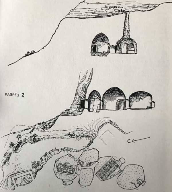
"... having climbed Ustyurt, an almost completely flat surface opened up, crowned by small hills along the mountain capes. Towards the end of the transition, the location became somewhat more undulating, but the elevations were very gentle and had no general direction. Ustyurt is entirely composed of rocky rocks of later formation, covered with a sandy-clay layer. The descents from the mountains are almost everywhere rocky and very steep. Under them, in many places, there were springs, sufficient only for a small number of horses, but the Kirghiz dam them to accumulate water. The richest of these springs was at the mosque of the supanin (hermit) Beket. The mosque was carved into a gypsum cliff and consisted of two rooms, the size of a Kirghiz tent; one of them had a low entrance, and the other was illuminated by an opening cut in the stone from above. Near the mosque there were several graves decorated with hewn quadrangular stones."
Report material for 1826 in a topographic journal.
Underground mosques Beket Ata mosque.
In the places of seasonal pastures Beket ata built four underground mosques:
- first is Akmechet mosque on the bank of the Emba River, in the Zhylyoi district of the Atyrau region,
- second mosque is underground mosque of Beket ata in Old Beineu in the chalk cliffs 15.7 kilometers southwest of the city of Beineu, in the Beineu district of the Mangistau region,
- third mosque is located in Bayaly area on Ustyurt plateau, near the Aral Sea, in the Bayaly area, "in the vicinity of the Aral Sea." (However, the presence of this mosque and, accordingly, its exact location have not been definitely proven (is it the Akshukur mosque (Akmechet dungeon), located on Ustyurt, somewhere 200 kilometers south-southeast of Beket-ata (Oglandy).
This monument, in particular, was mentioned by S.V. Viktorov and it is possible that the mosque is located in the area of the famous Baylar well (Bayali Eversman). At the same time, it is noted in the literature that these mosques were located in the places of seasonal pastures of the Beket aul.
As one of the mosques of Beket, the literature also indicates a cave in the Tobykty area on the Buzachi peninsula.
I. Myrzabekuly writes in one of his works:
... Based on the information left by the now deceased descendants of Beket-ata Zhortuyluli Maksym and Sauleuly Ermekbay, let us dwell in more detail on the existence of the Beket Ata mosque, located on the Ustyurt plateau, not far from Bayshagyr (Akshukur in the vicinity of Karabaur).
Beket Ata goes to worship at the burial place of Khoja Akhmed Yasawi in sacred Turkestan, or returns from there, on the way he stops at a small mosque built by him in Eastern Ustyurt, in this mosque he reads namaz and rests in it (Bayshagar - in the press they mistakenly write Bayaly).
The approximate distance between Ogylandy and Konyrat is about 500 kilometers. This mosque is located 300 kilometers from the city of Zhanaozen to the east, 350 kilometers from the regional center of Shomanay in Karakalpakstan, 340 kilometers from the city of Konyrat, 40 kilometers from the Shakpakty gas pipeline on the road to Beskala.
This mosque can easily accommodate 10 people and have the opportunity to read namaz, the mosque has survived to this day like an eye of history. About 2 centuries ago, the mosque, built from carved mountain blocks, is now heavily damaged.
In front of the mosque, one of the kind people put a metal plate with the inscription:
- "The house where Beket-ata read namaz."
The lonely building can be seen from afar, it is located on a small hill. To get to the mosque, you need to drive to the Karabaur ridge along country roads, cross the Baimen takir, drive through the saxauls of the Eltezhe area, go down the Kenderli hill.
Then, after driving a little, you can see this small mosque. In front of the mosque is the Bayzhan well. To the north of the mosque is the Akpan well. If you look to the west of the mosque, you will see the remains of a small medieval settlement.
At that time, travelers from Beskala to Mangistau passed through the Meshitsu area without fail, they always stopped at the Beket Ata mosque, read namaz and rested. On the map compiled in 1902 by the captain David Livkin, the Tabukty well is marked, but not the mosque.
If the Beket Ata mosque had existed at that time, then D. Livkin would have definitely indicated its location. The question of Tobykty remains open for us, but below we will provide information about this monument.
- fourth and last mosque is carved out of massif of a chalk rocky cape in Oglandy valley on the Western escarpment of the Ustyurt plateau, in the Karakiya district, Mangistau region.
Authority:
Otynshy Koshbayuly, Murat Kalmenov. "Underground mosques of Mangistau". Olketanymdyk bassylym. Almaty, Publishing house "Orkhon". 2009. 160 p.