


![]()
You are here
Glade "Togyz shoshak" in park Buiratau.
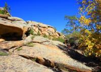
Photo tours in Kazakhstan.
“The steppe has been blooming for centuries and will not bloom soon.
For centuries, in the mountains, flowers caress the eyes.
Some come into the world, others are carried away by death,
And the steppe is still the same steppe, and the mountains are the same mountains.
Baba Tahir. "Both heaven and earth..." End of X – XI centuries.
Places of rest in Kazakhstan.
The Togyz Shoshak glade is located at an altitude of 392 meters above sea level, located in the southeastern part of the Sokolinye mountains valley, on the territory of the Yereymentau branch of the Buyratau Natural Park, 7.6 kilometers southwest of the village of Karagaily, 10.2 kilometers northwest of the village of Balykty, 8.2 kilometers west and slightly north of the archaeological complex of Kos Batyr, 3.4 kilometers north and slightly west of Mount Ortashoky, 450 meters above sea level, in the Yereymentau district in the north east of the Akmola region.
The picturesque glade "Togyz shoshak" is surrounded by granite remnants from 3 to 5 meters high in the southeast of the tract Sokolinye Gory. A bivouac has been set up in the clearing, where yurts are located, decorated with national attributes, a fire pit, Kazakh folk swings - Alty bakan.
Forged gazebos for comfortable outdoor recreation are installed. The tourist camp "Togyz shoshak" provides for rest, where everyone can cook food on a fire.
Geographical coordinates of glade "Togyz shoshak": N51°41'09.35" E72°36'33.85"
Note:
If you are using geographic coordinates for Google Earth or Google Maps navigation systems, you must remove the last two digits from geographic coordinates and " (hundredths of a second) and enter the result in the input line.
Example: N51°44'09.67" E72°39'40.81" = N51°44'09 E72°39'40
Authority:
https://gnpp-buiratau.kz/ru/gallery
Photos by
Alexander Petrov.