


![]()
You are here
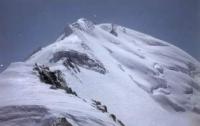
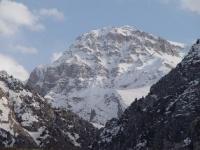
Glaciers of Zulumart Range.
Christian tourism in Tajkistan.
“Where I just did not fly by plane! I visited almost as many countries as my baggage"
Bob Hope.
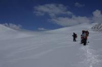
Short detour in Tajikistan.
Zulumart Ridge - one of the main Pidir watersheds is located in the Murghab region of the Gorno-Badakhshan Autonomous Region of Tajikistan. It departs from the highest part of the Zaalai Range in the area of Lenin Peak and stretches south to the Takhta-Korum Pass, 4,525 meters above sea level, separating the Muksu River Basin from the closed basin of Karakul Lake.
Large spurs extend from the Zulumart ridge: to the west, the broadly elongated Beleuli ridges and its branches, the Saukdar and Kaindy ranges, to the northeast - powerful, but less the long ridges of Kommunarov and Karachim.
The firn line rises from west to east from 4750 - 4800 to 5050 - 5100 meters above sea level. The border between the Western and Eastern Pamirs is usually drawn along the crest of the Zulumart ridge. On the Zulumart ridge and its spurs 509 glaciers with a total area of 410.0 square kilometers.
The large extent of the ridge, a complex system of spurs, the different nature of the ruggedness of the slopes and their exposure cause differences in the nature of glaciation. On the western slope of the Zulumart Range, there are 344 glaciers with an area of 287.1 square kilometers.
80% of the area is attributed to various types of valley glaciers, the remaining 20% to numerous ice, hanging and sloping glaciers. The glaciation of the western slope is characterized by the presence of large valley glaciers with well-developed feeding areas in the northern part of the ridge and in the areas of its junction with spurs, a decrease in the size of glaciers, a gradual transition to the eastern Pamir type of glaciation in the southern direction, and a noticeable predominance of glaciers on the slopes of northern exposures.
The largest glacier on the western slope of the Zulumart ridge - the Northern Zulumart glacier (11.6 kilometers long, 29.1 square kilometers) is located in the upper left tributary Sauksai River, in a deep hollow between the Zulumart ridge and the Beleuli ridge.
He gets several large tributaries with extensive feeding areas, and its wide end of the glacier flows north towards Bolshoi Saukdara glacier descending from the Zaalai ridge. At the end of the 30s, these glaciers merged, and currently the Northern Zulumart glacier has retreated by 4 kilometers.
On the northern slope of the Saukdar ridge, a continuous strip of firn fields feeds several complex and simple valley glaciers ranging in size from 3 to 11 square kilometers, and there are a total of 48 glaciers with a total area of 54.7 square kilometers.
On the steep southern slope of this ridge, there are only 7 glaciers with a total area of 5.0 kilometers square. Several valley glaciers ranging in size from 2 to 8.2 square kilometers are located on the northern slope of the Beleuli ridge.
At the junction of this ridge with the Saukdar ridge, at the bottom of an extensive circus, lies the complex Beleuli valley glacier (4.7 km long, 8.2 km2 square). It is formed from the confluence of a number of tributaries and, with a large feeding area, has a short tongue, a significant part of which is hidden under the moraine.
On the eastern slope of the Zulumart ridge, glaciation at the junction of this ridge with Zaalaysky is most significant. On the Zulumart mountain range, the right tributaries of the Oktyabrsky glacier begin, which is described in characterizing the glaciation of the Zaalaysky ridge.
ithout them, on the eastern slope of the Zulumart ridge, there are 165 glaciers with a total area of 122.5 square kilometers. Most of them belong to the basins of the Baigashka, Karadzhilga and Akdzhilga rivers of the Karakul lake basin.
On the whole, on the eastern slope of the Zulumart ridge there are approximately the same number of valley glaciers and slope glaciers, but the first of them account for more than 80% of the total glaciation area.
Valley glaciers most often occupy the headwaters of the main valleys of the eastern slope of the Zulumart ridge and the headwaters of the second order on the slopes of its spurs - the Kommunarov and Karachim ranges.
Parts of the largest glaciers occupy the entire bottoms of the valleys, descending to their mouths. Glaciers of northern exposure prevail. In the Akjilga river basin, on the eastern slope of the Karachim ridge, there are many small slope glaciers.
The largest glacier on the eastern slope - the Volodarsky glacier (9.3 kilometers long, 18.1 square kilometers) is located in the upper Baigashka River. It merges from three large streams with multi-chamber feeding areas.
In the lower part of the glacier, these flows are delimited by the shafts of the middle moraines. A wide part of the glacier ends at an altitude of 4,500 meters above sea level. To the east of the Zulumart ridge, the Karakul ridge with a typical East Pamirian relief stretches along the western shore of Lake Karakul.
Average height ridge 5200 - 5300 meters above sea level. There are 39 glaciers on the Karakul ridge with a total area of 20.6 square kilometers. Glaciers occupy gently sloping extended upper valleys and slopes.
There are approximately equal numbers of valley and slope glaciers. The surface of the glaciers is clean.
The total area of glaciation of the Zulumart Range is 460 square kilometers.
The largest glaciers of the Zulumart ridge and its spurs.
Glacier West October 13.6 kilometers long, an area of 18.4 square kilometers, located at an altitude of 4520 to 6710 meters above sea level, belongs to the Koksay river basin.
The 11.6-kilometer North Zulumart Glacier, an area of 20.1 square kilometers, located at an altitude of 4380 to 5830 meters above sea level, belongs to the basin of the Sauksai River tributary.
The Volodarsky Glacier, with a length of 9.3 kilometers, an area of 18.1 square kilometers, located at an altitude of 4500 to 5750 meters above sea level, belongs to a tributary of the Baigashka river basin.
Glacier 277 with a length of 8.4 kilometers, an area of 4.7 square kilometers, located at an altitude of 4460 to 5960 meters above sea level, belongs to the Koksay River Basin.
Glacier 282 with a length of 7.3 kilometers, an area of 3.9 square kilometers, located at an altitude of 4820 to 6600 meters above sea level, belongs to the Koksay river basin.
Glacier 314 with a length of 7.2 kilometers, an area of 11.1 square kilometers, located at an altitude of 4630 to 6030 meters above sea level, belongs to the basin of a tributary of the Sauksai River.
Glacier 272 and 273 with a length of 6.9 kilometers, an area of 10.5 square kilometers, located at an altitude of 4570 to 5440 meters above sea level, belongs to the Koksai River tributary basin.
Glacier 324 with a length of 6.5 kilometers, an area of 11.2 square kilometers, located at an altitude of 4900 to 5550 meters above sea level, belongs to the basin, a tributary of the Sauksai River.
Glacier 292 with a length of 6.0 kilometers, an area of 7.5 square kilometers, located at an altitude of 4650 to 5930 meters above sea level, belongs to the basin of a tributary of the Sauksai River.
Glacier 447 with a length of 6.0 kilometers, an area of 5.8 square kilometers, located at an altitude of 4440 to 5600 meters above sea level, belongs to the basin of a tributary of the Sauksai River.
Zulumart Glacier with a length of 5, 2 kilometers, an area of 5.1 square kilometers, located at an altitude of 4610 to 5720 meters above sea level, belongs to the basin, a tributary of the Sauksai River.
Glacier 514 with a length of 5.0 kilometers, an area of 4.7 square kilometers, located at an altitude of 4560 to 5200 meters above sea level, belongs to the basin of a tributary of the Zulumart River.
Glacier 328 with a length of 5.0 kilometers, an area of 3.4 square kilometers, located at an altitude of 4470 to 5730 meters above sea level, belongs to the basin of a tributary of the Sauksai River.
Glacier 254 with a length of 4.9 kilometers, an area of 3.5 square kilometers, located at an altitude of 4570 to 5650 meters above sea level, belongs to the inflow of the Baigashka River.
Glacier 241 and 242 with a length of 4.7 kilometers, an area of 3.0 square kilometers, located at an altitude of 4490 to 5540 meters above sea level, belongs to the basin of the Baigashka tributary.
Authority:
"Glaciers." L.D. Dolgushin, G.B. Osipova. Series "Nature of the world." Moscow, the publishing house "Thought". 1989.