


![]()
You are here
Glaciers of Zeravshan.
Tourist travel in Tajikistan.
"The sparkling, immaculate whiteness of the high mountain snows, untouched and perhaps unattainable; the beauty of the mountains shrouded in a misty haze that makes it impossible to discern whether they are earth or cloud; the distant, clear, impassive mountains - all this symbolizes the highest aspirations of the spirit. The universe appears to men in all its glory and grandeur, they are overcome with restlessness, the ancestral spirit of adventure awakens within them, and they depart... It is not conscious choice that makes men exchange comfort and security for adventure and adversity - rather, an impulse deeper and stronger than consciousness and reason is at work here."
Rockwell Kent.
Travel on Zeravshan mountains in Tajikistan.
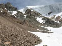
Zeravshan Glacier is located at an altitude of 3,290 meters above sea level (Kshymysh-Bash summit) and 2,831 meters above sea level. It lies between Turkestan Range to north and Zeravshan Range to south, in Sughd Region and districts of republican subordination.
Glacier belongs to the Zeravshan River basin. The largest glacier in the Gissar-Alai region, the Zeravshan Glacier, is located in the upper reaches of the Matcha River. It is 27.8 kilometers long, has an area of 132.6 square kilometers, and an ice volume of approximately 15 cubic kilometers.
It is a complex valley, silt-dendritic glacier consisting of a main stream and 20 tributary glaciers. The main source of the Zeravshan Glacier begins at the junction of the Turkestan, Alai, and Zeravshan Ranges. It flows initially south, then turns west near the Matcha Pass, 4,008 meters above sea level.
The firn area of this stream is relatively small, and the glacier receives its main supply from tributaries originating on the southern slope of the Turkestan Range. These are complex valley glaciers located in well-developed transverse valleys - the Farakhnau, Tolstova, Skachkova, Miramin, and other glaciers.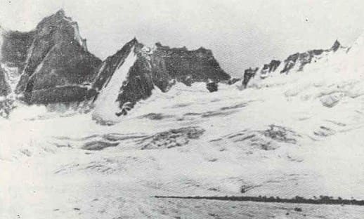
The left tributaries, descending from the northern slope of the Zeravshan Range, are small and steep. The relatively narrow (1.5 kilometers) and long section of the Zeravshan Glacier, with an average slope of approximately 8°, descends along a longitudinal valley between the Turkestan and Zeravshan Ranges to an altitude of 2,810 meters above sea level and ends in a cliff, from the grotto of which the Matcha River bursts forth as a turbulent torrent.
The glacier's surface is characterized by medial moraines and numerous ablative landforms. Gradually, the medial moraines merge, and the lower part of the glacier is completely covered by a moraine cover for 10 kilometers. Ice mounds covered by moraine are common here, with small lakes at their bases.
The rate of movement of the Zeravshan Glacier decreases from 20 - 25 centimeters per day at the upper part of the tongue to 0 centimeters per day at its end. The average thickness of the glacier is 200 meters. Since the end of the last century, the glacier has been retreating, with its right side, which receives more powerful tributaries, retreating more slowly than the left.
The glacier's long-term negative balance is also indicated by the separation of some tributaries and the overall subsidence of the surface, averaging 60 centimeters per year (Largest Glaciers. 1967). The two largest glaciers - Zerafshan and Preobrazhensky-Rama - occupy 53% of the total glaciated area on the southern slope of the Turkestan Range.
Valley glaciers, which comprise approximately 40% of the total glaciers, account for more than 80% of the total area. Two more glaciers have areas exceeding 5 square kilometers each, but most glaciers are small: 85% of all glaciers on the southern slope of the Turkestan Range are smaller than 1.1 square kilometers, accounting for approximately 20% of the total. 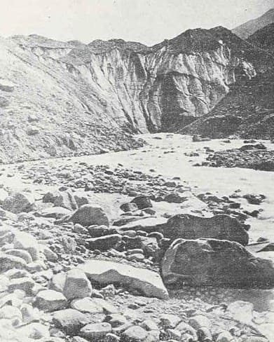
History of study of Zeravshan Glacier.
The glacier's moraines occupy 10 square kilometers, and together with its tributaries, 24 square kilometers. Observations of the Zeravshan River's discharge began at the Dupuli river gauge in the late XIXth century, and detailed observations of the Zeravshan Glacier began in 1927.
According to researchers, the glacier has been in a state of degradation throughout this period. Apparently, the glacier's tongue reached its greatest length and lowest position in the late XIXth century, as in 1927 the terminal moraine ridge was approximately half a kilometer from the glacier's end.
From 1927 to 1961, the glacier retreated 280 meters at an average rate of 8 meters per year, releasing 60 square kilometers. From 1961 to 1976, the glacier retreated 980 meters, an average rate of 65 meters per year, which is explained by the detachment and death of large ice masses.
From 1976 to 1991, the glacier retreated another 1,092 meters at an average rate of 73 meters per year. From 1927 to 1976, 1.19 square kilometers were released of ice, with 0.93 square kilometers since 1961 alone. Thus, the glacier is in a state of active degradation, with the rate of its retreat and the process of glacier destruction increasing with each decade.
Geographic coordinates of Zeravshan Glacier: N39°30'21 E70°36'04
Authority:
"Glaciers." L.D. Dolgushin, G.B. Osipova. Series "Nature of the world." Moscow, the publishing house "Thought". 1989.