


![]()
You are here
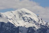
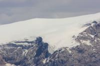
Glaciers of Turkestan Range.
Book local tours in Kyrgyzstan.
Kid, you'll move mountains”
Dr. Seuss. «Oh, The Places You'll Go!»
Vacation packages in Kyrgyzstan.
The total glaciated area of the Turkestan ridge is about 600 square kilometers. The height of the firn line on the northern slopes ranges from 3500 to 4000 meters above sea level, on the southern slopes - about 4500 meters above sea level.
Glaciers of Kshemysh, Shchurovsky, Minteke and others flow down from the northern slope of Turkestan. Almost all of them slide into deep gorges to the border of the forest. The southern slope of the Turkestan ridge is steeper, shorter and heavily dissected by rocky steep ridges.
Glaciers of Skachkov, Tolstov, Farakhnou and others are located between them. All of them merge with the huge flow of the Zeravshan glacier and carry masses of debris. The ridge of the Turkestan ridge, especially in the eastern part, is covered with mountain glaciers.
The largest are the Tolstoy, Shurovsky and Zeravshan glaciers - the source of the Zeravshan River.
Largest glaciers of Turkestan ridge.
Zeravshan glacier, 25 kilometers long, an area of 35 square kilometers, is located at an altitude of 2750 to 4900 meters above sea level, belongs to the Zeravshan river basin.
Farahnou glacier, 13.5 kilometers long, with an area of 19.8 square kilometers, is located at an altitude of 3080 to 5200 meters above sea level, belongs to the basin of the Zeravshan glacier.
Tolstov Glacier, 13.3 kilometers long, with an area of 17.3 square kilometers, is located at an altitude of 3200 to 5100 meters above sea level, belongs to the basin of the Zeravshan glacier.
Preobrazhensky glacier, 12.8 kilometers long, with an area of 20.6 square kilometers, is located at an altitude of 3100 to 4900 meters above sea level, belongs to the basin of the Rama Zeravshan glacier.
Shchurovsky glacier, 11.6 kilometers long, with an area of 21.1 square kilometers, is located at an altitude of 3280 to 5340 meters above sea level, belongs to the Dzhyptyk glacier basin.
Aksu glacier, 11.4 kilometers long, with an area of 17.4 square kilometers, is located at an altitude of 3280 to 5340 meters above sea level, belongs to the Aksu-Dzhaulaya river basin.
Mir-Amin glacier, 11.3 kilometers long, with an area of 13.8 square kilometers, is located at an altitude of 3640 to 5200 meters above sea level, belongs to the basin of the Zeravshan glacier.
Skachkov glacier, 9.7 kilometers long, with an area of 9.1 square kilometers, is located at an altitude of 3550 to 5100 meters above sea level, belongs to the basin of the Zeravshan glacier.
Kshemysh glacier, 9.6 kilometers long, with an area of 5.8 square kilometers, is located at an altitude of 3120 to 5020 meters above sea level, belongs to the Kshemysh-Isfara river basin.
Utren glacier, 8.9 kilometers long, with an area of 7.3 square kilometers, is located at an altitude of 2800 to 5000 meters above sea level, belongs to the Ak-Terek-Sokh river basin.
Aksu glacier II, with a length of 6.3 kilometers, an area of 6.5 square kilometers, is located at an altitude of 3400 to 5000 meters above sea level, belongs to the Aksu river basin.
Yarm glacier, with a length of 5.0 kilometers, an area of 4.3 square kilometers, is located at an altitude of 3680 to 4840 meters above sea level, belongs to the basin of the Zeravshan River.
Jumrut Glacier, 4.5 kilometers long, with an area of 1.4 square kilometers, is located at an altitude of 3440 to 4400 meters above sea level, belongs to the Jumrut River basin.
Berksu glacier, 3.7 kilometers long, with an area of 1.5 square kilometers, is located at an altitude of 3580 to 4480 meters above sea level, belongs to the Berksu river basin.
Sabakh glacier, with a length of 3.6 kilometers, an area of 5.5 square kilometers, is located at an altitude of 3760 to 4900 meters above sea level, belongs to the basin of the Zeravshan River.
Aktyubek glacier, with a length of 3.6 kilometers, an area of 3.1 square kilometers, is located at an altitude of 3670 to 4560 meters above sea level, belongs to the basin of the Urtachashma river.
Authority:
"Glaciers". L. D. Dolgushin, G.B. Osipova. Series "Nature of the World". Moscow, publishing house "Mysl". 1989.