


![]()
You are here
Glaciers of South-Alichur Range.
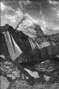
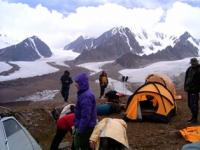
Photo tours in mountains of Tajikistan.
“Travels teach more than anything. Sometimes one day spent in other places gives more than ten years of living at home.”
France Anatole.
Lightweight hiking in Tajikistan.
The South-Alichur Ridge is an eastern continuation of the Shakhdara Ridge. It stretches from west to east from the Matz pass to the Istyk river. The crest of the main watershed is slightly dissected and is characterized by gentle rounded peaks.
The average height of the ridge in the western part is 5050 meters above sea level, in the eastern 5100 meters above sea level, the average height of the firn line is 5030 meters above sea level on the south slope and 5050 meters above sea level on the north.
There are 256 glaciers on the South Alichur ridge with a total area of 72.1 square kilometers. The glaciers are small (none exceeds 3 square kilometers), they are fairly evenly distributed along the main ridge of the ridge and its spurs.
On the southern slope of the South Alichur Range, there is 41 glacier with an area of 11.2 square kilometers. All glaciers are less than 1 kilometer square. These are mostly hanging glaciers, located mainly in shaded places.
The glaciation range is only 100 - 500 meters. The main glaciation is concentrated on the northern slope of the South-Alichur Ridge, 10 glaciers have an area of 1 to 3 square kilometers, there are valley glaciers (about 50% of the total glaciation area) with short parts ending at 4660 meters above sea level, but the most numerous are small slopes glaciers (51% of the total).
The surface of the glaciers of the South Alichur Range is characterized by the widespread development of other glaciers.
The total glaciation area of the South Alichur Range is 68 square kilometers.
The largest glaciers of the South Alichur Range.
The Urtabakchigir-2 Glacier, with a length of 7.0 kilometers, an area of 11.7 square kilometers, is located at an altitude of 4380 to 5600 meters above sea level, belongs to the basin of the Urtabakchigir-2 River.
The 5.6 km long Bakchigir Glacier, an area of 8.4 square kilometers, is located at an altitude of 4480 to 5350 meters above sea level, belongs to the Great Bakchigir River Basin.
The Urtabakchigir-1 Glacier, with a length of 5.0 kilometers, an area of 6.7 square kilometers, located at an altitude of 4380 to 5706 meters above sea level, belongs to a tributary of the Urtabakchigir-1 river basin.
Glacier 385, with a length of 3.9 kilometers, an area of 2.1 square kilometers, located at an altitude of 4560 to 5550 meters above sea level, belongs to the basin of the North Aktaylyak River.
Glacier 459, with a length of 3.4 kilometers, an area of 2.9 square kilometers, located at an altitude of 4600 to 5450 meters above sea level, belongs to the basin of the Western Gurumdy River.
Glacier 445, with a length of 3.4 kilometers, an area of 2.7 square kilometers, located at an altitude of 4700 to 5250 meters above sea level, belongs to the basin of a tributary of the Upalysay River.
Glacier 426, with a length of 3.0 kilometers, an area of 1.6 square kilometers, located at an altitude of 4600 to 5350 meters above sea level, belongs to the tributary of the Aksai river basin.
Glacier 341, with a length of 2.7 kilometers, an area of 1.3 square kilometers, located at an altitude of 4840 to 5100 meters above sea level, belongs to the Zorkorumdy river basin.
Glacier 456, with a length of 2.6 kilometers, an area of 2.3 square kilometers, located at an altitude of 4780 to 5350 meters above sea level, belongs to the Mionazhkul river basin.
Glacier 463, with a length of 2.6 kilometers, an area of 2.2 square kilometers, located at an altitude of 4640 to 5200 meters above sea level, belongs to the basin of the tributary of the Kotarazhkul River.
Glacier 405, with a length of 2.6 kilometers, an area of 1.7 square kilometers, located at an altitude of 4780 to 5580 meters above sea level, belongs to a tributary of the South Aktaylyak river basin.
Glacier 363, with a length of 2.5 kilometers, an area of 2.6 square kilometers, is located at an altitude of 4700 to 5600 meters above sea level, belongs to the basin of the Gorumdy River.
Authority:
"Glaciers." L.D. Dolgushin, G.B. Osipova. Series "Nature of the world." Moscow, the publishing house "Thought". 1989.