


![]()
You are here
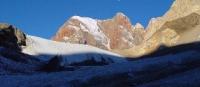
Glaciers of Darvaz ridge.
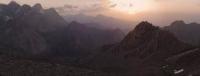
Rambler on Pamir in Tajikistaan.
“On any long road,
No matter how hard the path
I remembered this rocky
Kichkinekol Pass»
Yuri Vizbor. December 1954.
Travel advisory in Tajikistan.
The Darvaz Range extends from the Garmo peak in a southwestern direction, first along the Vanch River Valley, and then along the Pyanj River, following its bends, its length is more than 162 kilometers. The administrative border between the Gorno-Badakhshan Autonomous Region and the Sangvor District of the Republican Subordination of Tajikistan runs along the Darvaz Range.
The section of the ridge ridge adjacent to the ridge of the Academy of Sciences has an average height of 5840 meters above sea level, the rest of the ridge is 4950 meters above sea level, and only Arnavad peak at a height of 6080 meters above sea level stands out sharply against this background.
The southern slope of the ridge, facing the valley of the Vanch River, is steep, with short massive spurs. The northern slope is strongly dissected by the river valleys - the left tributaries of the Obihingou River, and large spurs - the Pashimgar, Mazarsky and Darkharvak ranges - depart from it.
In total, there are 551 glaciers with a total area of 520.3 square kilometers on the Darvaz ridge (without the Garmo glaciers and the Russian Geographical Society attributed to the Academy of Sciences ridge). The bulk of the glaciers is small: 81% of all glaciers are no larger than 1 kilometer square.
Glaciers exceeding 5 square kilometers in area are only 18, but they make up almost 40% of the area of glaciation on the ridge. Moreover, all of them, except for two, are located on the northern slope of the ridge in the Obihingou river basin.
There are 324 glaciers on the northern slope of the Darvaz Range, with a total area of 365.7 square kilometers, which is 2.3 times larger than the glaciation area of the southern slope. Both the number (70%) and the area (96%) are dominated by valley glaciers, their size and number increase from west to east with an increase in the height of the mountains.
The firn line rises from 3900 - 4000 meters above sea level in the western part of the ridge to 4500 - 4600 meters above sea level in the upper Obihingou River. The largest glaciers of the Darvaz Range are located in the upper reaches of the Obimazar River - these are the glaciers of Darvaz and Mazarsky.
Both are characterized by relatively small firn basins and a significant role in feeding the avalanches and landslides of firn from the slopes.
The glacier of Darvaz is located in the Sangvor region of Tajikistan. The length of the glacier is 16.2 kilometers, the area of the Darvaz glacier is 27.8 kilometers square - a complex valley glacier, the main trunk of which is formed from 5 small streams starting on steep slopes in the upper valleys.
The feeding area of its large right tributary is connected with the firn area of the Sed glacier on the southern slope of the ridge, and the tongue flows along a narrow steep valley and is broken by cracks almost until it merges with the main glacier.
The Mazorsky Glacier is located in the Sangvor region of Tajikistan, at the head of the Ob-Mazar River, a large left tributary of the Obihingou. It flows from the northern slope of the Darvaz Range. The length of the glacier is 16.8 kilometers, the area of the Mazorsky glacier is 23.0 square kilometers, originating from the firn plateau in the crest of the Darvaz Range, common with the Sed glacier.
The glacier is located in a narrow deep valley, elongated along the Mazor Range. Most of the surface of the tongue is covered with moraine. The glacier ends at an altitude of 3200 meters above sea level, wedging itself into the zone of woody and shrubby vegetation.
Several large complex valley glaciers lie in the upper reaches of the Bochud River - the Burs, Sytargi and Zordi-Birauso glaciers. They have extensive multi-chamber nutrition areas and wide moraine parts with hilly karst relief at the ends of the glacier.
58 glaciers with an area of 97.4 square kilometers are located on the northeastern slope of the Mazar Range (average altitude 5500 meters above sea level). Of these, the largest is the Bartrut Right glacier. It has an extensive high elevated feeding area and a wide portion.
Before entering the extension of the valley, the glacier is torn apart by a high rocky step, below which a new glacier is formed, about 2 kilometers long, almost completely covered by moraine. The height of the end of the glacier is 3200 meters above sea level.
Glacier observations began in 1958. From 1958 to 1976, the glacier retreated 210 meters, an average of 10 meters per year, freeing 0.11 kilometers of ice from ice. From 1975 to 1990, he retreated another 261 meters at a speed of 16.3 meters per year.
From 1987 to 1990, he retreated another 40 meters at a speed of 13 meters per year, freeing up 0.019 square kilometers.
The Skogach Glacier is located in the Sangvor region of Tajikistan. The length of the glacier 12 The Skogach Glacier is located in the Sangvor region of Tajikistan. The length of the glacier is 12 kilometers, the area of the Skogach glacier is 12.6 square kilometers.
The glacier is located in the Obihingou River Basin on the northern slope of the Mazarsky Range, which is a large spur of the Darvaz Range. The Skogach River flowing out of the glacier flows into the Bochud River.
Skogach is a valley glacier, the volume of ice is 1.2 kilometers cubic. The glacier is located at an altitude of 3050 meters above sea level. Moraine covered 1.1 kilometers square surface of the glacier. The firn area of this typical valley glacier is located in vast valleys, and the long part of the glacier descends through a narrow deep valley to an altitude of 3050 meters above sea level.
At an altitude of 4000 - 4200 meters above sea level is an impenetrable icefall with a length of about 2 kilometers. The lower part of the glacier is covered with moraine. The speed of ice movement is about 42 centimeters per day, in the middle part of the glacier 10 centimeters per day and near the end of the glacier.
During the ablation period, the glacier melts about 3 meters of ice (Sannikov, Yablokov. 1974). Since 1969, for many years, glaciological observations by Glavtadzhikgidromet specialists have been carried out on the glacier.
The total retreat of the Skogach Glacier from 1969 to 1976 was 76 meters, an average of 11 meters per year. From 1975 to 1991, he retreated another 67 meters at an average speed of 4.2 meters per year. However, only in 1991 he retreated immediately to 10 meters.
During the period from 1969 to 1986, the glacier lost 98.8 million meters of cubic ice, which is 8.2% of its total mass, on average 0.5% of the mass per year. In the headwaters of the Darharvak River, where the Darharvak complex valley glacier lies, the Darvazskii ridge sharply turns to the northwest, its height decreases to 4,500 meters above sea level, and glaciation is gradually weakening.
Along the left bank of the Darharvak River and in the basins of the left tributaries of the Obihingou River, there are small valley glaciers with an area of 2 to 4 square kilometers and caravans, mostly with moraine-covered parts.
The steep and short southern slope of the Darvaz Range above 4000 meters above sea level becomes gentle. The gorges of the right tributaries of the Vanch River in the upper reaches sharply expand, erosion valleys give way to vast ancient valleys, often elongated along the ridge.
On their slopes are groups of modern glaciers. The firn line height increases with west to east from 3800 to 4400 meters above sea level. On the southern slope of the Darvaz Range, in the Vanch river basin, 124 glaciers with an area of 101.6 square kilometers.
There are approximately the same number of glacial valleys and slopes, but the area of the valleys is much larger (81%). There are few large glaciers. The largest is the Komsomolets glacier (12.2 kilometers long, 17.9 square kilometers) - a former tributary of the Geographical Society glacier.
To the west of it, on the slopes of ancient circuses, lie small valley, valley glaciers. In the region of Arnavad Peak, 6,080 meters above sea level, there are several valley glaciers 2.5 to 3 kilometers square in size and Sed Valley Glacier (11.6 kilometers long, 7.2 kilometers square) with two feeding areas: one on the slope of the peak Arnavad, the second is a flat firn plateau in a separate part of the ridge, which also feeds the glaciers of the northern slope.
From this plateau, through a hole in the crest of the ridge, a long and narrow glacier descends to an altitude of 2900 meters above sea level, the end of which is covered with moraine. Almost all the glaciers of the southern slope of the Darvaz Range are abundantly covered with moraine material.
In some caravans, the clear surfaces of firn and ice are preserved only near the slopes, and parts of the glaciers are completely hidden under moraines. On the southwestern slope of the Darvaz Range, from which the right tributaries of the Panj River originate, 103 glaciers have an area of 53.0 square kilometers.
Of these, more than half are small caravan and hanging glaciers (36% of the total area). 64% of the area is in valley and small valley glaciers. 13 glaciers are larger than 1 square kilometers, the largest - 3 square kilometers.
The average height of the firn line is about 4000 meters above sea level, the ends of glaciers - 3800 meters above sea level.
The total area of glaciation of the Darvaz Range is 420 square kilometers.
The largest glaciers of the Darvaz Range.
The Glacier of the Geographical Obchestva, with a length of 23.6 kilometers, an area of 28.2 square kilometers, located at an altitude of 2580 to 6200 meters above sea level, belongs to the Vanch River Basin.
The Mazarsky Glacier (2 branches), with a length of 16.8 kilometers, an area of 23.0 square kilometers, located at an altitude of 3200 to 5400 meters above sea level, belongs to the Obimazar and Obihingou river basins.
The Darvaz Glacier (2 branches), with a length of 16.2 kilometers, an area of 27.8 square kilometers, located at an altitude of 2950 to 5800 meters above sea level, belongs to the Gobimazar and Obihingou rivers.
Vavilov Glacier, with a length of 12.5 kilometers, an area of 22.0 square kilometers, located at an altitude of 3550 to 5880 meters above sea level, belongs to the Garmo River Basin.
The Komsomolets Glacier, with a length of 12.2 kilometers, an area of 17.9 square kilometers, located at an altitude of 3260 to 5930 meters above sea level, belongs to the Vanch River Basin.
The Batrut Glacier (2 branches), with a length of 12.0: 9.3 kilometers, an area of 23.2 square kilometers, located at an altitude of 2980 to 5800 meters above sea level, belongs to the basin of the Batrut and Obihingou rivers.
The Skogach Glacier, with a length of 12.0 kilometers, an area of 12.6 square kilometers, located at an altitude of 3050 to 5250 meters above sea level, belongs to the basin of the Skogach and Bohud rivers.
The Shokalsky Glacier, with a length of 12.0 kilometers, an area of 17.4 square kilometers, located at an altitude of 3,500 to 5,680 meters above sea level, belongs to the Garmo River Basin.
The Sed Glacier, with a length of 11.6 kilometers, an area of 7.2 square kilometers, is located at an altitude of 2900 to 5700 meters above sea level, belongs to the Daraised and Vanch rivers.
The Vanchdara Glacier, with a length of 9.5 kilometers, an area of 6.9 square kilometers, located at an altitude of 3870 to 5400 meters above sea level, belongs to the basin of the Muumbni and Garmo rivers.
The Zordi-Birauso Glacier (4 branches), 9.4 kilometers long, covers an area of 18.3 square kilometers, located at an altitude of 3280 to 5400 meters above sea level, belongs to the Zordi-Birau and Bochud river basins.
The Darharvarvak glacier (5 branches), with a length of 6.9 kilometers, an area of 12.1 square kilometers, located at an altitude of 3960 to 5280 meters above sea level, belongs to the basin of the Darharvak and Obimazar rivers.
The 4.4 km long Bunai Glacier, an area of 2.0 square kilometers, located at an altitude of 3100 to 4700 meters above sea level, belongs to the Daraibunai and Vanch rivers.
Authority:
"Glaciers." L.D. Dolgushin, G.B. Osipova. Series "Nature of the world." Moscow, the publishing house "Thought". 1989.
Photos by
Alexander Petrov.