


![]()
You are here
Glacier Northern Inylchek. Kyrgyzstan.


Hiking to Glacier Northern Inylchek.
“What are men to rocks and mountains?”
Jane Austen. «Pride and Prejudice».
Travel to mountains the Southern Kazakhstan.
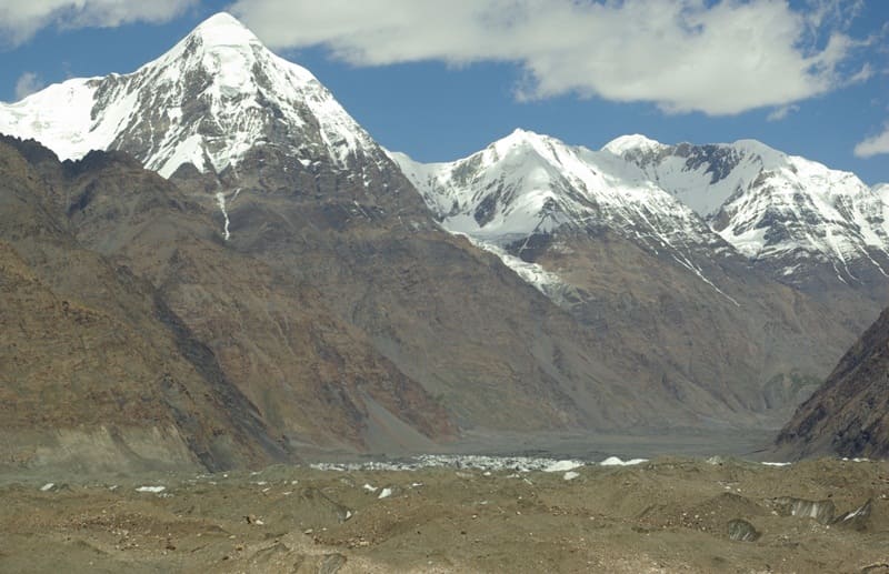
The North Inylchek glacier (North Engilchek or Reznichenko glacier; Kirgh. Tunduk Ehilchek) is located between the Tengri Tau ranges in the south and the Saryjaz ranges in the north in the Ak-Suu district of the Issyk-Kul region.
Northern Inylchk is a complex valley glacier located in the mountains of the Central Tien Shan, in the upper reaches of the Inylchek River, which is a left tributary of the Sarydzhaz River. The total area of the glacier is 203 square kilometers, of which 17 square kilometers are located on the territory of the Republic of Kazakhstan.
The glacier recharge area is located at altitudes up to 7000 meters above sea level. The firm line is located at an altitude of 4750 meters above sea level. In 1996, the movement of the glacier almost completely destroyed Lake Superior, which was located east of Lake Merzbacher.
Between the end of the North Inylchek glacier and the lower part of the South Inylchek glacier, there is Lake Mertsbacher. The tongue of the North Inylchek glacier is located at an altitude of 3350 meters above sea level.
18 glaciers take the left side of the North Inylchek glacier from the northern slope of the Tengri tau ridge. 21 glaciers descend and join the right side of the glacier from the southern slopes of the Saryjaz ridge. Some side glaciers do not reach the main ice stream.
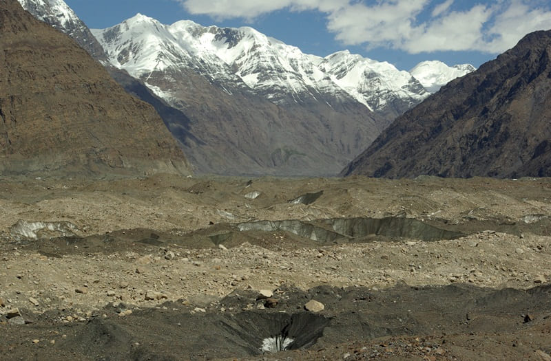
Cracks are developed in the firn area of the glacier for 7 kilometers. The glacier protrudes from the firn area with a gentle ledge and fills the entire valley. Its surface is smooth, slightly convex. From the Karly Tos glacier to the middle of the glacier, there is a small channel of a water stream, on both sides of which two middle moraines appear.
Below the surface of the tongue is replete with cracks, and at the level of Khan-Tengri peak it becomes hilly, the height of the ice hills reaches 30 meters. Farther still, the entire lower part of the glacier, to the very end, is a disorderly heap of glacial blocks with scattered hollows and sinkholes.
The middle moraines, gradually expanding, leave an area of pure ice 0.8 kilometers wide. At 12 kilometers from the end of the glacier, the middle moraines converge, the glacier here is covered with a continuous moraine cover.
The right lateral moraine, starting at the foot of the Khan-Tengri peak, stretches to the end of the glacier, and along this length the glacial body is separated from the side of the valley by a hollow, the width of which in the lower part is about 200 meters.
On the left side, the glacial body adheres tightly to the side, the lateral moraine is insignificant. The origins of the glacier are located on the western slope of the Meridional ridge in the ridge, which peaks are located: the Marble Wall, 6140 meters above sea level, the peak of the 100th anniversary of the Russian Geographical Society, 6276 meters above sea level, and the Plato peak, 5850 meters above sea level.
The tongue of the glacier is located at an altitude of 3350 meters above sea level at its confluence with the South Inylchek glacier. The upper part of the glacier, for 11 kilometers, is located in the Narynkol district of the Almaty region.
From the Mramornaya Stena peak to the state border between the Republic of Kazakhstan and the Kyrgyz Republic, which runs from the top of Khan-Tengri peak to the north-west to the top of Semenov. The border is crossed by the North Inylchek glacier at an altitude of 3984 meters above sea level.
The rest of the glacier is located in the Ak-Suu region of the Issyk-Kul region of Kyrgyzstan. The length of the North Inylchek glacier along the territory of Kazakhstan from the wall of the Marble Wall to the border with Kyrgyzstan is 11 kilometers.
The total length of the North Inylchek glacier is 42 kilometers, including the length of the glacier that starts from the western slope of the Mramornaya Stena peak (11.2021) and the seasonal Merzbacher lake. In the north, the North Inylchek glacier borders the Sarydzhaz mountain range, on the south side, the Tengri tau ridge.
On the eastern side, the glacier is surrounded by the Meridional ridge. Snowy peak The Marble Wall from the west is decorated with a kilometer-long wall of black and yellow marble, with a huge ice cap hanging from above.
Geographic coordinates of the North Inylchek glacier: N42 ° 14'26.60 "E80 ° 04'19.91"
Authority:
Alexander Petrov.
https://www.open.kg/about-kyrgyzstan/nature/mountains-and-glaciers/glaciers/34153-ledniki-yuzhnyy-i-severnyy-inylchek.html
Photos by
Alexander Petrov and Vladimir Serbenko.