


![]()
You are here
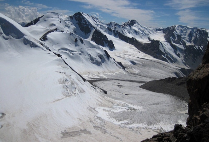
Glacier of Korzhenevsky.
.")
Kazakhstan mountains Tours.
“Why do you go away? So that you can come back. So that you can see the place you came from with new eyes and extra colors. And the people there see you differently, too. Coming back to where you started is not the same as never leaving”
Terry Pratchett. “A Hat Full of Sky”.
Guided Natural Tours in Almaty.
The Korzhenevsky glacier is located at an altitude of 4878.9 (the height of the highest peak of the Northern Tien Shan, Talgar peak) to 3287.2 meters above sea level, located in the Talgar mountain range, belongs to the Chilik river basin, on the southeastern slope of the Zailiysky Alatau mountain range in the mountain system of the Northern Tien-Shan, on the territory of the Almaty reserve in the Almaty region.
The Korzhenevsky glacier is the largest in the Trans-Ili Alatau. It occupies a vast area at the headwaters of the South Issyk River between the South Issyk spur and the main ridge, enveloping the glacier from the rear and left side.
The Korzhenevsky glacier is a valley glacier, it feeds on snow from the highest part of the main ridge, where Talgar peak is located almost in the center of its rear. The average height of some of the mountains bearing the firn fields of the glacier is approximately 4500 meters above sea level.
The open end of the tongue descends to an altitude of 3300 meters above sea level. The vertical distance between the highest and lowest points of the glacier reaches 1717 meters above sea level. The glacier is about 11.2 kilometers long; the area is about 38 square kilometers.
The upper reaches of the glacier are located in four firn basins, of which the outermost ones are the largest. Their view, together with the bulk of the surrounding mountains, is the most majestic in the entire Zailiyskiy Alatau.
All the back walls of the circuses represent a continuous snow field, inclined at angles of 25-30 degrees and in places torn apart by the weight of the heavily settled masses. (“Glaciation of the Tien Shan”. 1995). Each of the firn pools gives its own branch to the glacier.
The two middle branches start from four chambers from the Talgar peak. They are short and 300 - 350 meters wide. Both, upon leaving the circuses, soon merge into one. The left branch, which is up to 8 kilometers long and more than 1 kilometer wide, departs from the Kopyr and Metallurg peaks.
Having an initial direction to the southeast, it gradually makes an arcuate turn and, with an exposure to the south, approaches the middle branch, from which in the upper reaches it is separated by a spur that separates from the East Talgar summit.
From the end of this spur, the left median moraine stretches along the glacier. The right branch, which has a length of up to 5 kilometers and a width of up to 4 kilometers, originates from the slope of the main ridge facing the east, where two completely snow-covered peaks with heights of more than 4600 meters at sea level stand out: in the south-western corner is the peak of Vseobuch (4650 meters above sea level), from which the Issyktekshoku spur begins, and in the center is the White peak peak.
Initially, the branch flows eastward, where, upon encountering a lateral spur, it turns southward. The width of the glacier at the confluence of all branches reaches 4 kilometers, then it gradually decreases. In the lower reaches of the tongue, it is already 700 - 800 meters.
The surface of the glacier in the longitudinal direction has an inclination angle of more than 7 degrees. In some places, especially near the firn line, it is cut with cracks, which form a labyrinth in the upper part of the right branch, and icefalls on the left branch. In some places there are glacial mills and wells. (Gorbunov, 1939).
The glacier in the upper part of the stream carries four median moraines. Two of them then merge into one. The main stream of melt water rushes violently along the tongue of the glacier in a deep canyon. At the south-facing end, the tongue of the glacier becomes steep and splits across its entire width into a series of ledges.
The rest of the glaciation area in the South Issyk basin is represented by 12 small glaciers with a total area of about 10 square kilometers. Of these, eight glaciers are located on the eastern slope of the South Issyk spur.
All of them belong to the tar type, facing east and northeast, to the right side of the Korzhenevsky glacier. Two larger ones (up to 1.5 kilometers long) emerge from the cars and enter narrow “suspended gorges, forming hanging tongues in them with a very steep fall.
Four glaciers are located on the western slope of the main ridge and its spur, located south of the Kokbulak summit. They have a southwestern exposure and face the left side of the Korzhenevsky glacier. All these glaciers are tarry, up to 1.5 kilometers long.
Their ends, framed by moraine deposits, lie in short gorges of the slope and do not reach the main glacier. The glacier begins in the highest part of the ridge at Talgar summit 4974 meters above sea level - the highest point of the Zailiyskiy Alatau.
The tongue of the glacier ends, bifurcating, at an altitude of 3450 meters above sea level, the firn line runs at an altitude of 3950 - 4000 m. From 1959 to 1965, the glacier retreated by 89 meters, that is, by 14.8 meters per year.
The glacier is named in honor of the explorer of Central Asia, geographer N. L. Korzhenevsky (1879 - 1958) who discovered the glacier in 1928. Soviet geographer, glaciologist, doctor of geographical sciences, honored worker of sciences of the Uzbek SSR, corresponding member of the Academy of Sciences of the Uzbek SSR. Professor, Head of the Department of Physical Geography, Central Asian University.
Geographic coordinates of the Korzhenevsky glacier: N43 ° 05'53.85 "E77 ° 23'16.13"


Authority:
"Glaciers." L.D. Dolgushin, G.B. Osipova. Series "Nature of the world." Moscow, the publishing house "Thought". 1989.
Photos by
Alwxander Petrov, Roman Stesenko.