


![]()
You are here
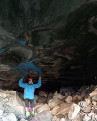
Glacier cave Oktyabrskaya.
Glacier caves in Trans-Ili Alatau mountains.
“I will touch the mountains with a word,
I'll take off the remnants of summer colors
And I will dedicate the landscape to poetry
From the rhymes of seasonal upheavals.
I will touch the streams with sound,
I'll film the fall of the waterfalls
And I will join him to the stones
own the rushing cascade."
Victor Storopov.
Sights of Bogdanovich glacier in Zailiskiy Alatau.
Oktyabrskaya cave is located at an altitude of 3300 meters above sea level, located on Bogdanovich glacier in the Maloalmatinsky spur, on northern slope of Zailiysky Alatau ridge in Medeu district of Almaty.
The Oktyabrskaya Cave is a horizontally inclined cavity, flooded in summer and dry in winter. The cave has two horizons - upper and lower. The name “Oktyabrskaya” was given to it by members of the Kazakh Republican Section of Speleotourism, who opened it in October 1963.
To get to the cave from the Bolshoy Talgarsky pass, you need to turn right into the cirque of the Bogdanovich glacier and continue moving to the border of the open and buried parts of the glacier. Currently, five entrances to the Oktyabrskaya cave are known.
Entrance No. 1 is located in the middle part of the glacier at the bottom of the depression separating the open part of the glacier from the buried one. It is a channel in the ice, gradually turning into an under-ice passage.
Entrance No. 2 is located in the western part of the mentioned depression, slightly higher than entrance No. 1. It is a slotted hole, extended along the course of the cave from northeast to southwest, 4 meters long, 0.5 meters high.
Entrance No. 3 is located 50 meters south of the glacial lake in an ice outcrop on the northern slope of the moraine ridge. It has the shape of an arch, 1.5 meters wide and 0.7 meters high. Entrance No. 4 is located 30 meters east of the lake in an outcrop of ice on the steep slope of the moraine ridge bordering the lake on the east.
Just like entrance No. 3, it faces north. It represents the beginning of a passage leading obliquely down into the depths of the glacier. The width of entrance No. 4 is 1.5 meters, the height is 2 meters. Entrance No. 5 is a gap under a granite block, facing south.
The width of the gap is 1.5 meters, the height is 0.5 meters. The entrance is located 200 m northeast of the glacial lake, on the right side of a ravine that stretches along the body of the glacier east of the lake from south to north.
The total length of the cave passages is 1390 meters, the length of the main passage (the path of the summer stream) is 1300 meters, the depth of entrance level No. 3 is 118 meters. The shape of the cross-section of the cave passage depends on the conditions of occurrence of one or another of its parts.
The passage running through a continuous mass of ice has a high cross-section tapering upward. The average width of such a passage is 1 - 1.5 meters, the average height is 6 - 8 meters, but sometimes reaches 12 meters (at entrance No. 3).
In this part of the cave there is practically no ceiling. The walls of the passage, approaching upward, form a gradually wedged gap, which is often not visible from the bottom of the passage. On the lower horizon, where the cave reaches the bottom moraine of the glacier, the passage has a cross section that is highly elongated horizontally.
The stroke height is reduced to 0.5 m, the width increases to 8 - 10 meters. The floor area of the cave is about 1400 square meters, the volume of the cavity is 7000 cubic meters. The cave is divided into two parts (upper horizon and lower horizon) by a 25-meter plumb line located at entrance No. 4.
here are almost no signs of slope in the upper and first half of the lower horizons. The second half of the lower horizon has a pronounced slope. In this regard, the upper horizon and the first half of the lower horizon have steep meanders - meanders.
The significant slope of the second half of the lower horizon determined a more straightened configuration of the passage in this part of the cave. The cave is embedded in the body of a glacier; the passage lies in the thickness of buried ice throughout almost its entire length.
Only at the lower horizon does the course reach the bottom moraine. This is responsible for the flattened cross-sectional shape of the passage in this section. If in the thickness of the ice a summer stream, intensively eroding its bed, goes deeper down, then, having reached the blockage of granite blocks, the stream cannot erode and deepen the bottom.
Therefore, it erodes the side ice walls, forming a wide but low passage. Bottom moraine in the place of contact with the cave has a slope to the west; the flow erodes the ice at the contact point, bending the moraine outcrop to the left, and gradually moves along the slope of the moraine to the west.
The floor of the cave is flat and smooth throughout. Freezing of the flow in the upper horizon and at the beginning of the lower horizon of the cave is usually accompanied by the formation of an upper thin crust of ice, several millimeters thick, and numerous voids under the upper crust.
This structure of the cave floor is observed to a depth of 20 – 25 cm below which the bedrock ice of the glacier begins. The upper crust of ice on the floor of the passage, as a rule, does not support the weight of a person and falls through. There was a case (1963) of a stream freezing inside a cave as a continuous mass, without the formation of voids.
The stream exists in the cave during the summer season (May–October), fed by meltwater. Its flow rate, measured on August 9, 1964 at 11 o'clock in the afternoon at entrance No. 3, was 330 liters per second. Water enters the cave through entrance No. 1, located at the bottom of the depression, into which streams flow from the open part of the glacier and the nearby peaks of the cirque.
During the period of the most intense melting (June–July–August), a lake is formed at the bottom of the depression, which drains through the Oktyabrskaya cave. Melt water penetrates into the cave in different places along its entire length (for example, at entrances No. 3 and No. 5).
Thus, the cave is probably the main drainage route for meltwater from the circus of the Bogdanovich glacier. The outflow flowing in the cave intensively erodes its ice bed. During the summer season of 1964, the bottom of the cave dropped by 35 cm at entrance No. 3, and by 1 meter at the end of the upper horizon.
The configuration of the steep section connecting the upper and lower horizons has radically changed. These facts indicate rapid melting of ice. Compared to classic and karst cavities, changes in ice caves. The nature of their change is probably influenced by three main factors; constant movement downhill of the glacier body; seasonal intense erosion of the passage; constant narrowing of the cave passage under the pressure of the surrounding mass of ice.
The latter process is clearly expressed in the form of cross sections of the cave passage. In most cases, these sections resemble a tall, narrow crack, the walls of which gradually converge upward. On November 8, 1963, in the absence of melting in the glacier circus and the flow of water on the upper horizon of the cave, the sounds of flowing water were clearly heard from the lower horizon at entrance No. 4. This phenomenon is probably explained by the presence of a lake near the cave, located on the surface of the glacier.
The lake is a collector of part of the meltwater flowing from the surface of the glacier during the summer season, and holds about 1,500 cubic meters of water. At entrance No. 4, the cave passage comes almost close to the eastern edge of the lake.
Probably, the lake has a flow into the lower horizon of the cave, therefore, during the period of practical absence of thawing, the water reserve accumulated in it during the season is a source of maintaining the flow in the lower horizon for 3 - 5 days after the cessation of thawing and the disappearance of the flow in the upper horizon.
On December 5, 1963, no flowing water was found on the lower horizon. Throughout the entire length of the cave, at the bottom of the passage near the walls, and especially on the side ledges of the passage, located at a small height from the bottom, deposits of sand and small gravel were found.
The largest amount of sediment was found at the beginning and end of the lower horizon. The cave is rich in sinter ice formations. An abundance of ice stalactites and columns was observed in March 1965 along 200 meters at the end of the cave.
A significant part of the stalactites on the columns had a clearly expressed eccentric shape; Many stalactites, while symmetrical in shape, had inclinations of up to 60 degrees to the horizon. Visits to the cave are possible in winter (November - March), since in summer a stream of melt water flows inside the cavity and constant melting inside the passage creates the danger of landslides and rockfalls.
In winter, the cave is accessible to unprepared groups of tourists, but participants must undergo a medical examination. The descent to the lower horizon of the cave can only be made for trained groups under the guidance of an experienced instructor if the group has the necessary special equipment.
The first three entrances to the cave are accessible without safety equipment. Descent and ascent through the fifth entrance requires a top rope; Entering the cave through Entrance 4 requires a ladder and a top rope.
The complete passage of the cave is classified as a descent of 3A difficulty category. A visit to the upper horizon of the cave is a descent of the first category. The following routes have category 2A difficulty:
a) descent through entrance 5, passage of the lower horizon, ascent through entrance 5;
b) descent from the upper horizon to the lower one, ascent through entrance 5.
Geographic coordinates of Oktyabrskaya glacier cave: N43°05'58 E77°06'34


Authority:
V. Poluektov.
https://soumgan.com/phpBB2/viewtopic.php?f=14&t=65&sid=0b3e3a16c5cc3505baa363136c38cef0
Photos by:
Dina Ibragimova.