


![]()
You are here
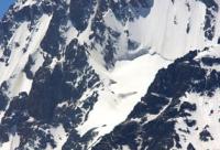
Glacier Adygeneter.
Tourist travel to Ala-Archa gorge.
"Hello! I have come to you again,
To tell you kind words.
I came here, done with business,
Take a look at the mountains in the evening.
Talk eye to eye with the river,
Find out how the grass feels
And leaving behind the forest,
Bow down to this heaven."
Yuri Vizbor. 1957.
Climbing peaks in Ala-Archa gorge.
The Adygenetar glacier is located on the northern slope of the Kyrgyz ridge, in the Testor gorge belonging to the Ala-Archa river basin, 41 kilometers southwest of the city of Bishkek in the Alamudun district of the Chui region.
The length of the open part of the glacier is 1.3 kilometers, the closed, moraine part is 600 meters. The perimeter of the open part of the Adygenetter glacier is 2647 meters, the area is 251462 square meters. The sources of the glacier are located on the northern slopes of the Adygene peak, 4393,4 meters above sea level, which is located in the ridge dividing the Panfilov glacier.
The tongue of the open part of the glacier is located at an altitude of 3836 meters above sea level, the tongue of the closed part of the glacier is located at an altitude of 3579 meters above sea level, almost in the bed of the Testor River. In the eastern part of the Adygener glacier, behind a small ridge, there is a small, unnamed glacier 650 meters long.
The moraine of this glacier stretches for 1.5 kilometers. At an altitude of 3579 meters above sea level, the moraine part of the Adygenetter glacier is in contact with the moraine part of the unnamed glacier. A small glacier descends from the western slope of the Adygene peak into the valley of the Dzhelamysh river.
Geographic coordinates of the Adygenetter glacier: N42 ° 32'04.61 "E74 ° 24'57.70"
Authority and photos by
Alexander Petrov.