


![]()
You are here
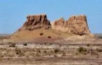
Fortress Malaya Kyrk kyz kala.
Travel to monuments of Karakalpakstan.
“After the end of the excavations, we entered a new, one of the most difficult exploration routes of our expedition - the North Karakum route. Our caravan of 14 camels set out on a clear October morning from the capital of northern Turkmenistan - the city of Tashauz - to the west.
In two weeks, we walked about 150 kilometers along a huge ancient canal - the main highway of the "lands of ancient irrigation" of southwestern Khorezm and further, deep into the sands to the ruins of Dev-Kala, and examined 12 monuments of the ancient and medieval era, from the middle of the Ist millennium to n. e. until the XIV century. n. e. ".
Tolstov S.P. "In the footsteps of the ancient Khorezm civilization." 1937 - 1945
Archaeological monuments of Karakalpakstan.
The Malaya Kyrk kyz kala fortress ("forty girls") is located in the southern part of the Ayazkol salt marsh, in the northern part of the Bilkum sands and in the eastern part of the Shahaikum sand, 8.2 kilometers north of the village of Kyrkkyz, 19.9 kilometers to the north. west of the village of Kokcha, 16 kilometers north-west of the village of Dzhambaskala and 25.9 kilometers north-east of the village of Ellikkala in the Ellikkala region of the Republic of Karakalpakstan.
The fortress Kyrk kyz kala (Small) is the same age as Kyrk kyz kala (Big), and consists of two parts of different times. Small Kyrk kyz kala was a frontier fortress and was an integral part of the defensive system on the outskirts of the oasis.
This garrison may have used smoke signals to warn of an enemy invasion. Some scholars believe that border fortresses such as Malaya Kyrk kyz kala also served an additional function and acted as centers of trade and exchange with nomadic peoples who roamed north of Khorezm.
The monument fell into disrepair at the end of the IIIrd - beginning of the IVth centuries. AD. The western-Kanpoi part in the plan has the shape of an irregular circle, with an area of about 0.56 hectares, surrounded by a double wall of square raw brick (38 x 40 x 38 - 40 x 10 x 12 cm).
Later, in the Ist - IIIrd centuries, it was rebuilt and expanded to the east - the eastern part was built, in plan representing a segment of a circle with an area of 0.22 hectares.
Geographic coordinates of the Malaya Kirkkyz kala fortress: N42 ° 01'05.29 "E61 ° 06'04.62"
Authority:
http://cheloveknauka.com/fortifikatsiya-drevnego-horezma-vi-v-do-n-e-iv-v-n#ixzz6rM3S8xTR