


![]()
You are here
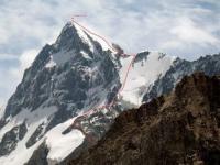
Dzhigit Peak.

Peaks in Karakol gorge in Terskey Ala-Too mountains.
“What is important is what you are doing here and now. It is important to climb the route with pleasure and it is not at all important to leave a mark for centuries. Who needs it, your footprint on this rocky wall that is not necessary for mankind?"
Yvon Showinard.
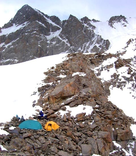
Climbing Dzhigit peak in Karakol gorge.
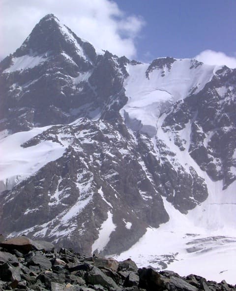
Dzhigit Peak with a height of 5170 meters above sea level is the second highest mark of the Terskey Ala-Too ridge, the peak is located in the main ridge, in the upper reaches of the Keltor River, in the Ak-Suu region in the east of the Issyk-Kul region.
On a topographic map in scale 1: 200,000, the height of the summit is indicated as 5020 meters above sea level. An almost sheer wall stretches along the crest of the ridge with a length of 3.5 kilometers from west to east in the eastern part, on which the Dzhigit peak is located.
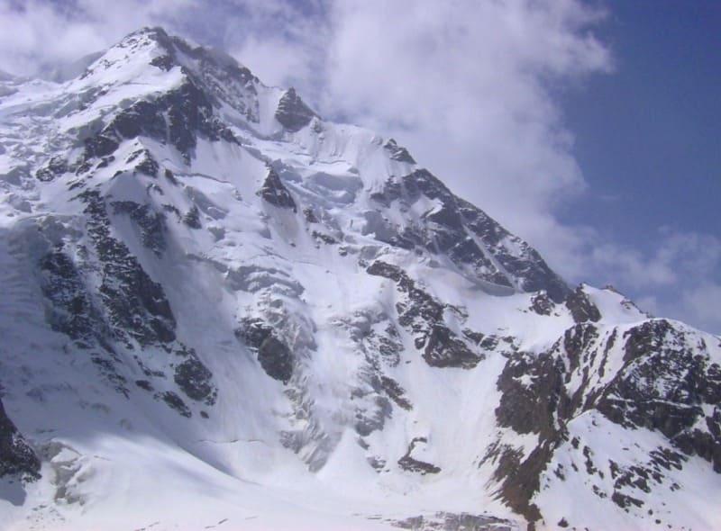
The northern wall of the summit reaches one and a half kilometers in height. A lot of difficult routes have been laid to the top, starting from 4A, through the Epyura pass and ending with 6B of category of difficulty, along the one and a half kilometer north face.
From the northern wall of the summit, the Keltor glacier descends with a length of 14 kilometers, bypassing the rocky cofferdam in the western part, in which the Ontor pass is located at a height of 3900 meters above sea level.
On the southern slope of Dzhigit peak there is a complex Karakoltor glacier with a length of 13 kilometers belonging to the Kuylyu river basin. As a rule, when climbing, climbers use rocky routes running along the northern wall of the summit.
The easiest routes are rated 4A, the most difficult 6B. These are truly routes of high courage, composure. The steepness of the slopes reaches from 45 to 75 degrees. The rocks of the summit are mainly monoliths, the cracks are filled with snow or ice.
For overnight ascent, it is necessary to prepare a place. Climbing routes are combined, where you have to use climbing, both on ice and on rocks. In 2.7 kilometers to the south-west of the Dzhigit peak there is the Elephant Peak with a height of 4726 meters above sea level. Karakolsky Peak is located 5.9 kilometers to the west and slightly to the south.
History of ascents to the Dzhigit peak.
Letavet continued the survey of the Kuylyu Ridge, begun in 1936. The expedition organized by him in 1937 included several experienced mountain climbers-athletes; the group had to climb the peaks discovered in 1936.
A participant in this ascent, the Kyrgyz climber Vladimir Ratsek subsequently, in 1939, led the ascent to another remarkable peak of this ridge - Dzhigit Peak along the eastern ridge of 5A category of difficulty. Together with him, this peak was won by Kemarsky and Berezin.
In 1958, four instructors-climbers of the Burevestnik DSO under the leadership of A.F. Kuznetsov made an ascent to the Karakol peak along the north-western ridge and for the first time made the traverse of the Karakol peak with a descent along the northeastern ridge before the ascent to Dzhigit.
1966 climbing along a simple route, along the western ridge was carried out under the guidance of S. Silchenko, difficulty category 4A.
1976 climbing the northern wall with a group led by D. Sharashanidze (first place in the USSR championship in the technical class), difficulty category 6A.
1983 climbing the northern face with a group led by V. Vakurin.
Climning to Mt. Djigit North face. Route up Albatros Peak (4720 m, 2B).
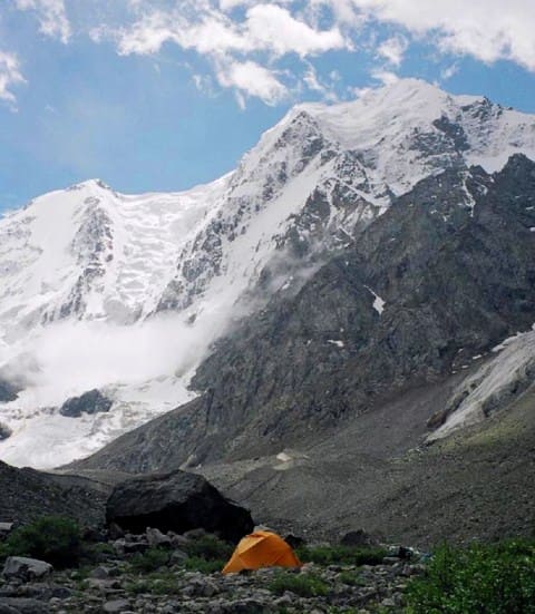
From the Karacol base camp, head southeast, in the wild and fascinating Kel-Tor valley. Here the first two and-a-half hour walk is through meadows brimming with edelweiss, then the tracks of the path disappear and you must proceed amongst large massive rocks two or three meters high.
In the second part of the course, the low-lying terrain of the upper part of the valley is often covered with water in the summer. In the end you reach the Dzhigit glacier; on the western side of the moraine there is a nice spot for bivouacking dominated by the impressive northern face of Mt. Dzhigit (4-6 hours).
From the bivouac, cross the glacier eastwards (I hour) and then head southeast, in the direction of Epiur pass (4,250 m), which is easily distinguishable among the Dzhigit group and Albatros peak (4,720 m). It is better to tackle the climb in the direction of the pass through the right-hand part of the slope, between Albatros peak and the little rock ridge.
Rope, crampons, ice axes and ice pitons are necessary. Normally the glacier is covered with snow. In the upper part there is a terminal crevasse that can be crossed over easily by keeping to the middle. It takes about three or four hours to reach the pass.
Then you go up along the southwestern ridge; for the first 300 meters you are on snow, and then you must climb up rock to the top (1 1/2-2 hours from the pass). The panorama is splendid. The descent follows the same route and takes about 3 hours.
The long eastern ridge of Mt. Dzhigit with its many cornices winds westwards from Epiur pass. This is a long and difficult route (3A) that takes more than a day to cover, so you must bring along all your bivouac equipment as well as ice axes, crampons, ice screws and rope.
Climbing to Western Ridge of Mt. Dzhigit (5170 m, 4A).
From the On-Tor glacier camp you can take a very pleasant route to the Kel-Tor valley. Head southeast towards On-Tor pass. You will need rope and ice axes. It takes about 2-3 hours to go up to the pass and another 1-2 hours to go down into the valley.
The route is dominated by the northern face of Mt. Dzhigit. From the On-Tor valley it looks like a pyramid, while from the Kel-Tor valley it appears as a very wide rock and ice massif. This is the side where the most difficult routes begin (6A), It takes three hours to get back to the camp.
The route on the western ridge of Dzhigit begins halfway between the camp and On-Tor pass. On the ridge that connects Dzhigit to Mt. Festivalnaya a snow ridge stands out clearly; this ridge descends to the On-Tor glacier, where the first part of the route runs.
For the most part this route goes over snow and ice, so that rope, ice axes and ice screws are necessary. In the first part you have two equally interesting alternatives. To get to the snow ridge you can go over a rocky section that is not too difficult (pitons, a hammer and a helmet are needed), or you can go to the left around the spur and climb up 100 meters of steep snow and ice (here you will need ice screws and perhaps an ice axe or two and an ice hammer).
The snow ridge is quite long, going over a mixed rock and ice terrain, up to the crest. You come out on a small plateau, where you can bivouac. Here you can leave all your gear and go up to the top with a light rucksack. Keep to the left of the wide crest.
For the last 100 - 200 meters the crest narrows, with large cornices on both sides, so you must be very careful. It takes about four or five hours to get to the top from the bivouac and another two hours to descend; these times may vary according to the condition of the snow and your acclimatization to the high altitude here. It takes another four or five hours to descend along the ridge from the bivouac to the valley.
Geographic coordinates of Dzhigit peak: N42 ° 11'26.53 "E78 ° 31'58.04"
Authority:
Alexander Petrov.
Zatulovsky D.M. "On the glaciers and peaks of Central Asia." OGIZ, State Publishing House of Geographical Literature. 1948.
http://mountains.tos.ru
Photos by
Sergei Pyshnenko, Bishkek city
http://karakol.kg