


![]()
You are here
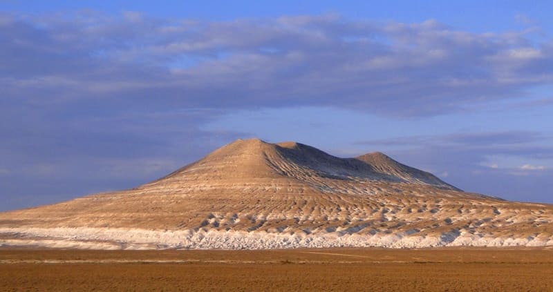
Desert lowlands of Mangyshlak.
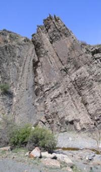
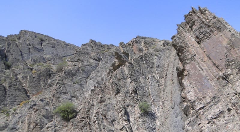
Beautiful Mangistau mountains.
“Across the plateau, and especially near the old caravan roads, wells are scattered. Their depth is significant. We had to see wells deeper than 40 meters (Kyzyl-Oik well in the north-eastern part of Ustyurt), wells 70 meters deep are known. Their device evokes a feeling of deep admiration for the diligence and skill of the builders. In a significant part of the shaft, the wells are fixed with rings cut from limestone, laid one on top of the other and connected with very strong cement. The diameters of the rings gradually decrease from bottom to top, so that the shaft as a whole is a huge truncated cone. A stone trough (astau), cut from a limestone block up to 2 meters long, is often installed near the well.
S. V. Viktorov. "Journey through Ustyurt".
Mountains of Mangyshlak.
Mangyshlak Peninsula is a massive ledge of the eastern shore of the Caspian Sea. The central part of Mangyshlak is a miniature upland formed by a single anticline fold; the southern flank of the anticline stretching from east to northwest is complicated by an additional fold.
The upland is located in the Tubkaragan and Mangistau districts of the Mangistau region. The upland consists of a very simple system of ridges: the Karatau ridge extends in the center, and the Aktau ridges - North and South - stretch along Karatau from the north and south.
The surface of the Karatau ridge has the form of a wavy plateau 3 - 9 kilometers wide with remnant peaks preserved in some places. The plateau is indented by numerous ravines-sai, which have steep, sometimes sheer slopes.
Otpan peak in Western Karatau reaches a height of 532.7 meters above sea level. It has the appearance of a mountain group with soft rounded contours. Both Western and Eastern Karatau have very steep slopes, almost vertical in places.
The slopes are heavily cut by deep ravines. Parallel to the southern slope of Karatau, the South Aktau stretches - a narrow ridge, abruptly breaking off to the west and north; it is cut through through ravines-sai. Northern Aktau stretches to the north of Karatau, like Southern Aktau, in some places it is interrupted by through ravines.
The surface of the ridge is plateau-like, the slopes are steep; the northern slope is more gentle, it is more indented than the southern one. The southern slope is very steep and dissected by small ravines, while the northern one is divided by deep ravines into a series of ridges.
On the slopes of Northern Aktau, bizarre forms of weathering are developed in the form of pillars, caves and niches. Karatau and Aktau are separated from each other by depressions - “valleys”. The northern valley has a very complex relief.
At its bottom, parallel to Karatau, there are several rows of low ridges with steep southern and gentle northern slopes 20-40 meters high. These are remnants, often having bizarre outlines. The relief of the southern valley is simpler, there are almost no ridges of remnants.
The western part of the Tyub-Karagan peninsula looks like a flat plateau 140 meters high above sea level. The northern, most flat part of the peninsula, which cuts off to the sea, is indented with sais, narrow and long (up to 10 kilometers).
The relief of the Mangyshlak Peninsula is in the closest connection with the geological structure and petrographic composition of the rocks. In the core of the Mangyshlak anticline, there are Triassic deposits collected in steep folds.
They form the central ridge - Karatau. The wings of the anticline are composed of Jurassic and Cretaceous rocks, with the Jurassic being represented by sandy-argillaceous rocks, and the Cretaceous by strong, dense limestones.
Cretaceous limestones were dissected on the wings of the anticline and formed the ridges - Southern and Northern Aktau, and easily destroyed sandy-argillaceous deposits of the Jura created negative relief forms - "valleys" - between the Aktau and Karatau ridges.
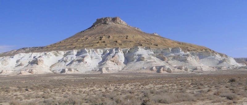
The flat Tyub-Karagan plateau is composed of tertiary rocks. Sarmatian limestones in the north of the peninsula are gently inclined towards the sea, in the south they are covered with Meotian limestones, which form the southern cliff of the peninsula.
On the Meotic limestones there are table heights of Pontic limestones. These remains are of great scientific interest, as they are composed of sediments of the Pontic Sea - one of the last seas that covered the southern territories of Kazakhstan.
Serozems with a very poorly expressed structure, often coarse, skeletal, are developed on Mangyshlak. Wormwoods predominate in the vegetation cover; saltwort. To the north of Mangyshlak there is a wide, low and flat expanse of the Buzachi Peninsula, composed of Caspian Quaternary sediments.
The surface of the peninsula is an elevated slightly undulating plain, gradually lowering to the north. In places there are dunes and hilly sands. In the northern part of the Buzachi peninsula, large areas are occupied by saline land.
A discontinuous chain of solonchaks separates the Buzachi Peninsula from the Mangyshlak Peninsula in the south. There are many wells with good water in the sands.
Geographic coordinates of Mangyshlak Peninsula: N44°12'17.70" E51°26'42.07"
Authority:
Gvozdetsky N.A., Golubchikov Yu.N. "Mountains", series "Nature of the World". Moscow, Thought, 1987.
Alexander Petrov.
http://big-archive.ru
Photos by
Alexander Petrov.