


![]()
You are here
Climate in Ala-Archa park.

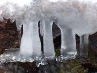
Photo tours in Ala-Archa gorge.
"Starry blizzard in the sky -
This is for good weather
Hello Tien Shan spruce,
Hello, our roads."
A. Shumeiko.
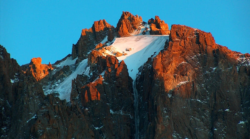
Photos of Ala-Archa gorge.
The climate of the Ala-Archi basin is influenced by atmospheric circulation processes developing over the spaces of Western Siberia and Kazakhstan, the impact of high-altitude zoning and significant solar radiation.
The mountain systems of Central Asia, in turn, also have a significant impact on its climatic features. Powerful fronts and cyclones form over the mountains, precipitation intensifies, mountains increase the impact of radiation factors and soften the continental climate inherent in the nearby plains.
The conditions of atmospheric circulation over the Ala-Archi basin are determined mainly by the fact that the air masses here are replaced mainly due to the influx of continental air masses from Sibiri and Kazakhstan.
Atlantic air with its typical properties hardly penetrates here. In winter, cold northeastern winds prevail here, carrying continental Siberian air. In summer, northern and northwestern winds dominate, which bring continental air to Western Siberia and the southeastern regions of the European part of Russia.
In the south, over Central Asia, much warmer air masses are formed, which in summer have a tropical character. Although they very rarely penetrate this basin, their interaction with the northern masses can form fronts and sediments.
In winter and spring, atmospheric fronts are often aggravated over the Pamir-Alai, and cyclonic waves and cyclones with rains and snowfalls are formed, relatively weak echoes of which reach the western Tien Shan. In summer, over the Tien-Shan, approximately from the Talass region and to the east, the Asian branch of the polar front is formed, on which cyclones are formed relatively often with frequent, although rather weak, precipitation in the Ala-Archi region.
This branch ends around September. In addition to these general circulation processes of the atmosphere, the Ala-Archi basin is also characterized by local winds - hair dryers and mountain breezes. A warm and dry hair dryer occurs at high air pressure on the Susamyr plateau, which lies to the south of the ridge.
This air rises along the southern slope of the Kyrgyz ridge and passes to its northern slope. According to the laws of hair dryer formation, the air brings warmth and dryness to the Ala-Archi basin. Mountain breezes determine the daily wind direction in the Ala-Archi gorge: during the day it is north, and at night it is south.
These breezes are influenced by the daytime heating of the Chui Valley and the formation of increased pressure there at a level of 2 - 3 kilometers above sea level. For a more specific characterization of the climate of the Ala-Archa basin by the seasons, let us take the average observation data of the Alplager Ala-Archa weather station located at an altitude of 2100 meters above sea level.
Spring in the Ala-Archa gorge is quite energetic. This is especially noticeable on the slopes of the southern exposure. In the high-mountainous part of the region, where a lot of heat is spent on melting snow, the rise in temperatures slows down, heat comes later.
The transition of the average air temperature through 0 ° occurs in the alpine camp in the second half of March. Average temperatures in April are already always positive here. In April they are usually around +3 degrees, and in May around + 5 °.
The spring months are accompanied by tu-mans, snowfalls and rains. The amount of precipitation in spring increases significantly compared to winter months and averages about 80 mm per month. Snow cover in the form of spots is kept in the area of the alpine camp until the end of May.
Summers in the camp area are humid and cool. The average temperature of the summer months is + 12.0 °. For comparison, let us point out that the average temperature in Moscow at this time is 1 - 19 °. The warmest month is August, and in the highlands, September is almost as warm as August.
The maximum summer temperatures reach 27 - 30 °, and the minimum - 0.2 and - 0.3 °. The frequency and amount of precipitation increases in comparison with spring: the summer months have 17 - 22 days with precipitation.
In July, the maximum precipitation, which consists of precipitation from cold fronts and precipitation, falling as a result of local air circulation. Autumn in the Ala-Archi basin is clear and warm, especially in September. In October, the average and minimum temperatures drop sharply.
At this time, there is a transition of average daily temperatures through 0 °. Snow falls around this time. There is almost no rain in September. This is the warmest and clearest month of autumn. The maximum September temperatures sometimes reach + 25 °, and the minimum - 2.5 °.
Average October temperatures here are about + 3.0 °, with a maximum of + 18.0 ° and a minimum of 16.0 °. November is cold and in terms of temperature it is the winter month. In autumn, only about 50 mm of precipitation falls in three months. Most of them are in November.
Winter in the Ala-Archa gorge is rather cold, but not harsh. The valleys of the region are protected by ridges from the northeastern winds prevailing in Kazakhstan in winter. At the same time, the valleys are sufficiently well ventilated, and therefore the air in them is not retained and is not subjected to prolonged cooling.
In the highlands, winters are colder, which is explained not only by a decrease in temperature with altitude, but also by the fact that these places are open to cold winds. The average January temperature at an altitude of 2,100 meters above sea level is 7.5 ° (in Moscow - 10.8 °).
The lowest temperatures are observed in February. During the winter, the Ala-Archi area is often exposed to the influence of warm hair dryers that cause thaws. There are times when air temperatures in winter rise to 0 ° and higher.
There is relatively little precipitation during the winter, about 80 mm. This precipitation in the form of snow falls when approaching southern cyclones. In general, the Ala-Archi basin in terms of temperature is close to the mountainous regions of the Central Caucasus.
The amount of precipitation in the Ala-Archi region is relatively low (520 - 760 mm per year). In summer, their number gradually increases with height above sea level, and in winter (from November to February), on the contrary, the higher in the mountains, the less precipitation.
There are more of them in spring than in autumn and winter. The driest month for all belts is September. Summer in the mountains is humid. In July, precipitation in the highlands is seven to eight times more than in the mid-high mountains.
The predominance of north-westerly winds in summer, and north-east winds in winter leads to an uneven distribution of precipitation in the area, depending on the exposure of the slopes. The snow cover is generally small and reaches a maximum thickness of 60 - 70 cm in the valley.
The deepest snow is observed in the middle-high mountains in March, in the foothills in February, and in the highlands the most snow is in April. The maximum snow cover for the entire Ala-Archi region occurs in medium-high mountains (sometimes more than 70 cm).
It lingers and remains here due to the protective properties of the forest. In the highlands, the blowing of snow is very high, due to which, throughout the winter, bare areas of stones alternate with depressions covered with snow.
On the sidelines, at the bottom of gorges and canyons, so much snow accumulates that it lies here until June, and sharp ridges of rocks and steep rocky slopes remain snowless throughout the winter. It should be borne in mind that the southern slopes can be cleared of snow during the first winter sunny days, the northern slopes remain under a thick layer of snow until spring, and in the highlands until summer.
Authority:
Kuznetsov "Alaarcha". “Defeated peaks. 1973 - 1974 ". “Mysl”. Publishing House, 1976.
Photos by
Alexander Petrov.