


![]()
You are here
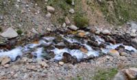
Chunkurchak river.
Hiking in Chunkurchak gorge.
"There is no big fish in clean water."
Chinese proverb.
Sights of Chunkurchak gorge.
The Chunkurchak River is a left tributary of the Alamedin River, located on the eastern slope of the Alamedin gorge, on the northern slope of the Kyrgyz Ala-Too in the Alamudun district of the Chui oblast. After 34.2 kilometers from the source, the Alamedin receives a tributary of the Chunkurchak on the left, with a length of 18.2 kilometers, which originates at an altitude of 3680 meters above sea level.
The sources of the river begin from the northern tongues of the West Baichechekei and East Baichechey glaciers. Also, in the northern ridge of the upper, western part of the Chunkurchak gorge, there are three small unnamed glaciers, from which the river receives left tributaries.
The glacier moraine, which starts from the northern tongue of the Beychechey West glacier, is 3 kilometers long. There are 5 small moraine lakes on the moraine. The main channel of the river is formed at an altitude of 2,451 meters above sea level.
5.7 kilometers after the source, an unnamed stream flows into Chunkurchak on the right. At 9.6 kilometers, the river enters a narrow and deep gorge of the same name, 3.7 kilometers long. The river reaches the Tatyr village 14.5 kilometers after its source.
The mouth of the river is located at an altitude of 1310 meters above sea level. The Chunkurchak River is the longest tributary of the Alamedin River.
Geographic coordinates of the Chunkurchak River: N42 ° 38'38.47 "E74 ° 36'58.83"
Authority and photos by
Alexander Petrov.