


![]()
You are here
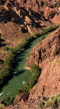
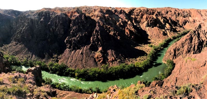
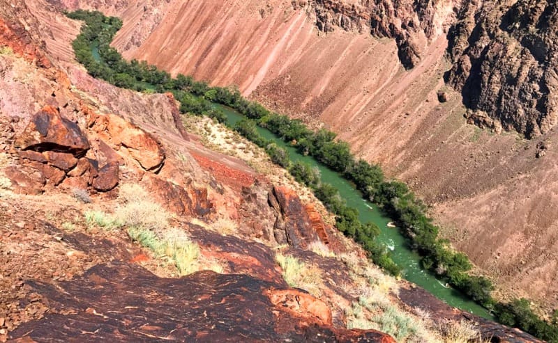
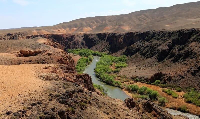
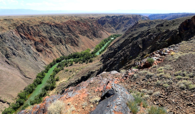
Canyon of Charyn River.
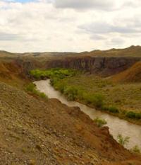
Journey along canyon of Charyn River.
“Ask nature, she keeps all the truths and will answer your questions without fail and satisfactorily”
R. Bacon.
Best trip to Charyn canyon.
The main canyon on the Charyn River is located at an altitude of 1411.6 and up to 764.4 meters above sea level, starts at the confluence of the Shet-Merke and Kegen rivers and ends in the Taskara valley 5.6 kilometers before the automobile bridge over the Charyn River on the Chilik highway - Chundzha, partially located on the territory of the Charyn Natural Park, in the Uigur, Rayymbek and Enbekshikazakh districts of the Almaty region.
The canyon stretches from southwest to northeast for 73 kilometers. The birth of the Charyn River is given by the flow into the Kegen River of its left tributary Shet-Merke with a length of 33 kilometers. The Shet-Merke River originates on the northern slope of the Kungei Alatau ridge.
The sources of the river begin from two moraine lakes: Shet-Merke located in the upper reaches of the river at an altitude of 3254 meters above sea level and the lake of the eastern tributary of the river, located at an altitude of 3346 meters above sea level.
The length of the Kegen River is 122 kilometers. The river begins its journey in a wide valley between the southern slopes of the Ketmen ridge and the northern slopes of the Elshyn-Buiryk mountains, flows southwest, passing the northern slopes of the Sholadyr mountains.
Then it turns to the north-west and, bypassing the southern slopes of the Temirlik mountains, approaches the village of Kegen along a wide valley. In front of the southern slopes of the Kuluk-Tau mountains, in the vicinity of the village of Zhalauly, the river heads west along a wide valley opposite the southern slopes of the Bestobe mountains.
In the vicinity of the Koltykbastau ravine, Kegen enters the canyon and gradually, the waters of the river reach the Bestyubinsk reservoir with a length of 4.5 kilometers. Bypassing the reservoir, the Kegen River passes a 9-kilometer underground diversion channel and in the southern part of the Kalasai valley, at the mouth of the Shet-Merke River at an altitude of 1411.6 meters above sea level, and loses its name.
The beginning of the first cascade of the Charyn canyon with a length of 5 kilometers begins at an altitude of 1411.6 meters above sea level, 1.7 kilometers southwest of Mount Moinak with a height of 1878.5 meters above sea level.
At an altitude of 1237 meters above sea level, the valley of the Charyn River expands and in some places reaches 1100 meters of the floodplain bottom of the valley. On the left bank of the valley there is the Aktogay valley, on the opposite side - the Zhalasai valley.
Thus, the floodplain, wide valley stretches for 19 kilometers. For 3.5 kilometers from the beginning, on the right bank of the river, there are hydraulic structures and open switchgears of the Moinak hydroelectric power station.
2.8 kilometers after the end of the First cascade of the canyon in the bed of the Charyn river, there is an anti-mudflow dam, 570 meters long, which blocks the river bed. From the west, the Zhalanash valley adjoins the Charyn River, which stretches from the village of Togyzbulak and ends in the Kopaly tract for 24 kilometers.
At an altitude of 1152 meters above sea level, in the vicinity of the Aktogay farm, the Second Cascade of the Charyn Canyon begins, 49 kilometers long. This section of the canyon is interesting for sports rafting, it starts from the Albatross canyon, which stretches for a little over 8 kilometers.
In the Albatross Canyon there are several difficult rapids of a high difficulty category for passing, which require the highest skill of athletes. For 2.4 kilometers in front of the Kegen bridge across the Charyn river, the Uzynsai log adjoins on the right.
The Albatross Canyon ends at the height of the riverbed at 1072.3 meters above sea level. Behind the bridge, on the elevation of the left bank of the river, there is a picturesque tract Kurtogay. After about 1 kilometer, down the river, there is the First Cascade of Rapids "Toothbrush" with elements of the 5th and 6th category of difficulty.
The first cascade of rapids consists of two sections of difficult rapids: the first is 130 meters long, then follows 200 meters of calm water and soon begins the second section of white water 160 meters long. Literally, 400 meters after the First cascade of rapids, the Second cascade of rapids "Toothbrush" begins with identical elements of difficulty on the previous one.
The length of the Second Cascade of Rapids is 350 meters. At the end of the Second Cascade of Rapids, at an altitude of the river bed of 1022.5 meters above sea level, the dry bed of the Charyn Lunar Canyon, 3 kilometers long, adjoins the right bank of the river.
After the end of the Moon Canyon, the Kathu Mountains begin along the right bank with a dominant mark 1257.7 meters above sea level. On the left bank, from west to east, the Toraigyr mountains stretch with a dominant mark in the western part - Mount Japalak, 2413.6 meters high above sea level.
In the north-eastern tip of the Toraigyr mountains is the Valley of Castles. The Valley of Castles is located at an altitude of 1112 to 910.9 meters above sea level, on the left bank of the Charyn River, on the territory of the Charyn Natural Park, in the Uygur district of the Almaty region.
The quaint Valley of Castles stretches from northwest to southeast for 2550 meters. The area of the Valley of Castles is 653260 square meters, the perimeter of the valley is 3934.65 meters. After 3.4 kilometers after the Valley of Castles on the right, the dry bed of the Bestamak canyon adjoins the shore.
Bestamak Canyon or the Small Canyon of the Charyn River is located at an altitude of 943 meters above sea level, in a dry channel of a seasonal stream, on the territory of the Charyn Natural Park, on the border of the Uigur and Enbekshikazakh regions of the Almaty region.
The mark with a height of 943 meters above sea level is located 300 meters from the right bank of the Charyn River in the Bestamak canyon. The length of the canyon is 8 kilometers. The beginning of the canyon is located 10.5 kilometers north and a little west of the village of Aksai and 1.2 kilometers north of Mount Bestamak, 1166 meters above sea level.
For 4.7 kilometers to the right tributary of the Temerlik River at an altitude of 865.8 meters above sea level, the Charyn River flows in a narrow, steep-sided canyon. The Temirlik River has cut its course to the granite horizon of the parent rock and flows into the Charyn in a noisy stream.
The sources of Temirlik are located in the Ketmen ridge and the Temirlik mountains. The river is formed from the confluence: the eastern tributary of the Zhanakarasai and the western Komirshi Severny. The sources of the Temirlik River are located at an altitude of 2819.8 meters above sea level in the western part of the main Ketmen ridge.
The length of the Temirlik River is 58 kilometers, the area is 523 square kilometers. The river belongs to the Ili basin. 7 kilometers after the mouth of Temirlik, downstream begins the Saigak rapid of the 5th category of complexity, the length of the main part of the rapid is 400 meters.
The remaining 300 meters of the rapids belong to the 3rd category of difficulty. After 700 meters on the river, the next obstacle for lovers of sports rafting is the Bronenosets threshold of the 6th category of difficulty.
The length of the main, difficult part of the threshold is 350 meters, the remaining part of 680 meters is not difficult. The remaining 6 kilometers before the end of the canyon, the river flows in a narrow channel with steep and steep slopes. Before flowing into the Ili River, Charyn flows for another 82 kilometers.
Geographical coordinates of canyon of Charyn River: N43°18'13.19" E79°00'40.45"
Authority and photos by:
Alexander Petrov.