


![]()
You are here
Atyrau region.

Tours to Atyrau region.
“Only a kind and talented people can maintain a stately serenity of spirit and humor in any, and the most difficult, circumstances. Proverbs, sayings, jokes, being born in the depths of the masses, speak of a healthy, powerful organism."
Vladimir Ivanovich Dal.
Tours to the western regions of Kazakhstan.
The territory of the Atyrau region is 118.6 thousand square kilometers. The population of the region as of January 1, 2007 amounted to 480.7 thousand people. Average population density in the region per 1 sq. km. territory is 4.1 people.
Atyrau region is located mainly within the vast Caspian lowland. The relief of the territory is an undulating plain, imperceptibly rising from the coast of the Caspian Sea. A significant part of the Caspian lowland is occupied by ridge and dune sands (Naryn, Taisoigan, Karakum).
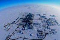
In the north-east of the region, an insignificant part is occupied by the spurs of the Subural Cretaceous plateau. There are rich deposits of oil and gas (Ural-Emba oil-bearing region), potassium and sodium salts, borate and others.
The climate is sharply continental and dry. Summers are dry, long and hot; winter with little snow, cold. The average temperature in January is 8 - 11 C, in July +24 + 25 C. The annual precipitation is 100 - 200 mm.
The major rivers flowing through the territory of the region are the Ural (total length 2428 km, within Kazakhstan 1082 km), Zhem (712 km), Sagyz (511 km), Oyil (800 km). The largest lake in the region is Inder (110.5 sq. Km).
Mainly semi-desert brown soils with semi-desert vegetation prevail. Half of the region's territory is occupied by solonetz and saline complexes, as well as sands. Poplar and willow groves are found along the river banks.
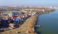
The center of the region is located in the city of Atyrau (until 1992 - Guryev), which is located on the Ural River and was founded in 1640. As of January 1, 2007, 207.2 thousand people lived in the city, or 43.1% of the total population of the region.
The distance from Atyrau to Astana is 1,810 km. There are 2 cities, 7 districts, 2 villages, 191 rural settlements in the region, the urban population is 274.6 thousand people (57.1%), rural 206.1 thousand people (42.9%).
The ethnic composition of the region as of January 1, 2007 was: Kazakhs - 90.9%, Russians - 6.9%, Tatars - 0.5%, Ukrainians - 0.3%, Germans - 0.1%, Belarusians - 0.1 %, others - 1.3%. In Atyrau, every stone breathes with antiquity.
More than a thousand monuments of history, archeology, architecture and monumental art (of which 54 are historical, 119 are monumental art, 43 are archaeological, 150 are architectural and more than 800 religious buildings) remind descendants of the greatness of the spiritual heritage of their ancestors.
Atyrau land was mastered by man about 10 thousand years ago, at the dawn of the Neolithic - the new Stone Age. At the sites of ancient settlements, many stone products, pottery, arrowheads have been preserved.
At the end of the 4th - beginning of the 3rd millennium BC. there is a sharp change in the economic and economic activities of the ancient tribes. For the first time, herds of domestic animals appear on the territory of the Northern Caspian region.
From that time to the present day, cattle breeding has become the main occupation of the population of Mesopotamia. The campsites of the most ancient pastoralists were found in the Dengiz (now Kurmangazy) region not far from the Konyr Kuduk well, the Kok Murun dune, near the village of New Ushtagan and the Kadyr Gali dune, near the Sazda winter quarters.
Judging by the area of their campsites, the ancient pastoralists used small-sized ground dwellings. It is quite possible that these were light structures like a traditional Kazakh yurt. The further development of the Caspian cattle-breeding tribes took place in the 3rd - 2nd millennium BC. during the Bronze Age and Early Iron Age.
At this time, pastoralists completely occupy the entire steppe zone. Copper and bronze metallurgy was born and flourished; stone tools were replaced by metal products. 19 monuments of the Bronze Age and 128 of the Early Iron Age were found on the territory of the region.
A large number of them are concentrated in the Emba region and near the village of Karaton, Sarykamys, near the Imankara mountain, the Araltobe mound. With the development of cattle breeding, the cultural and economic contacts of the population of the steppes sharply increased.
In the Bronze Age, significant ethnocultural shifts took place in the steppe zone, large tribal associations, unified in culture, were formed, under whose control huge steppe regions were. During this period, the basis of the ethnogenesis of many future historically famous peoples was formed.
The earliest written sources report fragmentary information about those who lived on the banks Almost two and a half thousand years ago, the warlike and powerful Sarmatian tribes, akin to the Scythians of the Black Sea region.
Hundreds of various archaeological sites have been discovered here: ancient settlements and sites, fortresses and workshops. In the mounds and burials of the Sarmatian tribes of the IVth - IIIrd centuries BC. weapons, pottery, bronze mirrors, numerous beads of semi-precious stones and glass are well preserved.
A lot of interesting finds were discovered near the village of Ganyushkino, near Lake Ata-Kul. Written sources of the XIII - XVI centuries contain valuable information about the economic structure and life of Kazakh nomads.
For example, in the book of Fazallah bin Ruzbeikhan "Mikhman-namei-Bukhara" it is reported that the Kazakh ulus had winter quarters and summer quarters, which were located at a distance of several hundred forsags.
Wintering was on the banks of the Seikhun (Syrdarya) River and in the Karakum Desert, and summer pastures were on the outskirts of Desht-i-Kypchak up to the Itil River (Volga).
Authority:
Guide to the Atyrau region. Published by the Regional Department of Tourism, 2018.