


![]()
You are here
Aral asar ancient settlement.
Ancient sites of ancient settlement East Aral sea.
"In reality, history does not belong to us, but we belong to history."
Hans Georg Gadamer.
Tours to Aral Sea.
Aral asar settlement is located at an altitude of 35 meters above sea level, 4.5 kilometers southeast of Kerderi mausoleum, 64.7 kilometers southwest of Karateren settlement, 123 kilometers northwest of Kaukei settlement, 92.4 kilometers west of Zhanatalap settlement in Aral district of Kyzylorda region.
"Another striking archeological discovery was associated with the "Aral catastrophe", the reduction of its borders and the retreat of the coastline. In 2001, a mausoleum made of stone and burnt brick was discovered on the dried-up seabed. The construction of the mausoleum was attributed to the XIVth century.
And again attention to the archaeological monuments at the bottom of the Aral was attracted by the discovery of a medieval settlement and necropolis here in 2004. The Aral is a unique basin, called a sea despite the fact that it is surrounded on all sides by deserts and has no connection with the ocean.
Like most closed basins of the arid zone, the Aral has a very unstable level. Naturally, the area, volume of the sea and its mineralization change along with the level. However, the main factor on which the very existence of such a vast basin depends, as well as changes in its level not by units, but by tens of meters, is the volume of runoff and the duration of the flow of the largest rivers of Central Asia - the Amu Darya and Syr Darya - into the Aral.
This position is easily proven by the fact that at the time when these rivers, migrating along the plains of Central Asia, did not reach the Aral Depression, it was dry, and eolian processes dominated in it. The long turn of the Amu Darya to Sarykamysh occurred in connection with the capture of Khorezm by Timur, whose troops almost completely destroyed many cities and irrigation systems.
As a result, the Amu Darya rushed into the Sarykamysh depression, filled it and, possibly, briefly flowed along the Uzboy. The level of the Aral dropped to 43 - 44 meters. This happened at the end of the XIVth century. But already in the XVth century, the level of Lake Sarykamysh dropped to 10 meters, then rose again to 30 meters and remained at this or very close level for quite a long time.
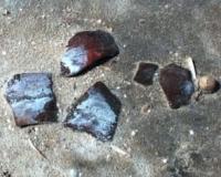
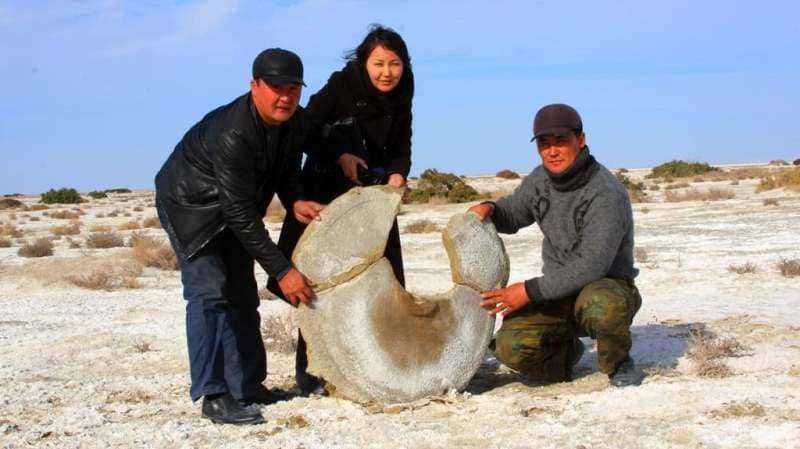
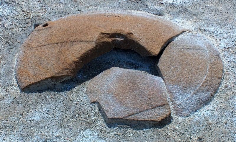
The total area of the Aral asar settlement is about 6 hectares. A large number of household items were found on the surface: millstones, ceramic vessels and their fragments, fragments of iron and bronze products, silver coins, mid-XIVth century. "
Authority:
http://www.madenimura.kz/ru/culture-legacy/region/kyzylorda_oblast/excavation/aral
"The Aral-Asar settlement is located 143.7 kilometers west of the Aiteke-bi village (Kazalinsk) and 64.8 kilometers southwest of the Karateren village in the Aral district of the Kyzylorda region. The Kazakhstani part of the Aral Sea region today presents a bleak picture: a clay plain dried up by the sun is cut by the river beds of the ancient Syrdarya delta.
The terrain from a bird's eye view resembles a giant triangle. Its area is over 400 square kilometers. From the north and north-east, the plain is limited by the modern bed of the Syr Darya, from the west by the Aral Sea (or rather, by what remains of it), and from the south by the sands of the Kyzyl Kum desert.
This was not always the case - the appearance of this territory changed several times: either there was a wasteland, or the sea waves rustled. At different times, people of completely different cultures flocked here. It is no coincidence that the famous researcher of the history and culture of Central Asia, Sergei Tolstov, gave this land the name "Aral Knot of Ethnogenesis".
And the proof of the former stormy life is the whole cities that local archaeologists find on the former seabed. In 2004, a medieval settlement and a necropolis were found. The settlement, conventionally named Aral-Asar, is located 64,8 kilometers north of the village of Karateren and 370 kilometers away from Kyzylorda.
The village of Karateren, not so long ago, stood on the shores of the Aral Sea, now it is 120 kilometers away from it. The total area of the settlement is about 6 hectares. A large number of household items and millstones, ceramic vessels and their fragments, fragments of iron and bronze items were found on the surface.
Building structures are poorly visible on the surface. They are washed out and smoothed by the waters of the Aral Sea. An irrigation canal 2 - 2.5 meters wide, passing through the settlement, testifies to a developed irrigation system and the fact that residents have drawn water here, apparently from the channels of the ancient channels of the Amu Darya or Syrdarya for many tens of kilometers.
Residents of cities and suburbs were engaged in agriculture, growing grain. Found 14 millstones and adjacent premises for storing flour - humdans. Milling production was developed. The collected glazed ceramics of turquoise, dark blue color testifies to the life of the settlement at the end of the XIII - XIV centuries, perhaps at the beginning of the XV century.
At a depth of 30 centimeters, a surface lined with burnt brick fragments was discovered. In the center of this masonry there is a large vessel - hum, more than three-quarters buried in the ground, and the upper part was lined with burnt brick so that the shoulders of the vessel were hidden.
Apparently, the settlement is "one-layer" and existed for a short time, perhaps one century. Unexpected for researchers, the finds of cities on the bottom of the Aral Sea give rise to a discussion about the ecological crisis in the Aral Sea basin, which is now being observed.
What caused crises now and in the past? What are the objective patterns of interaction between society and the natural environment in the Aral Sea region? Despite the fact that its main buildings were greatly eroded, archaeologists nevertheless restored the appearance of an unknown settlement almost bit by bit.
First of all, we determined its area - six hectares. After that it was necessary to establish the age. The ceramics found during the excavations helped to do this - they belonged to the end of the XIV century, that is, the period of the Golden Horde. Scientists do not exclude: Aral asar was a powerful production zone for the supply of flour for export.
But this is strange. The population of the Central Asian region in those distant times mainly led a nomadic lifestyle and was engaged in cattle breeding. And therefore, the objects of agricultural industry became a real surprise for scientists. How the whole city grew up in this place is anyone's guess.
Aral-Asar is located far from ancient large settlements. The closest of them - Kesken-Kuyuk-Kale and Jend - are 200 kilometers away. Presumably, some of the people from there came to live in Aral asar, however, there is another version.
Residents could have moved here from cities that are still hidden by the waters of the Aral Sea and are still unknown to us. It is not known for certain who the inhabitants of the settlement were. There is an assumption that these were ethnic descendants of mixed Oguz-Kipchak tribes.
Oguzes are considered the ancestors of modern Turkmens, Azerbaijanis and Turks. And the Kipchaks were the forefathers of the Tatars, Kazakhs, Bashkirs, Karachais and other peoples. As the ancient written sources say, at that time the Oghuz tribes were gradually ousted from these areas by the Kipchak clan nobility.
But not all left the inhabited territories. It is possible that one of the tribes remained to live in Aral asar. It was built thoroughly, as if for centuries. On one side, an industrial zone was located in a crescent. The residential sector was in the center.
Rice fields with irrigation systems were separated from residential buildings by powerful artificial canals with a width of at least three meters. Unfortunately, the unique structures were blurred, as a result of which only fragments of houses were found.
Most of them were adobe buildings with a standard layout for that time. In the center is a tandoor (a universal stove used both for cooking and for heating), which was built into a sufu - a stove bench that occupied most of the room.
Its sides were made of mud bricks, and the space between the wall was filled with soil.
The very existence of such a vast basin directly depends on the volume of the large rivers of Central Asia flowing into it - the Amu Darya and the Syr Darya. At the beginning of the Ist millennium BC, the Amu Darya completely filled the Aral basin, and since the Syr Darya also flowed into it at the same time, the sea reached its maximum level.
However, in subsequent historical periods, the Amu Darya turned its waters to the west several times, to the Sarykamysh depression, draining the Aral. So it was in the middle of the first millennium of our era - in the IV - VI centuries, when the sea level dropped significantly.
From VII to XIII centuries. the direction of the flow of the Amu Darya was restored, and the Aral was again filled. However, during the Mongol invasion at the beginning of the XIIIth century, which, as researchers suggest, led to the destruction of irrigation systems in the lower reaches of the river, the Amu Darya again turned its waters.
The next time the turn of its course, apparently, took place after the capture of Khorezm by Timur, whose troops completely destroyed the system of canals and drainage systems. As a result, the Aral Sea again left its shores.
And it happened just at the end of the fourteenth century.
Apparently, it was then that Aral-Asar arose. On the day that was revealed, they began to build houses, the city gradually grew and developed. But unstable waters filled the cavity again, burying everything built by people. Most likely, the water arrived quickly, and the residents barely had enough time to collect the necessary belongings and leave their homes.
Without a doubt, they did not expect the sea to return so soon. A fly-over of the territory and aerial photography made at the beginning of the year showed that former plantations of fields with developed irrigation systems stretch for kilometers on the seabed. If so, there must have been whole settlements nearby.
Geographic coordinates of Aral-Asar settlement: N45°42'33 E60°18'58


Authority:
Stepan Krivosheev, "Itogi", № 21/623 from 20.05.200
Photos by:
Alexander Petrov.