


![]()
You are here
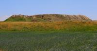
Ancient sttlement Ozgent.
Ancient settlements of Kyzylorda region.
“... the ruins of the mountains. Uzgenta (Kyrgy-Uzgent, i.e., distant Uzgent) are located near the dry bed of the Oguz-Dzhilgay river, ditches were drawn from it, which are well preserved. Judging by the traces of former buildings scattered on all sides, it was a large city with a fortress inside...".
Joseph Antonovich Castagne. "Antiquities of the Kirghiz steppe and the Orenburg region". 1910.
Archaeological expeditions in Kyzylorda region.
Ozgent settlement dates back to the VIIIth - XVIIth centuries AD, located at an altitude of 168 meters above sea level, located 550 meters southwest of the ruins of Kyruzgent, on the eastern edge of the Kyzylkum sands, 15.8 kilometers west of the left bank of the Syrdarya River, 10.5 kilometers southwest of the village named after Mashbek Nalibaev (Akzhol), 8 kilometers southwest of the village of Abdigappar, 3.1 kilometers southeast of the Tolegatay-baba complex, in the Zhanakorgan district of the Kyzylorda region.
The first studies of the settlement of Ozgent were carried out by Vasily Andreevich Kallaur. Iosif Antonovich Kastanye gives his description of the settlement in the book “Antiquities of the Kirghiz steppe and the Orenburg region” (1910): “... the ruins of the mountains. Uzgenta (Kyrgy-Uzgent, i.e. distant Uzgent); (writing today - Ozgent) are located near the dry bed of the Oguz-Dzhilgay river, ditches were drawn from it, which are well preserved. Judging by the traces of former buildings scattered on all sides, it was a large city with a fortress inside...".
In 1963 - 1966, small studies were carried out by the Khorezm archaeological and ethnographic expedition. Her employees found several copper coins here. Archaeological research has not been carried out on the settlement. In 2018, a survey of the settlement of Ozgent was carried out.
Ozgent settlement is located on a flat area. On the north side of the settlement there is a floodplain of the old Syrdarya channel, overgrown with shrubs, trees and grass. The settlement occupies an area of a hill measuring 607 x 571 meters, elongated from north to south.
The area of the settlement is 405,376 square meters. The height of the hill is 3 meters. The settlement was fortified with a powerful fortification system - two rows of walls with towers and a moat. In some places, the remains of 15 watchtowers are visible.
The settlement is surrounded by a moat 2 meters deep and 10 meters wide. The entrance gate is located in the eastern part of the settlement.
Geographical coordinates of Ozgent settlement: N43°44'03.01" E67°04'54.45"
Authority
https://www.archeology.kz/ru/1758-gorodishhe_ozgent_kompleks_tolegetaj_baba.html
Alexander Petrov.
Photos by
Alexander Petrov.