


![]()
You are here
Ancient settlement Martyk-kala.
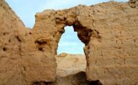
Photo tours in Kazakhstan.
“History repeats itself. This is one of her shortcomings"
K. Darrow.
The best sights of ancient architecture in Kazakhstan.
The Martyk-kala settlement is located in the Zhalagash district of the Kyzylorda region, 44.5 kilometers southwest of the Zhanadarya village and 34.5 kilometers southeast of the Akkyr village. The ruins of the ancient settlement Martyk-kala are located 1.7 kilometers northeast of the Eastern Kum-kala (Kum-kala II).
The settlements on the settlement consist of small, compactly located manor houses, among which the house stands out for its size (18 x 18 meters) and good preservation, which apparently belonged to the owner of this village.
The layout of the houses is very curious: it has nine rooms, including a central square “hall” with four narrow corridors-corridors in the corners leading to the “vestibules” and overlooking the north and south facades of the building; they may have been open (along type of aivans).
The masonry of the walls of this house is similar to the masonry of the walls of Eastern Kumkala. Pottery is also similar to the East Kumkala and synchronous with it. It refers mainly to the XII - XIV centuries. So, according to our data, the history of the functioning of the channel of the Inkardarya and Zhanadarya, the development of the adjacent lands by man is drawn schematically as follows: the center of settlement of the southern group of Oguzes, apparently, who came in the IXth - XIth centuries. from the north to Inkardarya, due to its flooding during this period, there was an area of the eastern part of the channel; in the western parts of it, already known, the dominant place is occupied by monuments of primitiveness and ancient times, although there are traces of the activity of the Middle Ages.
To the east, where the branching of the Inkardarya channel into the northern and southern sections is observed, medieval archaeological sites are already becoming dominant. There are many medieval canals here, and irrigation retains a primitive character, typical of unsustainable agriculture in semi-settled delta regions; there are very deep ancient canals, systems of reservoirs-basins, dams made of branches and clay; along the banks of the Inkardarya, on its northern section, many ruins of peasant estates were discovered, preserved in the form of square or circular layouts.
An example is a square layout with an area of 60 x 60 meters, the walls of which have been preserved in the form of ramparts about 2 meters wide. The northern wall is directly adjacent to the channel, and the ends of the outer fence, which has the shape of an irregular circle, framing the square layout on three sides, rests on it.
Inside the square layout, residential premises apparently adjoined its walls - on the ramparts there are many fragments of Middle Ages ceramics, stucco and handicraft, and fragments of furnaces; on other similar layouts, ruins of residential premises were found, located along the perimeter of the walls.
The outer courtyard adjacent to the square-plan residential complex apparently served as a herd for cattle. Not far from such fortified country-type estates, as a rule, there are canals diverted from the Inkardarya. Another type of fortified rural estates in this area is based not on a square, but on a circle, with a diameter of about 100 meters; living quarters in round estates also adjoin the fence with a back wall, leaving the inner part of the fenced area free.
Thus, the watering of the eastern In-Kardarya channels continues to persist in the IXth - XIth centuries. As you know, Oghuz settlements and fortified settlements of the 9th-11th centuries. are concentrated precisely in the eastern part of the lower Syrdarya delta. In the era of the developed Middle Ages, the channels of the Middle and Northern Inkardarya again merge into one system with Zhana-darya in the area between the settlement of Djent and the Tagisken hillock. At the same time, it is possible that some of its dried up channels are used as canals (Asanas-Uzyak, Torangylysay), and water is artificially let through them.
A very special area is the Zhanadarya in the middle and lower reaches in the XII-XIII centuries, when the possessions of the Great Khorezm Shahs covered a vast territory, including the lower reaches of the Syr Darya.
The strip of agricultural oases, cutting off the dead sands of Kyzyl Kum from west to east, played a great historical and cultural significance in the development of peoples who inhabited the lands in the lower reaches of the great Central Asian rivers - Amu Darya and Syrdarya.
The study of the ruins of medieval settlements, handicraft settlements and rural districts along the Zhanadarya bed, which existed in the XII-XIV centuries, testifies to the high population density, a wide variety of agricultural crops and developed cattle breeding.
According to historical data, agricultural oases along Zhanadarya were badly damaged during the Mongol invasion at the beginning of the XIIIth century, as well as the XVth century. - during the wars of the nomadic Uzbeks with the Timurids for the basin of the Syrdarya and Khorezm rivers, after which agriculture was partially restored here only in the XVIIIth century.
The same situation was in the lower reaches of the Zhanadarya River in the 18th century, when the Karakalpaks began to develop the lands, and the Karakalpaks often used medieval fortresses and an irrigation network, erecting their own fortifications (13, p. 172-188; 4, p. 306-314; 6, p. 216 – 217).
Summing up a brief overview of the problem of settling the ancient deltas of the Syr Darya, it can be said that in the era of the developed Middle Ages, the Inkardarya are combined into one system with Zhana Darya, creating a delta region, which contributed to the development in these places, along with cattle breeding, of irrigation agriculture, according to at least since the second half of the Ist century.
This complex, semi-sedentary nature of the economy was traditional for these places and has survived, despite repeated and complex ethnic movements, over the millennia.
Geographic coordinates of the ancient settlement of Martyk-kala: N44 ° 29'25.50 "E64 ° 14'06.21"
Authority:
A.A. Tazhekeyev, R.T. Darmenov. "Bulletin of KazNU". 2012. Almaty. ttps://articlekz.com/article/7260
Photos by
Alexandr Petrov.