


![]()
You are here
Ancient settlement Kyat (Shavatskaya).

Tours of Khorezm.
“Outside the town, on an elevation in the shape of an earthen pyramid, truncated at a height of about a hundred feet, there are high fortress walls, having about one and a half hundred fathoms on each face. It is remarkable that this colossal, so to speak, pedestal of the fortress, surrounded by a deep moat, is artificial and, according to a resident of Kyat himself, was poured out of the earth extracted during the Yarmysh canal. There are three semicircular towers on the eastern face of the fortress wall. A quadrangular wooden tower rises on one of them for a few more fathoms, and between the other two there is a single gate."
Member of the Caucasian detachment of Alikhanov-Avarsky.
Archeology of Khorezm.
The ancient settlement of Kyat (Shavatskaya) is located 6.7 kilometers northeast of the Shavat village, 15.6 kilometers south and a little west of the Gurlen village, 657 meters north and a little east of the Kat Kalya village in the Shavat district of the Khorezm area.
History of studies of the Kyat ancient settlement.
Information about the centuries-old history of the city can be found in medieval authors. These include, first of all, AtTabari and Belazuri, Al-Istakhri, Ibn-Haukal, Makdisi. In the writings of these authors, there are several names for the capital of Khorezm: al Fir, Phil, Khorezm, Kas and Kyat.
This information is valuable in that it illuminates the history of the city of Kyat, gives an idea of its size and topography. In this regard, the information of Ibn Batuta is important that Kyat in 1333 was, although beautiful, but a small town.
Kyat was a member of the Jagataid ulus. The mention of Kyat by Nizam ad-Din Shami and Sheraf ad-Din Iezdi "and in other Central Asian sources up to the XIXth century. Kyat is mentioned in the Khiva chronicles in connection with the description of the events of the XVIIth century.
According to the story of Shermuhammad Mirab, known under the pseudonym Munns, during the reign of Anushi (1663 - 1683) the right-bank city of Kyat was left without water. Therefore, the king ordered to dig a channel on the left bank of the Amu Darya, called Yarmysh, and built a fortress Kyat here.
The inhabitants of the old town moved to the new Kyat. At the beginning of the XVIIIth century, Kyat became one of the five fortresses (Beshkala) of the Khiva Khanate. Under Anushah, when the districts of Beshkala were significantly fortified, Kyat was a fortress with adobe walls, gates and a moat filled with water.
All the surrounding population gathered here at moments of military danger. The city of Kyat is marked between the city of Khazarasp and Urgench on the map of F. I. Stralenberg (Tabbert), compiled in 1720. When compiling it, data from the stories of the participants of the expedition of 1716, headed by Prince A. Bekovich-Cherkassky, were used.
In the 40s of the XVIII century. were compiled detailed maps of the Aral Sea, the delta of the river. Syr Darya and Khiva Khanate. Among them is the map of I. Muravin (1741), which marks the city of Kent (Kyat.- M.M.) 10 versts south of the city of Gurlen on the Yarmysh canal.
In 1753 "the Samara merchant D. Rukavkin, who visited the Khiva Khanate, names the city of Kyat among the cities of the Left Bank. A brief description of the city is given by those who visited it in 1842. In 1842, the embassy under the leadership of G.I.Danilevsky visited the Khiva Khanate.
According to GI Danilevsky, Kyat is located 36½ workbench in the north of the city of Khiva; built on a small hill and surrounded by a quadrangular wall with a circumference of up to 500 sazhens. On the east side there is a gate and a watchtower: inside there are about 50 different clay houses.
The scientist-naturalist F.I.Baziner, accompanying G.I.Danilevsky, based on the data of the expedition, made a detailed map of the Aral Sea and the Khiva Khanate, where Kyat is located on the Yarmysh canal. In written sources that have survived to this day, mention of Shavat Kyat is found in the late medieval chronicles, in particular, in the sources of the XVIIth - XIXth centuries.
The Khiva historian Shermuhammad Mirab, known under the pseudonym Munis, mentions Kyata in connection with the description of the events of the XVIIth century. According to his story, during the reign of Anushi (1663 - 1683), the right-bank town of Kyat was left without water.
Therefore, Khan ordered to dig a channel on the left bank of the Amu Darya, called Yarmysh (now Turkman-Yarmysh), and built a fortress here. The inhabitants of the old town moved to the new Kyat. In the XVIIIth century, the city of Kyat was one of the five (Beshkala) heavily fortified fortresses of the Khiva Khanate.
Information about Kyat is also given by V. V. Grigoriev: “Kyat from Shavat, 15 versts down the same canal, was built. This town is surrounded by a clay wall and a moat with one gate, it has two mosques, the population is up to 1500 people."
In 1873, A.V. Kaulbars studied the hydrography of the lower reaches of the Amu Darya. He conducted a topographic survey of the area, during which the city of Kyat was mapped. In 1958 - 1960, the Uzbek ethnographic detachment of the Khorezm archaeological and ethnographic expedition of the Institute of Ethnography of the USSR Academy of Sciences, headed by G.P. Snesarev, collected lifting ceramic and folklore material related to Kyat, but the data on the site were not published.
In the early 30s of the XX century V. Sokolov studied ancient channels in the lower reaches of the Amu Darya. Subsequently, he recorded and described the left-bank Kyat and other ancient monuments. 1973 - 1974 in connection with the beginning of a systematic archaeological study of the Khorezm region, the settlement of Kyat was also investigated.
The work was carried out by employees of the Department of Archeology of the KF of the Academy of Sciences of the Uzbek SSR M. Mambetullaev, Yu. P. Manylov, N. Yusupov, G. Khozhaniyazov and others. Two pits were laid on the territory of the monument, as a result of which three construction stages in the development of the town were clarified: IV - III centuries. BC B.C., VII - VIII centuries A.D. e. and IX - XI centuries A.D.
1986 - 1987 employees of the Institute of Restoration (GlavNPU RUz) carried out large-scale archaeological work in the southeastern corner of the settlement. The premises were uncovered, as well as the southeast, southwest towers and one tower in the northern part of the monument.
The open spaces and towers are dated to the IVth - IIIrd centuries. BC e. Researchers proposed their reconstruction of the city in the period of the 4th - 3rd centuries. n. e. In addition, they identified the settlement of Kyat on the left bank with the medieval town of Gaushfindiz.
In 1994, employees of the Khorezm Regional Department of the Institute of Archeology and Urgench State University jointly carried out archaeological excavations in the middle of the northern part of the settlement and in the southwestern part of the defensive wall.
From 2002 to 2011, in this monument, with changes, excavations by the above-mentioned institutions, as well as by the Mamun Academy of the branch of the Academy of Sciences of the Republic of Uzbekistan, continue.
2002 - 2004 the northeastern part of the settlement was examined. During the excavation, 3 rooms and 1 corridor of the late antique period were revealed. The walls of the room were built of raw bricks measuring 38 x 38 x 10 cm.
As a result of the work, ceramics of the late antique, early medieval times were found, as well as a unique coin of the Khorezm king Artav dating from the Ist - IIIrd centuries. AD In connection with the study of the urban culture of the Middle Ages in 2005 in Kyat kala, employees of the Khorezm regional department of the Institute of Archeology of the Academy of Sciences of the Republic of Uzbekistan, together with the Urgench State University, began archaeological excavations in the central part of the settlement, where the location of the mosque was supposed.
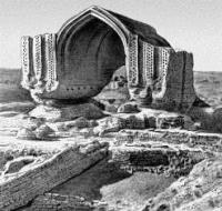
Work on this excavation continued with changes in 2007 and 2009. In 2009, excavations were carried out according to the project of the Khorezm Academy of Mamun. As a result of archaeological research in the Juma mosque, two prayer halls, a winter and a summer one, as well as a courtyard, takharatkhans, a utility room and hujras were identified.
The windows were made of openwork ganch panjara. The mosque in the plan is a trapezoidal shape, with dimensions on the outside of 25.65 (southern wall) x 34.1 meters (eastern) x 22.5 (northern) x 35.15 meters (western).
The walls of the mosque were erected on a compacted surface of pakhsa with a foundation of baked bricks of various sizes. In 2010, to the southwest of the mosque, the explored continued in a new excavation (P # 7). As a result of excavations along the entire perimeter of the excavation, a platform of mud bricks (40 x 40 x 10 cm, 42 x 42 x 11 cm) was revealed.
The excavation was mainly limited to stripping along the surface of the platform to clarify the overall layout in subsequent studies. Only in some places did the deepening reach the surface levels. The platform was partially open.
Along the entire perimeter of the open area, 12 pits were identified, among which there are trash pits with bones and ceramics of the late period (XVIII - XIX centuries). The pits were found mainly in the eastern part of the excavation site.
Because of these pits, the surface of the platform was destroyed, and the masonry of adobe bricks was preserved at different levels. The full structure and function of the platform has not yet been revealed, perhaps this is due to ritual ceremonies.
In order to draw a final conclusion, excavations must be continued in the following years. According to the available materials, it can be said that the platform was possibly erected in the I - III centuries. At the same time, this year, a stratigraphic pit was dug in the southwestern, lowest part of the settlement, in which layers with ceramics of the IVth - IIIrd centuries c. BC e.
In 2011, a 6x2 m trench was made near the northwestern part of the settlement. Layers of the IVth - IInd century BC, and the VIIth - VIIIth centuries BC were discovered here.e. Thus, recent studies complement the historical stages of the settlement's life.
As a result, four construction stages in the development of the city were clarified: IV - III centuries. BC BC, I - III centuries. n. B.C., VII - VIII centuries A.D. e. and IX - XI centuries A.D. The settlement has the shape of a trapezoid in the plan.
The length of the western wall is 300 meters, the eastern one is 256 meters, the northern and southern wall is 281 meters. The area of the monument is about 8.5 hectares. The preserved pakhsov walls rise from the middle part of the settlement by 5 meters from the north-western side and 8 and from the western side, and 8 - 12 meters from the southeast.
In the gullies in the middle of the northern and western walls, a combined pakhsov-adobe masonry is visible. The dimensions of the bricks are 36 - 37 x 38 - 40 x 8 - 11 cm. A brick of a similar size was found from the inner face of the eastern wall.
Fragments of red clay vessels from ancient times are found in the masonry of the walls. In the south-western corners, semi-circular towers are weakly expressed, which protrude 5 - 7 meters beyond the wall line. The settlement had a single entrance from the eastern side, 9 meters wide.
The slopes of the settlement are very steep. The fortress was surrounded by a deep moat, which now looks like a very swampy depression, encircling the fortress along the perimeter. The northern part of the monument is an almost flat lowered area. In the southwest, there are swollen low hills.
The eastern part from the center of the settlement to the gates is occupied by abandoned dwellings of the XIXth century Uzbeks. In the northeastern corner and in the middle of the western part of the fortress, traces of pottery kilns can be traced, around which fragments of burnt bricks and ceramic slags are traced.
Geographic coordinates of the Kyat ancient settlement: N41 ° 42'04.96 "E60 ° 21'14.33"
Authority:
https://ru.wikipedia.org/wiki/%D0%9A%D1%8F%D1%82-%D0%BA%D0%B0%D0%BB%D0%B0