


![]()
You are here
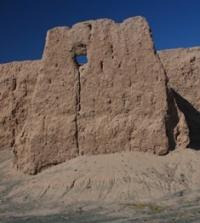
Ancient settlement of Kurgancha kala.
Karakalpakstan tours.
"Lands of ancient irrigation", vast areas of the desert, bearing traces of irrigation and abounding in ruins, have been known in Central Asia, and in particular in the parts of the Kzyl-Kum and Kara-Kum surrounding the Khorezm oasis, for a long time."
Tolstov S.P. "In the footsteps of the ancient Khorezm civilization." 1937 - 1945
Archaeological sites of Karakalpakstan.
The settlement Kurgancha kala is located at an altitude of 53.4 meters above sea level, 1.2 kilometers southwest of Lake Karakol, 16 kilometers east and slightly north, 15.8 kilometers southeast of the village of Daukara, in the Takhtakupyr region of the Republic of Karakalpakstan.
The settlement of Kurgancha kala, this monument is also known under the name "Kublandy kala", since in folk legends it is associated with the name of the epic hero Koblan. The settlement of Kurgancha is located in a desert area.
From the north, east and west, it is surrounded by a thick sandy massif, fixed by vegetation. Abandoned fields adjoin the monument from the south. At 750 - 1000 meters north of Kurgancha, in the latitudinal direction, there is a dry Karakul channel, which is periodically flooded by waste waters, which is perfectly expressed in the relief.
Another dry channel Kargabay runs 2000 meters to the south, it also maintains the general latitudinal direction, but in the relief it is less pronounced than the aforementioned Karakul channel. Both channels are part of the system of the now drying up eastern channels of the Aral delta of the Amu Darya. As shown by the route surveys of the entire system of dry channels carried out in 1960 and 2007 on the eastern edge of the Aral delta of the Amu Darya, the above system includes numerous dry channels: Kamyshly-Kandym-Uzyak, Karakul and smaller channels connecting them - Kargabay, Sazsay, Louzan.
All these channels are densely overgrown with a comb, and in a number of places the comb stretches in a narrow strip, marking a relatively recent edge of the waters. The banks of the channels are, as a rule, steep, the channels are almost not scattered.
All of them are included in the system of the Kuvanyshdzharma direction of the flow of the Aral delta of the Amu Darya. The total area of the settlement is about 18 hectares. The settlement is represented by a very interesting layout, since the general complex of the settlement is taking shape gradually, changing its configuration in each separate period of its existence.
The archaeological complex of Kurgancha (XII - early XIII centuries) consists of a settlement, a tower, a pottery kiln and individual structures, located under the cliff of the Ustyurt plateau, 105 km north-west of the towny of Muynak.
The settlement is repeatedly mentioned in the historical literature of the 19th century. In terms of a rectangular monument, it is oriented to the cardinal points. Rooms are traced along the eastern wall and the eastern part of the northern wall.
In one of them, finds were found in the form of blue glass beads and shells with holes for stringing. The settlement is the remains of a trading post located far to the north, where trade exchanges between the Khorezmians and nomads coming from the north took place. According to research, it was reused in the XIIIth - XIVth centuries.
In the history of the addition and development of the settlement Kurgancha, it was originally planned under a single construction system, but over time, this part of the settlement with a regular layout is fenced off by a rampart.
As a result, the inner part of the settlement of a huge area remains unbuilt. In the future, the eastern part is formed, and an array of houses appears in the southern part. But almost the entire regular part of the settlement's layout, enclosed by a rampart, perishes as a result of a large fire.
Subsequently, this fire, Kurgancha loses the appearance of a single complex. This fire also affected the eastern part of the settlement. All events related to fires and the entire history of construction were recorded by long-term archaeological studies of the Kurgancha settlement, which dates back to the 7th - first half of the 8th century.
The most important and interesting was the discovery to the south of Kurgancha, at a distance of approximately 1.5 kilometers, the recorded remains of a huge unfortified early Kerder settlement with traces of light, probably temporary dwellings.
Geographic coordinates of the ancient settlement Kurgancha-kala: N43 ° 02'23,00 "E60 ° 29'01,00"
Authority:
http://sovminrk.gov.uz
Photos by
Alexander Petrov.