


![]()
You are here
Ancient settlement Karnak. Ishkan.
Medieval settlements of Kazakhstan.
"Any boundaries are historical"
Paul Ricoeur.
Unusual travel in Kazakhstan.
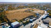
Karnak is a medieval settlement subordinate to the city administration of the city of Kentau in the Turkestan region in the central part of the village of Karnak. In the Middle Ages, the city of Karnak was also known as Shagiljan and Ishkent.
The settlement, which dates back to the XII - XVIII centuries. The settlement of Karnak is a trapezoidal hill approximately 294x224 meters in size and 1.5-2.5 meters high. Along the perimeter, the remains of an earthen rampart up to 1.5 meters high have survived, only the central part has survived, the rest of the territory is occupied by modern buildings.
In the northern part of the settlement there was a citadel measuring 100 × 90 m, reaching 6 meters in height. The entrance gate of the citadel was oriented to the southwest. The rest of the territory was occupied by shakhristan.
In 1947, Karnak was examined by the South Kazakhstan archaeological expedition led by A.N.Bernshtam, in 1986 - by the expedition of the Institute of History, Archeology and Ethnography under the leadership of K.M.Baypakov.
The city of Karnak became famous as the place where the cauldron for the mausoleum of Ahmed Yasawi was cast. It corresponds to the settlement of Ishkan in the village of Karnak (the former name of Atabay), 24.5 kilometers north, slightly east of Turkestan.
In 1992, the village was returned to its former name - Karnak, retaining the name of the medieval city (Baipakov 1977, 203, Masson 1930, 16).
Geographic coordinates of the settlement of Karnak: N43 ° 30'52.52 "E68 ° 20'54.12"
Authority:
https://ru.wikipedia.org/wiki/%
Photo from the site
https://mir24.tv/articles/16434935/borba-s-diabetom-kak-predotvratit-kovarnoe-zabolevanie
Photographers:
Nurzhan Algashov, Ruslan Sherbaev, Maksat Shagyrbai.