


![]()
You are here
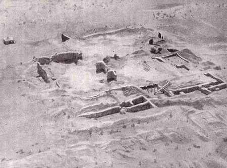
Ancient settlement Kalaly gyr I.

. Taken from the BDT archive.")
Sights of Kunya-Urgench.
“The transition was extremely difficult. The path lay through the rows of huge, menacingly reared manes of dunes. Their crests, on which our camels walked cautiously, plummeted into the gaps of deep "uevs" - blowing hollows. On the bottom of these hollows lying deep below us, the wind whirled whirlwinds of blackish sand sparkling with sparkles of mica.
Ruins were drowned in the sea of dunes - they were not visible either from behind or in front, but our guide confidently led us along a winding path, now skirting the "ui", then climbing the sandy slopes. And suddenly, from the crest of one of the dunes, a wide area of takyrs, covered with a scattering of scarlet-red shards, suddenly opened in front of us.
Above the takyrs, the bizarre outlines of the ruins of a strange fortress rose, unlike anything we had seen so far. The destination of our journey was still far away."
From the report of the expedition 1937 - 1945. Tolstov S.P. “In the footsteps of the ancient Khorezm civilization"
Travel organization services in Turkmenistan.
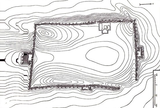
The ancient settlement Kalaly gyr I (Adykyr kala) is a monument of the Kanguy culture, located on a hill 80 meters above sea level near the southern bank of the ancient channel of Daudan, located in the northeastern part of the Karakum desert, 32.8 kilometers southwest of the Akdepe village, 64.4 kilometers to the west and slightly south of the city of Dashoguz, 37.9 kilometers to the west and slightly south of the village of Gurbansoltan-Eje in the territory of the Gurbansoltan-Eje etrap of the Dashoguz velayat.
The ancient settlement of Kalaly gyr of the Vth - IVth centuries BC is the largest monument in the territory of the ancient Khorezm oasis. Its rectangular area is now heavily covered with sand.
Within the walls of the fortress, reinforced with towers, there were four gates, protected by intricate gateway labyrinths and bastions.
The life of the inhabitants of the settlement was concentrated in long narrow corridor-like rooms encircling its entire territory, hidden in the thickness of the powerful fortress walls. Its rectangular area is strongly blocked by sands now. Within the walls of fortress, strengthened by towers, was available four gate protected by difficult labyrinths and bastions.
Life of inhabitants of the ancient settlement was concentrated in the long, surrounding all its territory narrow vaulted corridor hidden in the thickness of powerful fortifications. At the western wall, from the inside, the grandiose palace building (the size of the plan 80 x 80 m) with two internal and two external court yard was located.
On perimeter of the yards about 30 various rooms were located. Halls of the palace had the flat overlapping supported by columns from which constructions partially remained. This building, also as well as "inhabited" walls, remained unfinished as the ancient settlement was left by inhabitants.
The fortress which arose during domination in Khorezm Akhemenidids was necessary to them for ensuring the control over large irrigating systems of South Daudan. The attempt of its construction could log in the actions reflected in Herodotus story about irrigational policy of Akhemenidids tsars.
First described by S.P. Tolstov in 1939, research by S.A. Vyazigin in 1946, Khorezm archeological-ethno-graphic exhibition in 1950, 1953, 1958.
Geographic coordinates of the ancient settlement of Kalaly gyr I: N41 ° 48'04.99 "E59 ° 10'57.74"
Authority:
S.P. Tolstov. "Along the ancient deltas of the Oxus and Yaxart." Eastern literature. 1962.
https://w.histrf.ru/articles/article/show/kalaly_gyr_1