


![]()
You are here
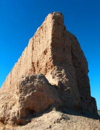
Ancient settlement Dev Kesken.
Itineraries in Karakalpakstan.
“The Sellizur Fortress (Sahri-Vazir -“ the city of Vazir ”) is located on a high hill; here lives a king called khan. The southern part of the fortress is located on low but very fertile land; many beautiful fruits grow here. The water used by the whole country is taken from canals drawn from the Oxus River (Amu-Darya - Daryalyk) to the great depletion of this river; that is why it no longer flows into the Caspian Sea, as in the past. In the not too distant future, this country will probably be devastated and become a desert due to lack of water, when the waters of the Oxus are not enough."
1558. English traveler Anthony Jenkinson.
Seven Wonders of Karakalpakstan.
The settlement Dev Kesken is located in the westernmost part of the southeastern part of the Ustyurt plateau along the western edge of which the state border between the Republics of Uzbekistan and Turkmenistan passes, 62.8 kilometers from the eastern coast to the northeast of Lake Sarykamysh, in the southeastern part of Gross Karabaur, 89.6 kilometers southeast of the southern part of Barsakelmes saline land, 91.8 kilometers southwest of the town of Kungrad in the Kungrad region of the Republic of Karakalpakstan.
Dev Kesken is a multi-layered settlement, probably a border town of ancient Khorezm in Kanpoi and Kushan times (a large city was also located here in the Middle Ages). The area is about 19 hectares. Around the settlement there is a fortress wall with rectangular towers and a powerful moat 2.50 - 3 meters deep.
In the southwest corner of the town there is a citadel (100 x 75 meters), inside which a building, possibly a palace. The first period is associated with the construction of a defensive wall on three sides of the city and, possibly, the construction of a citadel. Towers I - III centuries are surrounded by new external fortress walls.
“The settlement of Dev Kesken is located at the tip of a narrow cape in the southeastern corner of the plateau, in its narrow part, 17.3 kilometers southwest of the fortress, cut by a powerful ditch and rampart. The fortress picturesquely rises above the thirty-meter cliff of Ustyurt, crowned with the magnificent outlines of the mighty muddy tower-citadel and the row of late medieval mausoleums stretching along it.
Dev Kesken is a huge rectangle of walls made of wild stone, with numerous towers and a complex gateway structure.
Around the fortress there is a deep ditch carved into the rock. Inside the walls there are countless traces of destroyed late medieval stone buildings. The foundation of the walls and the citadel dates back to antiquity, but the final period of the city's life falls in the XVIth - XVIIth centuries.
At the foot of the "Upper Town" is located, close to the rock, the second rectangle of the "Lower Town", surrounded by walls of medieval adobe masonry and dated by abundant finds of late medieval ceramics. The city is surrounded by a bend of the branch of the dry river Daryalyk, an old river of the western channel of the Amu Darya, which flows into the Sarykamysh depression, which is close to Ustyurt.
To the southwest of both cities lies the third rectangle - the layout of a vast late medieval park, which makes a very impressive impression from above.
Dev Kesken, as it seems to us, can be accurately identified with the city of Vazir - the late medieval capital of the Western Khorezm appanage principality of the XVIth - XVIIth centuries. Both the topography of the city (a fortress on a hill and a city in a lowland) and its geographical position (two transitions from Kunya-Urgench towards the Mangyshlak pier, i.e. to the west, on the banks of the Daryalyk; in fact, Dev-Kesken is located 60 kilometers away, ie exactly two camel crossings directly to the west of Kunya-Urgench, on the banks of the Daryalyk) do not leave the slightest doubt about the identity of Vazir and Dev-Kesken."
Geographic coordinates of the ancient settlement Dev Kesken: N42 ° 17'21.41 "E58 ° 23'58.58"
Authority:
Tolstov S.P. “In the footsteps of the ancient Khorezm civilization. Part 1"
Vadim Yagodin. http://cheloveknauka.com/fortifikatsiya-drevnego-horezma-vi-v-do-n-e-iv-v-n#ixzz6rM2wJfoo
Photos by
Alexander Petrov.