


![]()
You are here
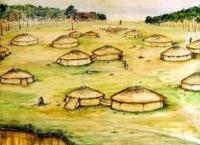
Ancient settlement Ak-Iriy.

Tours in Northern Kazakhstan.
"Glittering clouds run through
Across the blue sky The hill is steep
Illuminated by the autumn sun. River
Runs down the stones with speed.
And on the hill a young alien
Wrapped in a cloak sits motionless
Under the old birch. He is silent
But his chest sometimes rises "
Mikhail Lermontov. August 7th.
Tours on ancient sites of ancient settlement of Northern Kazakhstan.
The Ak-Iriy settlement is located 3.4 kilometers southeast of the village of Dolmatovo in the Kyzylzhar region, Berezovsky rural district. North Kazakhstan region on the right, precipitous river Ishim. The Dolmatovskoye settlement "Ak-Iriy" is an archeological monument of the early Iron Age, located at the junction of the Ishim Plain and the West Siberian Lowland.
The total area of the monument is 22,400 square meters. The monument was discovered and examined in 1966 by G.B. Zdanovich. It was surveyed for the second time in 1968 by the North Kazakhstan archaeological expedition led by S.F. Nabokov and in 1988 by the North Kazakhstan archaeological expedition led by V.F. Seibert.
Revised in 2005 by the exploration detachment of the North Kazakhstan archaeological expedition and in 2004 renamed into the archaeological site Ak-Iriy. The Ak-Ariy settlement dates back to the 5th century BC.
Since 2004, systematic work has begun at the Ak-Iriy settlement, where not only excavations of the monument are carried out, but also the modeling of cultural and historical events of the early Iron Age of the Ishim steppe in the system of the Great Steppe of nomads.
The fortified settlements of the Scythian-Saka period in the north of Kazakhstan, recorded in the form of perfectly preserved remains of the Ak-Iriy settlement and other monuments with majestic fortifications, were a kind of outposts separating the emerging world of the steppe civilization from the inhabitants of the forest zone.
However, the research system and excavations had not conducted here for many years. The stationary excavations started here in 2003. An amazing picture was immediately opened to scientists and archaeologists.
Ak-Ariy ancient town refers to the V century BC, the era of Saka, and ancient settlement was served as a kind of outpost between resident steppes and forests. The defensive moats and ramparts of other fortifications were found in significant buildings.
Inside the fortified city scientists found houses, remains of blacksmith shops and production facilities for the manufacture of ceramics. During excavation, the area of the monument was examined in detail, which is located on the high right bank of the Ishim River, in a place, which is the geographical border zone between the picturesque Ishim plain and southern edge of the West Siberian Plain.
The ancient city was located on a high triangular cape, which is inaccessible from both sides and separated by fortifications. The area of the ancient city was about twenty-five thousand square meters.Archaeologists have given him a very romantic name "Ak Iriy", which means White Paradise. The researchers suggest that the ancient city was built for religious-economic and defensive purposes. According to archaeologists’ version, fortifications belong to steppe Saks, who worshiped to fire and were followers of the Zoroastrian religion.
Zoroastrianism began in the steppes of Eurasia from the Bronze Age and completely rooted to the beginning of the first millennium BC. Scientists will establish the exact layout of the Ak-Iriya after further excavation.
According to all existing signs, it must suit with the previous studied ancient settlement Ak-tau, which is in the boundaries of Petropavlovsk. There have excavated dwelling area of 35 - 45 square meters with pillars at the corners and walls for supporting the roof in the middle.
The walls were built of twigs and were daubed with clay. The same technology was used in the Ak-Iriya, which evidenced by a variety of baked bricks. In the central part of the settlement, on the ground, and area with diverging directions slightly recessed with wide grooves, which were near the fortress wall connected to the bypass road.
According to the findings, the population of the settlement had already reached a sufficiently high level of the development in the period of the Iron Age. Production sites are singled on the monument, in which fixed the concentrated fragments of burnt brick, metal slag.
Found remains of furnaces for smelting indicate that the ancient Sakas were familiar with the technology of steel production. Ramparts were rendered in detail on the modern surface with high up to 1-meter and deep moat was about meter.
The main (central) and auxiliary (side) entrances into the territory of the settlement were revealed during excavation works. It is surprising that cowrie shells, which are in Japan and the Mediterranean, were found in the settlement.
Probably they performed the function of money, which means that Saks had a wide geography of External Relations. Another interesting detail is waterproofing material as the basement of the rampart used birch bark. There was found a furnace, which was used for firing clay and metal smelting
Unique findings allow us to propose the hypothesis that Saka tribes inhabited this territory and had deep roots in the cultures of previous historical stages. In 2013, archaeologists of the North Kazakhstan State University have proposed to open archaeological open-air museum in the Ak-Iriyi settlement.
According to scientists, such museum will attract large groups of tourists, who could well rest on the nature and at the same time visit historical monuments of Kazakhstan.
Scientists’ propose were supported with great interest by public authorities. Creation work of the museum has already begun.
Geographic coordinates of the Ak-Iriy settlement: N55 ° 18'08.59 "E69 ° 30'38.01"
Authority:
http://culturemap.kz