


![]()
You are here
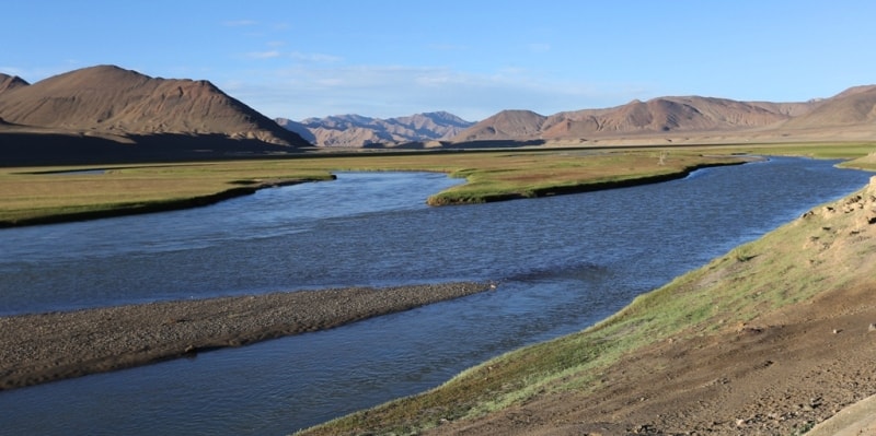
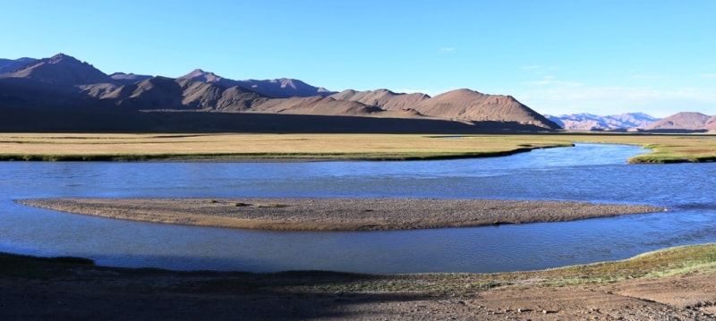
Amu Darya river.

Walks down the river Amu Darya in Turkmenistan.
“It is untrue that equality is a law of nature. Nature has no equality; its sovereign law is subordination and dependence”
Luc de Clapiers de Vauvenargues.
Sightseeing and trekking trip in Turkmenistan.
Amu Darya flow into the Aral Sea and form the Aral Sea Basin. The basin comprises southern Kazakhstan, most of Kyrgyzstan and Turkmenistan, practically the whole of Tajikistan and Uzbekistan, as well as the northern part of Afghanistan and a small portion of Iran.
The Amu Darya, also called the Amu or Amo River, and historically known by its Latin name Oxus, is a major river in Central Asia. It is formed by the junction of the Vakhsh and Panj rivers, in the Tigrovaya Balka Nature Reserve on the border between Tajikistan and Afghanistan, and flows from there north-westwards into the southern remnants of the Aral Sea.
Amu Darya – The Amu Darya, also called the Amu River and historically known by its Latin name, Oxus, is a major river in Central Asia. It is formed by the junction of the Vakhsh and Panj rivers, at Qaleh-ye Panjeh in Afghanistan, in ancient times, the river was regarded as the boundary between Greater Iran and Turan.
In classical antiquity, the river was known as the Ōxus in Latin - a clear derivative of Vakhsh, in Vedic Sanskrit, the river is also referred to as Vakṣu. The Avestan texts too refer to the River as Yakhsha/Vakhsha, in Middle Persian sources of the Sassanid period the river is known as Wehrōd.
The name Amu is said to have come from the city of Āmul, in modern Turkmenistan. Medieval Arabic and Muslim sources call the river Jayhoun which is derived from Gihon, however, this name is no longer used. Hara and to the river of Gozan (that is to say, the Amu the Gozan River is the River Balkh, i. e. the Oxus or the Amu Darya and were brought into Halah, and Habor, and Hara, and to the river Gozan.
In ancient times, the river was regarded as the boundary between Greater Iran and Turan. The Amudarya nature reserve includes the ecosystems of tugai forests in the Amudarya River valley and adjoining desert areas. This nature reserve provides habitats for 48 species and subspecies of mammals, and 203 species and subspecies of birds.
Here 1,040 species of higher plants grow. Among vertebrate animals there are rare species, such as the Central Asian gazelle, Bukhara deer, ratel, otter, marble teal, osprey and others. Among fish species, there are greater and lesser Amudarya false shovelnose sturgeons, and pike chub.
The Amudarya nature reserve manages the Kelif natural preserve that incorporates lake ecosystems in South-East Turkmenistan and is a favorable place for the wintering of migratory and aquatic birds. The river's total length is 2,400 kilometres and its drainage basin totals 534,739 square kilometres in area, providing a mean discharge of around 97.4 cubic kilometres of water per year.
The river is navigable for over 1,450 kilometres. All of the water comes from the high mountains in the south where annual precipitation can be over 1,000 mm (39 in). Even before large-scale irrigation began, high summer evaporation meant that not all of this discharge reached the Aral Sea – though there is some evidence the large Pamir glaciers provided enough melt water for the Aral to overflow during the XIIIth and XIVth centuries.
Since the end of the XIXth century there have been four different claimants as the true source of the Oxus. The Pamir River, which emerges from Lake Zorkul (once also known as Lake Victoria) in the Pamir Mountains (ancient Mount Imeon), and flows west to Qila-e Panja, where it joins the Wakhan River to form the Pyanj River.
The Sarhad or Little Pamir River flowing down the Little Pamir in the High Wakhan Lake Chamaktin, which discharges to the east into the Aksu River, which in turn becomes the Murghab and then Bartang rivers, and which eventually joins the Panj Oxus branch 350 kilometres downstream at Roshan Vomar in Tajikistan.
An ice cave at the end of the Wakhjir valley, in the Wakhan Corridor, in the Pamir Mountains, near the border with Pakistan. A glacier turns into the Wakhan River and joins the Pamir River about 50 kilometres downstream. Bill Colegrave's expedition to Wakhan in 2007 found that both claimants 2 and 3 had the same source, the Chelab stream, which bifurcates on the watershed of the Little Pamir, half flowing into Lake Chamaktin and half into the parent stream of the Little Pamir/Sarhad River.
Therefore, the Chelab stream may be properly considered the true source or parent stream of the Oxus. The Panj River forms the border of Afghanistan and Tajikistan. It flows west to Ishkashim where it turns north and then north-west through the Pamirs passing the Tajikistan - Afghanistan Friendship Bridge.
It subsequently forms the border of Afghanistan and Uzbekistan for about 200 kilometres, passing Termez and the Afghanistan - Uzbekistan Friendship Bridge. It delineates the border of Afghanistan and Turkmenistan for another 100 kilometres before it flows into Turkmenistan at Atamurat.
As the Amudarya, it flows across Turkmenistan south to north, passing Türkmenabat, and forms the border of Turkmenistan and Uzbekistan from Halkabat. It is then split by the Tuyamuyun Hydro Complex into many waterways that used to form the river delta joining the Aral Sea, passing Urgench, Dashoguz, and other cities, but it does not reach what is left of the sea any more and is lost in the desert.
Use of water from the Amu Darya for irrigation has been a major contributing factor to the shrinking of the Aral Sea since the late 1950s. Historical records state that in different periods, the river flowed into the Aral Sea (from the south), into the Caspian Sea (from the east), or both, similar to the Syr Darya (Jaxartes, in Ancient Greek).
The 534,769 square kilometres of the Amu Darya drainage basin include most of Tajikistan, the southwest corner of Kyrgyzstan, the northeast corner of Afghanistan, a narrow portion of eastern Turkmenistan and the western half of Uzbekistan.
Part of the Amu Darya basin divide in Tajikistan forms that country's border with China (in the east) and Pakistan (to the south). About 61% of the drainage lies within Tajikistan, Uzbekistan and Turkmenistan, while 39% is in Afghanistan. The abundant water flowing in the Amu Darya comes almost entirely from glaciers in the Pamir Mountains and Tien-Shan which, standing above the surrounding arid plain, collect atmospheric moisture which otherwise would probably escape somewhere else.
Without its mountain water sources, the Amu Darya would not contain any water - would not exist - because it rarely rains in the lowlands through which most of the river flows. Of the total drainage area only about 200,000 square kilometres actively contribute water to the river.
This is because many of the river's major tributaries (especially the Zeravshan River) have been diverted, and much of the river's drainage is arid. Throughout most of the steppe, the annual rainfall is about 300 millimetres.
Authority:
https://www.britannica.com/place/Amu-Darya
Photos
Alexander Petrov.