


![]()
You are here
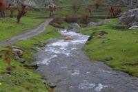
Amankutan river.
Travel through nature of Samarkand region.
“I think you travel to search and you come back home to find yourself there”
Chimamanda Ngozi Adichie.
Sights of nature of Samarkand region.
Amankutansay, Amankutn or Amankutanka (Uzbek. Omonqo tonsoy - Omontonsoy) - a mountain river (gorge) in the Urgut district of the Samarkand region of Uzbekistan, the right component of the Karatepasay river (Zerafshan basin).
The river is 13 kilometers long. The Amankutansay channel on average has a width of 3 – 4 meters, reaching 6 – 8 meters in the widest place and tapering to 1 – 2 meters in the narrowest. The depth near the northeastern tip of the village of Amankutan is 40 centimeters.
The river is fed by both precipitation (snows and rains), and underground, spring waters, whose share is significant. The basin area, counting from the point beyond the Kaflyatunsai confluence, is 57.8 square kilometers (the catchment area above Kaflyatunsay is 24.3 square kilometers, this figure may be indicated in the sources as the area of the entire basin).
The average catchment height is 1601 meters above sea level. The water flow rate, measured at 30 cubic meters per second after the Kaflyatunsay confluence, is 0.951 cubic meters per second, 1 km above the mouth of Kaflyatunsay - 0.575 cubic meters per second. In the spring, mudflow events are observed in the channel.
The maximum recorded water flow was 127 meters cubic per second. During the Kaflyatunsaya confluence, the flow volume per year is 30 million cubic meters, the average flow modulus is 16.5 liters per second, the flow layer is 518 cm / year, the flow variability coefficient is 0.210 (during the observations in 1951 - 1959 and 1969 - 2002).
Amankutansay has hard bottom soil, which is covered with pebbles and boulders. Amankutansay is one of the streams flowing to the Zeravshan River from the western part of the Zeravshan Range, its northern slope.
It is one of the largest gorges in the region along with Agalyk (Akdarya), Urgutsay and Mirankulsay. The course of the river runs through the territory of the Urgut region of the Samarkand region. The sources of Amankutansay are located in the area of the Takhtakaracha Pass, which separates the mountain ranges of Chakalikalan and Karatepa (sections of the Zeravshan Range).
The small streams that make up Amankutansai flow down from the ends of both converging ridges. Different sources consider the source of Amankutansay somewhat different points: east of the pass, on Chakalikalan, indicating a height of 1200 meters above sea level, and west of this pass, in the Karatepa mountains, indicating a height of more than 1600 meters above sea level.
From the source, Amankutansay flows in the general northeastern direction, preserving it up to the village of Kyzylturuk. It has steep banks and passes in a narrow (in the upper part - canyon), the slopes of which are formed by limestone, sandstone and shale.
The Amankutansay valley separates the Chakalikalan mountains (in the south) from the Karatepa ridge (in the north), passing south of its peak, Manganese. On the right bank of the river, a section of the M-39 highway (Bolshoi Uzbek Tract) lies almost along the entire channel.
Somewhat lower than the sources along the banks of the gorge are the buildings of the village of Amankutan, then the settlement of Kyzylturuk is located. In the area of Amankutan and Kyzylturuk on the right bank of the river there is a forest.
Near Kyzylturuk the river turns and is oriented to the north. Before the end of the gorge on its banks are the villages of Urtakishlak, Kizilbash, Karatepa (Karatepa). Near Karatepe, Amankutansay merges with Kuzichisay, forming the Karatepasay river. In the lower reaches it forms meanders, forms three floodplain terraces (the boundary between the second and third terraces is not clearly visible).
Amankutansay receives the waters of a number of small rivers, such as Galabulak, Maydansay, Zhiydasay, Kairagachsai, Bulbulzarsay, Yulsay, Kansai. In the summer months, these streams usually dry out. On the territory of the village of Amankutan, the Kaflyatunsai tributary flows into the river, the basin of which exceeds the higher lying basin of Amankutansay.
A variety of tree species grow in the Amankutansay valley: juniper, cedar, pine, oriental plane tree, elm, ylant, acacia, oak, as well as fruit and berry and walnut trees and shrubs: apple, apricot (apricot), mulberry, walnut, almond hawthorn.
The woodlands in Amankutan are of artificial origin, they represent the first in Uzbekistan experience in creating forests on mountain slopes using the terrace method. Forest plantations have formed dense thickets similar to natural ones, which affect the microclimate of the area, retaining moisture, and resist erosion of slopes (the appearance of ravines, soil erosion).
In addition, they give the area a picturesque view. There are such birds like nightingale, cupcake, quail and other species. The Bulbulzarsay tributary has a large number of nightingales, cupcakes and wild pigeons.
In the Amankutansay valley (on the bank of the right tributary of Bulbulzarsay), an important archaeological monument is located - the parking of primitive people (Mousterian era) Amankutan in the eponymous cave.
Along Bulbulzarsay there is also another site of an ancient man - Takalisay (late Meso era). On the right bank of Amankutansay, on the side slopes of Chakalikalan, the Amankutan forestry was created. Recreation centers, tourist camps, and children's camps were built in the Amankutansay Valley.
In the Soviet years, the pioneer camp located here took over 6,000 children for summer vacations.
Authority:
https://ru.wikipedia.org/wiki/
Photos
Alexander Petrov.