


You are here
Burial grounds of Karagaily in Buyratau park.
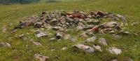
Archaeological sights in Kazakhstan.
“Forgotten dialects sound in you
Sumerians, Huns, hoarse Mongolian words.
Where are you born? In the fires of Semirechye?
You were carried through your veins to us.”
Olzhas Suleimenov. "The language of the fathers, the language of the millennia".
Burial grounds and burial mounds in Kazakhstan.
Burial ground Karagaily - 2 is located at an altitude of 276 meters above sea level, burial grounds Karagaily - 3 and 8 are located at an altitude of 277 meters above sea level, located on the territory of the Buyratau natural park, 2 kilometers northwest and southeast of the village of Karagaily , in the north-east of the valley Sokolinye Gory, in the Yereymentau district in the north-east of the Akmola region.
Exploration of burial grounds began in 1981 and 1988.
The research was carried out by the reconnaissance team of the archaeological expedition of the Karaganda State University under the leadership of A.Yu. Chindina. In 2005 and 2008, the reconnaissance detachment of the AIS under the leadership of I. A. Kukushkin resumed work.
On the territory of the district, 30 monuments of material culture dating back to the Neolithic, Bronze Age, Early Iron Age and Middle Ages were discovered. The burial mounds of Karagaily also belong to this area.
The Karagaily barrow is located 4.8 kilometers southeast of the Karagaily village, the Karagaily barrow 1 is located 3.2 kilometers southeast of the Karagaily village, the Karagaily barrow 2 is located 2.7 kilometers southeast of the Karagaily village.
Geographical coordinates of burial ground Karagaily-2: N51°43'21.53" E72°40'17.41"
Geographical coordinates of Karagaily-3 burial ground: N51°43'06.52" E72°40'44.28"
Geographical coordinates of burial ground Karagaily-8: N51°44'09.67" E72°39'40.81"
Geographic coordinates of burial ground Karagaily-9: N51°44'09.02" E72°42'23.00"
Geographic coordinates of burial ground Karagaily-10: N51°44'15.09" E72°42'33.04"
Geographic coordinates of Karagaily mound: N51°41'45.76" E72°44'07.24"
Geographical coordinates of mound Karagaily-1: N51°42'52.06" E72°43'57.03"
Geographical coordinates of mound Karagaily-2: N51°42'55.00" E72°43'33.09"
Note:
If you are using geographic coordinates for Google Earth or Google Maps navigation systems, you must remove the last two digits from geographic coordinates and " (hundredths of a second) and enter the result in the input line.
Example: N51°44'09.67" E72°39'40.81" = N51°44'09 E72°39'40
Authority:
https://gnpp-buiratau.kz/ru/page/karagayly
Alexander Petrov.
Photos by
Alexander Petrov.