


Вы здесь
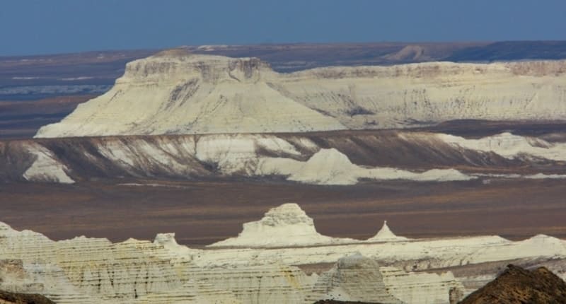
Aktolagai chalk ridge.
Trips on sight of Aktyubinsk province.
“Here life flows through the rifts of time,
Changing days, weeks and centuries,
And for millions of years dawn followed sunsets,
But Aktolagai never lost its greatness.”
Yuri Pastukhov.
Trip to Aktolagay chalk ridge.
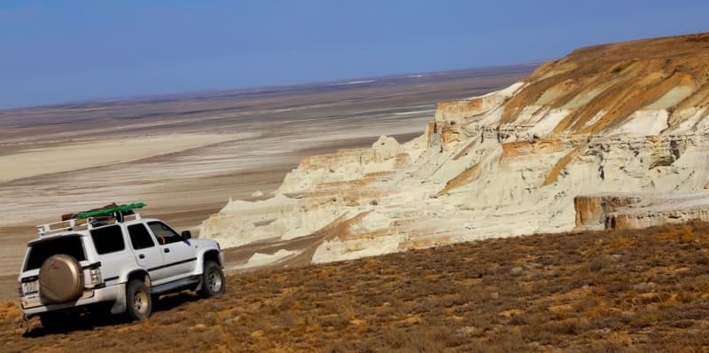
Aktolagai chalk ridge is located at an altitude of 190 to 249 meters above sea level, located 41.3 kilometers northwest of village of Miyaly, 67.6 kilometers northeast of village of Akkiztogay, most of chalk ridge is located in Baiganinsky district in west of Aktobe region, a small part of western ridge is located in Kzylkoginsky district in eastern part of Atyrau region.
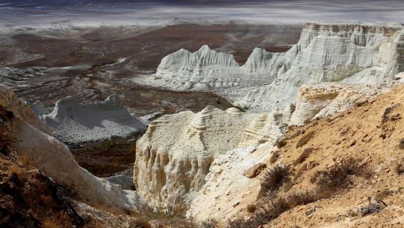
Aktolagai ridge stretches from south to north for 37 kilometers. The greatest width in the southern part reaches 12 kilometers, in the central part in the vicinity of the Akmolalysay tract it is 8 kilometers. The area of the chalk ridge is 322.96 square kilometers, the perimeter reaches 122.2 kilometers.
The ridge stretches in the meridional direction. In the ridge, the highest altitude in the central part is 249 meters above sea level, located west of the Akmolalysay tract. The southern part is dominated by an altitude of 242 meters above sea level.
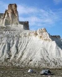
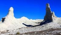
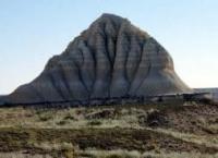
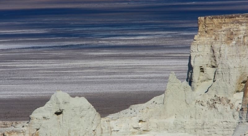
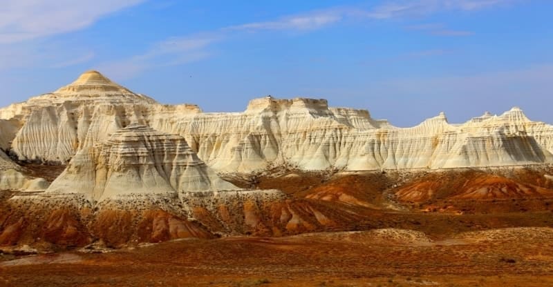
In the southwestern part of the ridge, on the edge of the ridge, Mount Alashen, 240 meters high above sea level, dominates. The most attractive part of Aktolagay for tourists is the southern one. On the southern slope of the ridge you can see a wonderful picture.
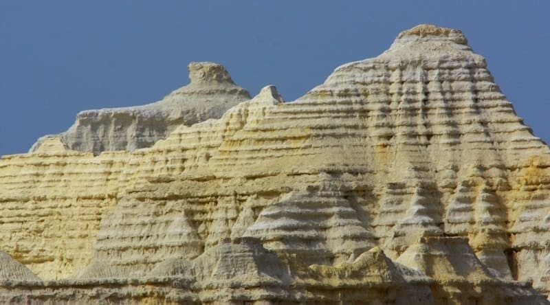
From the foot, several tens of meters up, steep chalk walls rise, turning into snow-white ridges. Above, multi-colored layers of Paleogene rocks darken: beige, greenish, sulfur and brown, ending in broken shell rock. In the east, parallel to the Aktolagai ridge, the Emba River flows from northeast to southwest.
On the eastern side, Aktolagai is bordered by the Alshynsay sands; on the south, the ridge is supported by the small ridge sands of Togalay. Characteristic landscape features of the chalk mountains are extremely sparse cover and amazing diversity of herbs.
The southern part of the Aktolagai ridge is the reference stratigraphic section of Campanian, Maastrichtian, Eocene deposits, unique forms of erosional relief in sedimentary marine deposits. Relief – It is a hilly, dissected plateau-like hill. The hill has steep (10 - 20°) western slopes.
Сlimate of Aktolagai chalk ridge is desert, sharply continental, with large fluctuations in seasonal and daily temperatures, and low precipitation - about 180 mm. Summer is dry, hot, the average July temperature is + 25 + 30 C, maximum up to 43 ° C.
Winter is moderately cold, with little snow. Air temperature 8 - 13 C, minimum up to - 35 C. Average annual wind speed 4 - 5 m/s. In summer, western and southern winds predominate, in winter - eastern and northeastern winds.
Water resources of Aktolagai chalk ridge. There are practically no surface waters, and therefore the territory belongs to the internal drainage region. Surface runoff occurs only during the spring period when snow melts and rains, and in the summer within two to three hours after rain, since salty clays serve as a water stop.
Groundwater is confined to Cretaceous deposits and is fed by infiltration of atmospheric precipitation. Aquifer complexes are represented by different-grained sands, sandstones and sandy-clayey rocks. The chemical composition is varied, predominantly sulfate-hydrocarbonate, sulfate, sodium chloride.
The waters are brackish, water mineralization is 3 - 5 g/l or more. The soil cover is represented by brown soils, desert solonetzic, eroded, underdeveloped and hummocky-ridged semi-fixed and loose sands.
Soils of Aktolagai Cretaceous Ridge - brown soils are formed in elevated areas and between plains in the form of hills and are characterized by the absence of a turf horizon.
Vegetation cover of Aktolagai chalk ridge is semi-desert, represented by grasses (wormwood, feather grass), shrubs (tamarisk, zhuzgun), among which gray wormwood vegetation associations dominate. The sands are dominated by grass-wormwood vegetation. In depressions and sands there are shrubs and saxaul grows.
Fauna of Akolagay chalk ridge is represented by desert species.
Paleontology of Akolagay chalk ridge, reflecting the sun's rays, heats up much less than the dark soils, as a result, a special microclimate is formed here. Once upon a time there was the bottom of the world's oceans. On the ridge you can find paleontological finds: single corals - a fossilized sea urchin, a helmet-shaped sea urchin - Echinocoris, fossilized plant roots.
Shark teeth, dinosaur remains, imprints on stones of unprecedented plants and unknown living creatures - all this can still be found on the chalk ridge. The vibrant, uniquely beautiful Aktolagai plateau was formed during the Jurassic period, when dinosaurs roamed the earth.
Paleontological Museum in Atyrau presents most of the finds from Aktolagay, which were found by the tireless researcher Yuri Pastukhov, here he organized excursions and hikes with students of Atyrau schools. The fantastic landscape of these places is mesmerizing.
It's not just beautiful - it's amazing! The white rocks have such a strong emotional impact on people that once a visitor wants to plunge into the heady atmosphere of natural charm. Aktolagai is inaccessible and remote; tourist routes here can be found on the Silk Road Adventures website.
Geographic coordinates of Aktolagai chalk ridge: N47°27'33 E55°05'55


Authority:
Alexander Petrov.
Ilya Fishman, Yuliya Kazakova “Millions of years before the Silk Road. Geoparks in Kazakhstan”. Printing house “Idan“ Kommunal’naya, 39, Almaty, Kazakhstan http://yadi.sk/d/4_6z_blyoxnqe
Photos by:
Alexander Petrov.