


You are here
Merke ancient settlement.


History of monuments Zhambyl of area.
“Does progress mean that we dissolve our ancient myths? If we forget our legends, I fear that we shall close an important door to the imagination”
James Christensen.
Tourist travel Kazakhstan.
Merke site was investigated for the first time in 1893 - 1994 years by V.V.Bartold, who made scientific trip to Central Asia and passed through Shymkent, Taraz, Tarty (Lugovoye), Mirki, shore of Issykkul Lake, Ili valley. He identified Tarty with Kulan, and Mirki identified with site in Merke village.The site was investigated by Semirechenskay archaeological expedition of Institute of material culture AS USSR and Kazakhstan branch of AS USSR (A.N.Bernshtam) in 1936.
In 1964 investigational excavations in Merke were carried out by Lugovskoy team of Semirechenskay archaeological expedition of Institute of History, Archaeology and Ethnography of Academy of Sciences of Kazakh SSR (K.M.Baipakov). Shaft on citadel cut upper layers, dated by the X - XIII c.c. Collected surface material (ceramics) let to date the site by the VII - XIII c.c.
In 1986 - 1987 monument was studied by archaeological expedition of Code of monuments of history and culture of Institute of History, Archaeology and Ethnography of AS KazSSR (K.M.Baipakov). In 2006 year researches of Merke site were renewed by initiative of Doctor Christoph Baumer, who is heading Public Fund “EurAsia”: Researches of Merke site had previous character. Purpose of excavations is to study topography and stratigraphy of site.
Visual researches were carried out, instrumental plan of site’s remains was taken, fortification constructions were described, and air photos from different heights were done. On the territory of shakhristan of site was put on excavation, which revealed building constructions: dwelling and household constructions, combined by fenced yard. Remains of material culture, revealed from excavation are referred to late time, dated by the XIX – early XX c.c.
On citadel was put stratigraphy shaft in sizes 6,8 x 3 m, reaching mainland layer on the depth 8,5 m. Received complex of materials, mostly ceramic one, and also items of metal and bronze, stone and bone let to distinguish three chronological periods in life of town, such as: VII - VIII c.c., IX - XII and X – early XIII c.c. The site Merke is one of few sites in Semirechie, which kept name of medieval town. In the IX - X c.c. it was mentioned in guidance’s of Kudama and Ibn Khordadbekh, as rich settlement.
Authors used sources of the VIII – early IX c.c. Makdisi informed on Mirki site in the X c. He wrote: “Mirki is a town of average. The Geographical coordinates in the system UTM are North 42° 52' 375 and East 73° 10' 261, alt 711 m. The site is of quadrangular form in sizes 297 x 335 m by the outward contour of walls; it is situated on the first terrace of Koltogan River (absolute height is 694 m).
The site is prolonged by long axis with a small decline (30° in west direction) by the line north-south. Outward walls, which remained on the height from 5 to 15 m in some places, round the territory identified as Rabat (third part of a city after the citadel and the sharistan). The length of east wall (prolonged by the line N – S) is about 315 m, the width on upper square is about 8 m. The wall is destroyed by modern buildings and only central part remained in length of 60 m.
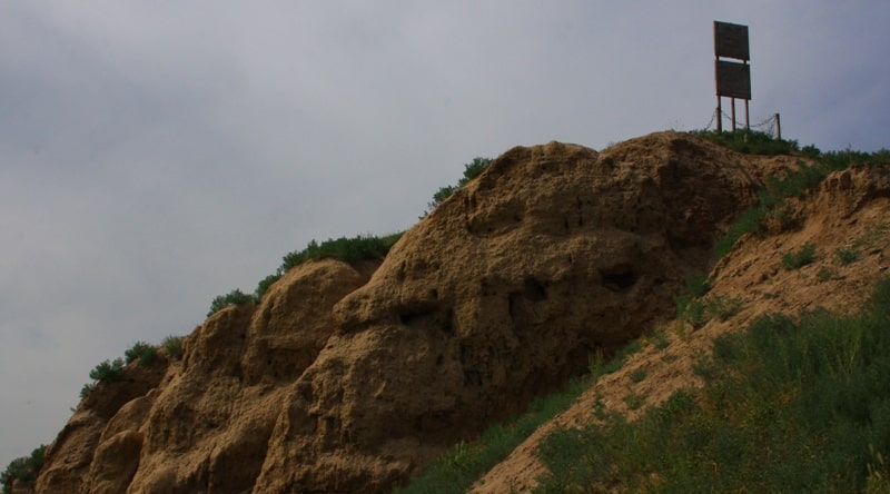
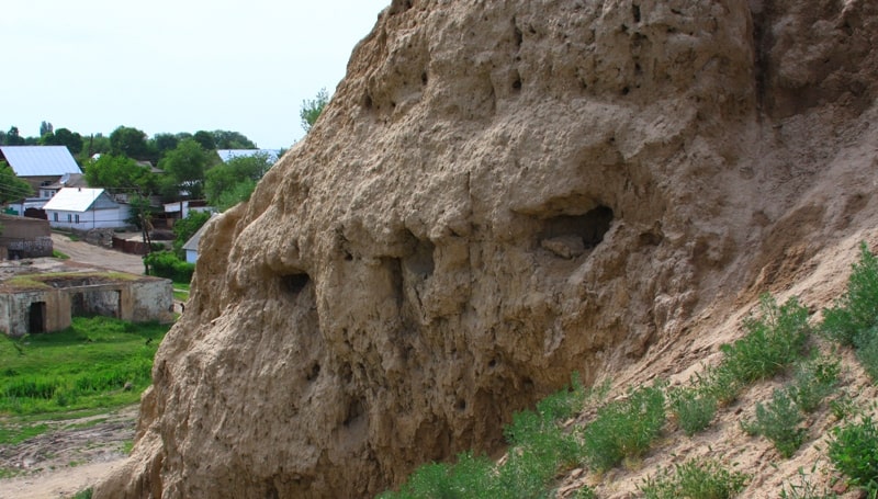
The west wall (prolonged by the line N – S) has a maximum height in the region of the citadel – more than 15 meters. The length of wall is 340 m, thickness about 5 m. Pakhsa (stamped clay) layer of wall is not remained in fact, as west front is being washed out by river continuously – on all parts of walls are seen fresh broken pieces and naked cultural layers. Digital model gives the possibility to see that the central part of the wall has been destroyed by river waters to the depth 14 meters to the side of site's center.
Corner of destruction of this part is 90 degrees and in some places guest to the negative marks. North corner has a good safety and at the same time the south part of wall is destroyed by modern asphalt entrance to the site and the monument put in the second half of the XX century. The North wall prolonged by the line W – E is in length about 300 m. The remained thickness of the wall is 6 - 7 meters by upper square, the remained height is 4 - 6 m.
The East part of wall is destroyed by modern economic constructions. In the central part of wall is the entrance in width 18 m. In 60 meters from the west corner the wall has rough lowering for 2-3 meters, probably, it is the result of today's economic activity. From outward (north) side of wall is read the essential lowering (alt 694 m), of under rectangular form 67 x 80 m, which can be defined surely as water reservoir.
Territory surrounding the reservoir is raised for 2 - 2,5 m (alt 694 m). South side of reservoir joins to the wall in the place of lowering. Territory going to the entrance in the north wall is going up essentially (for 1,2-2 m), what is the evidence of presence of pandus in this part. On the upper line of south wall is built modern administrative construction including Prosecutor's office. By that reason the wall was leveled. The length of south wall is about 300 m. Total square of rabat is more than 92000 m.
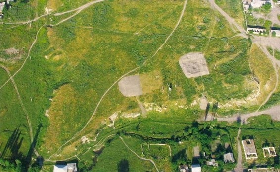
The size of the outward walls is from 6 to 8 m to one side. The central ruins of Merke represent a rectangular in plan hillock, prolonged by the line E – W. North side is equal to 380 m, east side is equal to 275 m, west side is equal to 250 m. In the south-west part of the site are seen the remains of the Citadel. It is separated from the Shakhristan (fortified city excluding the citadel) by the wall transferred to the swollen, strongly ground hill in height 1,5 - 2 m.
Corners of walls are strengthened by round towers, two more towers flanked the entrance to citadel in the south-west corner of south wall. On the surface of citadel are seen the remains of constructions in a form of different size and form hillocks. To the middle of west wall of citadel joins the rectangular hill in height 4,5 m over the general surface. On the top of hillock is the plain square in sizes 17 x 10 m.
The Citadel is also of a quadrangular form in sizes 60 x 60 m; it lies in the south–western quarter of the shakhristan, - as in several other ancient cities of Semirechi - raising over the last one for 4 m. Width of walls is 4 meters. Preservation is satisfactory. Strong swollen and also modern channel, in depth 2 m, in width 13 m established in the inner surface of citadel, along its east wall make difficult reading of entrances and exact form of fortification constructions.
To the north wall of citadel joins the construction tortkul (50 x 50 m), identified during archaeological researches of 2006, as dwelling farmstead of Kokand time of the 18-19 century with a big yard (dwelling constructions occupy east part of tortkul, the yard occupies west part). In the south-west part of citadel is the hillock with flattened square, in sizes 10 x 10 m in height about 3 m. Probably is that swollen of hillock is hiding the ruins of Kokand time tower.
Corner of swollen of hillock is 35 - 40 degrees. General Square of citadel amounts more than 2400 m . The Shakhristan is of quadrangular form in sizes 175 x 175 m, is situated in the center of west part of square of outward walls of rabat. Outward west wall of rabat is from 2 to 3 - 4 m high, the width by the upper square is about 4-6 meters and south wall is destroyed by modern economical construction.
North wall in the central part is going down from the level 703.6 up to 701,6 transferring into the square of rabat. In the centers of these walls remain the positive corner in 25 - 30 degrees and 4 meter height. The East wall of the shakhristan remains much better, but the south corner is destroyed by modern buildings. West wall is washed out by Koltogan River waters, mentioned above. In south-west quarter of shakhristan are fixed the pits in depth up to 2 meters, dogged up in the second half of the XX century.
Reading of entrances to the territory of shakhristan is difficult. General Square of shakhristan is more than 25000 m. From the south and east sides of the site, on the distance 1,6 - 1,8 km, a long outer wall was identified surrounding the town: general length of wall is 5,5 km, thickness of wall is 10 - 20 m (by outward contour of swollen), maximum remained height is about 2 m. It is mostly destroyed.
The parts, where is now modern ground road, remained and also separate parts of wall on the territory of private farmsteads. General theoretical calculated square of surrounding (by the remaining section of walls) is about 100000 m (10 hectares). Researches of Merke site have the previous character and they are connected with carrying out of works on study topography and stratigraphy of site and also possibilities of transference of medieval monument into one of tourist centers on the route of Great Silk Road.
Such task, defined in the State Program “Cultural Heritage: monuments of archaeology” supposes wide enough research of archaeological object, like excavations and reveal of synchronous cuts on possible big square, which let to reveal architectural-planning construction of town: dwelling and public constructions – blocks, mosques, bazars, communications – water pipes, main streets, inner block streets and end sides; handicraftsmen workshops.
Moreover, wide scale excavations let to get material things, which together with other evidences let to form imagination on economical activity of local population. It is understood, that wide scale excavations will demand also corresponding material contributions and obligatory carrying out of conservational and restoration works. As the result of two years of works we revealed stratigraphy of that part of site, which is being washed away by river.
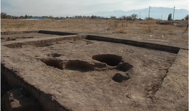
On the territory of site’s shakhristan in 2006 year was put excavation, which revealed building constructions, like dwelling and household constructions, consolidated by fenced yard. Artifacts, received from excavation site showed that constructions are referred to the XIX – early XX c.c.
Excavations of field season of 2007 year, carried out also on shakhristan showed absence of constructions of Kokand time. Remains of building constructions in a form of walls, paving of floors, presence of fire-places-tandyrs were discovered in cultural layers of excavation site.
Collection of ceramics – unglazed household dish and dish, glazed and decorated by different ornamentation has origin from filling between walls and also from debris pits. Besides that, several fragments of glass items were found.
Subjects of material culture from excavation site let to date layer between marks - 0,55 m and - 1,03 m on ceramics by the IX - XI c.c and to date glass by the IX-XI cc. Regrettably, destruction of site by modern building works, presence of digging places and modern debris dumps, net of roads, which break cultural layers, bringing down of western part into river, made it difficult to carry out researches and do not let to spread here scale researches.
Authority:
http://www.exploration-eurasia.com
Photo
Alexander Petrov.