You are here
Historical Cultural Park Ancient Merv.


Turkmenistan travel.
“The oasis formed part of the empire of Alexander the Great. The Seleucid king Antiochus I Soter (281-261 BC) rebuilt it and named it Margiana Antiochia; it is identified with Erk Kala and Gyaur Kala. Islam became dominant with the death of the last Sassanian king, Yazdigird III, in 651”
Silk Road tours in Turkmenistan.
Merv is the oldest and best-preserved of the oasis-cities along the Silk Route in Central Asia. The remains in this vast oasis span 4,000 years of human history. A number of monuments are still visible, particularly from the last two millennia.
The State Historical and Cultural Park “Ancient Merv” is the oldest and most completely preserved of the oasis cities along the Silk Roads in Central Asia. It is located in the territory of Mary velayat of Turkmenistan.
It has supported a series of urban centres since the IIIrd millennium BC and played an important role in the history of the East connected with the unparalleled existence of cultural landscape and exceptional variety of cultures which existed within the Murgab river oasis being in continually interactions and successive development.
It reached its apogee during the Muslim epoch and became a capital of the Arabic Caliphate at the beginning of 9th century and as a capital of the Great Seljuks Empire at the XI - XIIth centuries. Today “Ancient Merv” is a large archaeological park which includes remains of Bronze Age centres (2500 - 1200 BC) such as Kelleli, Adji Kui, Taip, Gonur, and Togoluk; Iron Age centres (1200 - 300 B.C.) such as Yaz Gobekli Depes and Takhirbaj Depe.
The historic urban centre and the post-medieval city, Abdullah Khan Kala. The inscribed property covers the area of 353 ha with a buffer zone of 883 ha. The historic urban centre consists of a series of adjacent walled cities: Erk Kala, Gyaur Kala and the medieval Sultan Kala or Marv al-Shahijan. Erk Kala (20ha), is a walled and moated polygonal site with walls surviving to some 30 m and an internal citadel.
Gyaur Kala, is roughly square in plan, with walls about 2 km long. In the interior are the remains of a number of important structures: the central Beni Makhan mosque and its cistern; the Buddhist stupa and monastery; and the “Oval Building” consisting in a series of rooms around a courtyard on an elevated platform.
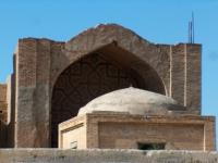
Medieval Sultan Kala was walled in the XIth century, with its Mausoleum of Sultan Sanjar (1118 - 1157) which originally formed part of a large religious complex; the fine details of the Mausoleum such as the elegant brickwork, the carved stucco, and the surviving mural paintings, make it one of the most outstanding architectural achievements of the Seljuk period.
The walls (12 km) of the medieval city and of the citadel (Shahriyar Ark) are unique and represent two consecutive periods of XIth - XIIIth centuries military architecture, including towers, posterns, stairways, galleries, and in places, crenellation.
In addition to these main urban features, there are a number of important medieval monuments in their immediate vicinity such as the Mausoleum of MuhammadI ibn Zayd. The walls of the post medieval city are of exceptional interest, since they continue the remarkable continuous record of the evolution of military architecture from the Vth century BC to the XVth - XVIth centuries AD.
There are also major monuments from different historical periods in the oasis. Among them it can be mentioned the köshks, one of the most characteristic architectural features of the oasis, fortresses and many fine mosques and mausoleum.
Criterion (ii): The cities of the Merv oasis have exerted considerable influence over the cultures of Central Asia and Iran for four millennia. The Seljuk city in particular influenced architecture and architectural decoration and scientific and cultural development.
Criterion (iii): The sequence of the cities of the Merv oasis, their fortifications, and their urban lay-outs bear exceptional testimony to the civilizations of Central Asia over several millennia.
All elements necessary to express the values of the State Historical and Cultural Park “Ancient Merv” are included within the boundaries of the World Heritage property and buffer zone which ensures the complete representation of its significance as an architectural and cultural site.
Ancient Merv represents a system of sites built at different times following the changing course of riverbed of the Murgab river and its gradual shifts from the east to the west. New sites were constructed after old ones were abandoned and never again occupied, thus becoming unique “memory keepers”.
Archaeological layers were not covered by the subsequent developments so the ruins of massive earthen buildings retain the characteristics of original structures which did not undergo to reconstruction and alteration.
Conservation actions implemented at the property have centred on addressing current conditions, particularly potential threats such as an anthropogenic change of the landscape and influence of natural factors such as a deflation, underground water levels rising and connected with it a salinisation of earthen constructions.
It is difficult to generalize about the authenticity of so vast and complex a property as the State Historical and Cultural Park “Ancient Merv”. The archaeological sites have been relatively untouched and so their authenticity is irreproachable.
Restoration and conservation interventions at some of the Islamic religious structures during the 20th century have not been carried out according to existing conservation principles, though they may be defended as essential to stabilize and ensure the continuity of these “living” monuments.
They have been well documented and it is possible to reverse them if required. In any case, they represent only a minute proportion of the totality of this ancient landscape and its monuments. Conservation policies for the property will need to consider guidelines that meet current conservation standards so as to prevent potential impacts to the authenticity of the component parts of the property.
Protection and management requirements The State Historical and Cultural Park “Ancient Merv” was created by decree in 1987 and has additional protection at the national level granted by the provisions of the 1992 Law on the Protection of Turkmenistan Historical and Cultural Monuments.
The Park is the property of the Republic of Turkmenistan and all its components are included in the National Heritage List. Listing in the National Heritage List implies that any proposed action to be taken inside or outside of boundaries of National Heritage place or a World Heritage property that may have a significant impact on the heritage values is prohibited without the approval of the authorized government body.
A protection agreement which secures an inviolability of monuments and maintenance of conditions of economic activities and new constructions within boundaries of the buffer zone has been concluded between administration of the Park and local authorities.
Archaeological excavations, within the Park require official permits from the Ministry of Culture. The overall management system for the property is adequate, involving both government administrative bodies and local communities, although plans for the sustainability of the landscape that respect local farming and agricultural traditions need to be better developed.
The present state of conservation is good. The property is maintained and preserved through regular and rigorous repair and conservation programmes. The Management Plan of the State Historical and Cultural Park “Ancient Merv”, currently in place, takes into account a wide range of measures under planning and heritage legislation and policies of the Turkmenistan Government.
The Management Plan provides the policy framework for the conservation and management of the “Ancient Merv” and it is scheduled to be updated every 6 years. In regard to long term management issues, the property requires balanced management of conservation activities and passing both traditional and modern conservation techniques from one generation to the next.
Management of high pressure derived from tourism activities and urban growth also will be a long-term concern. The sequence of the cities of the Merv oasis, their fortifications and their urban layouts bear exceptional testimony to the civilizations of Central Asia over several millennia.
They exerted considerable influence over the cultures of Central Asia and Iran for four millennia. The Seljuk city in particular influenced architecture and architectural decoration and scientific and cultural development.
The oasis of Merv in the Karakum Desert, at the crossing point of the Amu Darya on the main east-west route to Bukhara and Samarkand, has supported a series of urban centres since the IIIrd millennium BC. The earliest Bronze Age centres (c . 2500 - 1200 B.C.) were located in the north of the oasis.
With the development of more advanced irrigation techniques, the centres moved further south and east of the oasis. It consisted of a series of adjacent walled cities. The oasis formed part of the empire of Alexander the Great.
The Seleucid king Antiochus I Soter (281 - 261 BC) rebuilt it and named it Margiana Antiochia; it is identified with Erk Kala and Gyaur Kala. Islam became dominant with the death of the last Sassanian king, Yazdigird III, in 651.
The medieval city of the Seljuks developed to the west of Gyaur Kala. It was walled by Sultan Malikshah. The city was the capital of the Great Seljuk Empire, and was one of the principal cities of its time. Its famous libraries attracted scholars from all over the Islamic world.
In 1221 - 1222, when it was sacked by the Mongols, and in the 16th century, Merv came under the domination of the Uzbek Turks, and a century later it was incorporated into the Persian Empire. An increase in population in the XVIIIth century led to the creation of a fortified extension, known as Bairam Ala Khan Kala, now mostly ruined.
The five earliest settlements, in the northern part of the oasis, are Kelleli, Adji Kui, Taip, Gonur, and Togoluk. Kelleli is an area of settlement with two major sites: Kelleli 3, which has a double external wall with towers flanking four symmetrical entrances and an area of houses that has been cleared in the south-western sector, and Kelleli 4, which also has a double outer wall with towers. Both sites are poorly preserved, but they contain important evidence of middle Bronze Age Margiana.
Adji Kui is from the same period. Taip is constituted of two close but distinct mounds consist of a walled square area with a large courtyard building in the south. The largest and well-preserved site in the Murghab delta is Gonur Depe.
The Toguluk area was densely occupied during the Bronze Age. Excavations have revealed the remains of several large fortified buildings. Two Iron Age centres are Yaz/Gobekli Depes and Takhirbaj Depe. Takhirbaj Depe is the most prominent site in the whole area.
Yaz Depe is of special importance for the fact that it has produced abundant ceramic finds that provide the basic typology for the period. Nearby is the well-preserved Partho-Sassanian rectangular fortress of Gobekli.
The historic urban centre consists of three principal elements: Erk Kala, Gyaur Kala, and the medieval city of Sultan Kala or Marv al-Shahijan. Erk Kala is a walled and moated polygonal site with walls surviving to some 30 m and an internal citadel.
Gyaur Kala is roughly square in plan, with walls about 2 km long. In the interior are the remains of a number of important structures: the central Beni Makhan mosque and its cistern, the Buddhist stupa and monastery, the 'Oval Building' in the north-west quarter.
Sultan Kala was walled in the XIth century, with its Mausoleum of Sultan Sanjar and the unique walls of the medieval city and of the citadel. The walls and moat of the XVth century, but only a few walls of the palace, that survive in the citadel, are of exceptional interest in that they continue the remarkable continuous record of the evolution of military architecture from the Vth century BC to the XVth - XVI16th centuries AD. There are many fine mosques and mausolea from this period in the oasis.
The oasis of Merv in the Karakum Desert has supported a series of urban centres since the 3rd millennium BC. The earliest Bronze Age centres (2500 - 1200 B.C.) were located in the north of the oasis, where the Murghab river came to the surface and could easily be utilized.
With the development of more advanced irrigation techniques, the centres moved further south, and there is a series of important Early Iron Age sites. The historic urban centre developed around 500 BC to the east of the oasis, where it was well sited to take advantage of routes to the east. It consisted of a series of adjacent walled cities, occupying an area of more than 1200ha.
The oldest of these, Erk Kala, is attested in written sources from the Achaemenian period (519 - 331 B.C.), most notably on the famous trilingual inscription of Darius the Great at Bisitun in western Iran. The oasis formed part of the empire of Alexander the Great, and Pliny the Elder suggested in his Natural History (VI, XVI - XVII) that the Hellenistic city was founded by Alexander himself.
The Seleucid king Antiochus I Soter (281 - 261 B.C.) rebuilt it and named it Margiana Antiochia; it is identified with Erk Kala and Gyaur Kala.
It was occupied for some 1500 years, throughout the Parthian and Sasanian periods and into the early Islamic period. It has been suggested that Greek and Roman soldiers, survivors of the crushing Parthian defeat of the Romans at Carrhae in 53 BC, may have been settled at Margiana.
Islam became dominant with the death of the last Sasanian king, Yazdigird III in 651. However, Merv was little more than an industrial zone in the 8th-10th centuries, although the central mosque continued in use as late as the XIth - XIIth centuries.
The medieval city of the Seljuks developed to the west of Gyaur Kala, replacing it as the urban centre as the latter declined. It was walled by Sultan Malikshah (1072 - 1092), and further suburban developments to the north and south were later also walled by Sultan Sanjar (1118 - 1157).
The city, extending over more than 600ha, was the capital of the Great Seljuk Empire (XIth - XIIIth centuries), and was one of the principal cities of its period. Its famous libraries attracted scholars from all over the Islamic world, including the astronomer-poet Omar Khayyam and the geographer Yaqut al Hamavi.
This brilliant flowering came to a violent end in 1221 - 1222, when it was sacked by the Mongols, who slew many of its inhabitants and destroyed the complex water system. It survived in a much diminished form, as part of the empire of Timur (1370 - 1405).
The new and much smaller city, known today as Abdullah Khan Kala was built on another site to the south by Timur's successor, Shah Rukh (1408 - 1447). In the XVIth century Merv came under the domination of the Uzbek Turks, who ruled from Bukhara, and a century later it was incorporated into the Persian empire.
An increase in population in the XVIIIth century led to the creation of a fortified extension, known as Bairam Ala Khan Kala, now mostly ruined.
Authority:
http://whc.unesco.org
Photos
Alexandr Petrov.


